




-
大河三角洲、河口海岸沉积物是全球气候—海平面变化、人类活动等事件的有效载体,包含丰富的环境变化信息(Santschi et al.,2007;Chen et al.,2009)。在漫长的地质历史中,偶发的地质事件导致河口海岸的沉积间断,使其丢失环境信息,一定程度上影响研究人员对古环境变化的反演。而海岸潟湖或者海湾由于其封闭性以及稳定性,保留了更加完整的沉积记录,是反演古环境变化的理想区域(Nichol et al.,2007;张振克等,2010)。
新英湾位于海南省西北部、儋州市中北部,是一个三面受陆域环抱的半封闭海湾。新英湾属于洋浦湾的内湾,与洋浦湾是两个相互分隔而又相互沟通的海湾,两湾的水体依白马井北侧的水道相互沟通,同时接受海南岛内物质剥蚀以及洋浦湾的物质交换(林国尧和李文欢,2009)。第四纪以来,海南岛北部大范围区域垂直差异升降运动、全球气候多次冷暖交替和相应的海平面升降变化,均引起了海南岛沿岸海平面升降和海岸线变迁(孙倩文等,2019;Ling et al.,2020;梁定勇等,2021)。此外,新英湾附近保留了一套更新世海相沉积地层(王梦媛等,2016;禤宇添等,2022),为反演更新世以来气候与环境变化、海陆物质交换等提供了良好的研究窗口。
姚衍桃等(2009)对新英湾北部莲花山海相地层剖面开展了详细的沉积学分析,通过岩性、地貌特征等反演了区域海陆变迁。新英湾以西的排浦镇沿岸出露一套晚更新世海滩岩(张明书,1990;王建华等,1995),林义华等(2023)对其开展了详细的地球化学分析,发现其沉积于风化减弱、气候逐渐干旱的热带海洋环境。新英湾以东,梁定勇等(2021)对海口江东新区上百个地质钻孔对比,结合沉积学和年代学数据,建立了海南岛北部新近纪—第四纪沉积特征与沉积演化模式,随后张磊等(2022)对琼北中新统—中更新统进行Sr-Nd同位素分析,认为沉积物主要来源于海南岛本地花岗质岩石。综上,海南岛北部更新世以来的古环境研究多集中在部分露头,而通过地球化学手段开展更新世—全新世以来这一时间尺度的沉积演化和物源研究较少。得益于儋州新英湾ZKDZ01钻孔获得更新世以来连续地层样品(郑志锋等,2022),本文对其沉积物进行主量元素及Sr-Nd同位素分析,讨论新英湾更新世以来沉积演化以及古环境演变过程。
-
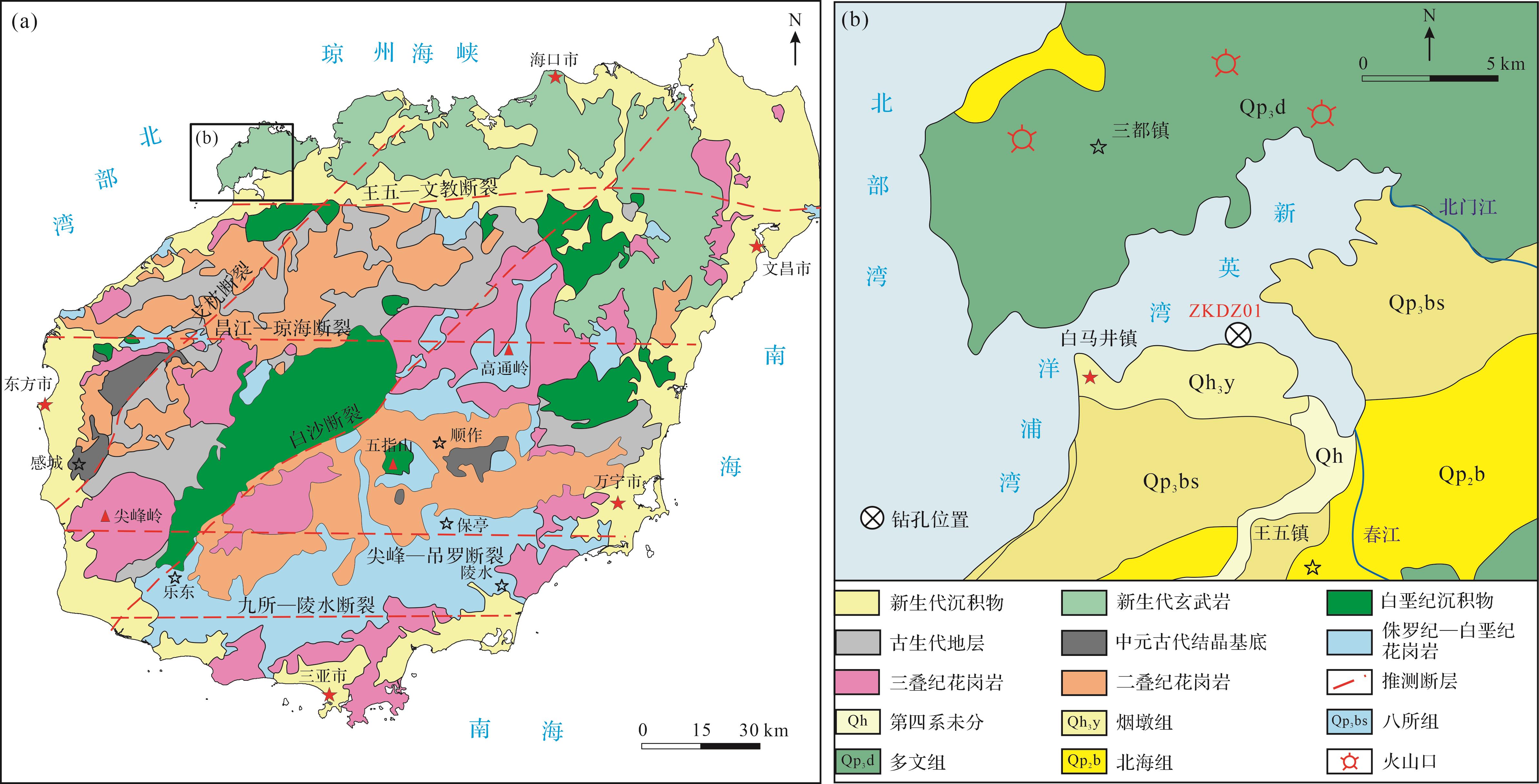
海南岛位于南海西北部,是中国第二大陆缘岛,北经琼州海峡与雷州半岛分隔,西临北部湾,东临南海。海南岛地形呈中间高、四周低的穹隆状,水系以五指山为中心,呈放射状流入南海。海南岛地处欧亚板块、印度—澳大利亚板块以及太平洋板块交汇处,被认为是华夏地块的一部分(Li et al.,2002)。海南岛以岛内东西向九所-陵水深大断裂带为界限分为两个构造单元,断裂带以南为三亚地块,以北为琼中地块(Wang et al.,2016)。王五—文教断裂带又将琼中地块一分为二,九所—陵水断裂带至王五—文教断裂带划分为五指山褶皱带,王五—文教断裂带以北至琼州海峡及其两岸琼北和雷州半岛在内的地区划分为雷琼断陷(图1a)。新英湾是雷琼凹陷的组成部分,位于雷琼凹陷西南部的琼西北断陷区,属雷琼沉降带南端。海湾北岸主要是由火山熔岩构成的玄武岩台地,南岸则是由松散沉积层组成的堆积平原(图1b)。

图 1 (a)海南岛区域地质图(张磊等,2022);(b)新英湾ZKDZ01钻孔位置图(Zhu et al.,2026)
Figure 1. (a) Regional geological map of Hainan Island (Zhang et al., 2022); (b) location of borehole ZKDZ01 in Xinying Bay (Zhu et al., 2026)
-
前寒武纪基底出露于海南岛西部,主要由中元古代结晶基底构成(Li et al.,2008;Zhang et al.,2018)。古生界主要分布在白沙断裂带以西,主要由砂岩、页岩和灰岩构成(张立敏等,2017)。中生代花岗类岩石约占岛屿面积的40%,主要分布在王五—文教断裂带以南,年龄为二叠纪—三叠纪和侏罗纪—白垩纪(Zhou et al.,2015;He et al.,2020)。海南岛沿岸则出露新生代沉积地层,王五—文教断裂以北的雷琼凹陷发育巨厚的晚新生代海相、海陆过渡相、陆相沉积物和新生代玄武岩(图1b)。
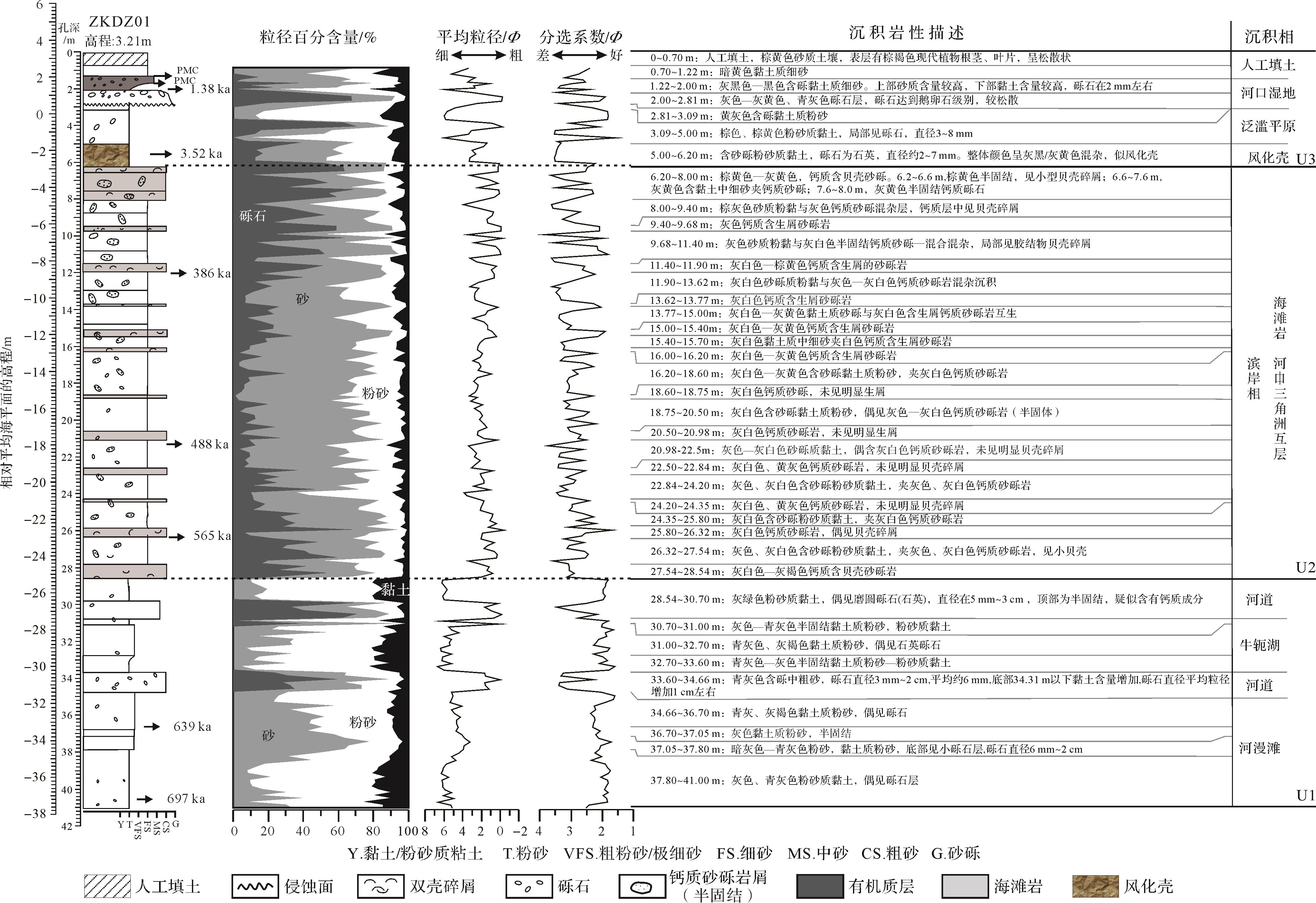
研究区表层被第四纪地层覆盖,上部为第四系全新统海相沉积(Q4)地层,下部为更新统(Q1)黏土和新近系粉质黏土。根据钻孔岩性、结构、粒度、沉积相等特征,将钻孔自下而上分为U1、U2和U3三个沉积单元(Zhu et al.,2026)。U1段为河道—河漫滩—牛轭湖相沉积,底部3 466~4 100 cm为河漫滩相,以细粒粉砂、粉砂质黏土为主;河道相主要位于3 360~3 466 cm、2 854~3 070 cm段,以青灰色含砾中粗砂为主,分选性差;牛轭湖相出现在3 100~3 360 cm处,以青灰色—灰色半固结黏土质粉砂—粉砂质黏土为主。ESR年代学分析测得U1段底部沉积年龄为697 ka,中部为639 ka,顶部推测为约600 ka(Zhu et al.,2026)。U2段位于钻孔中部620~2 854 cm,整体粒度相对较粗,以浅海相、滨海相和河口三角洲相互层为主,该段出现海滩岩沉积,钙质含量较高,见明显的生物碎屑,三个ESR定年结果显示其沉积年龄分别为565 ka、488 ka和386 ka,推测该段沉积年龄为300~600 ka(Zhu et al.,2026)。U3段位于钻孔上部122~620 cm,底部为风化壳层沉积,整体呈灰黄色,以含砾粉砂质黏土为主,14C定年显示年龄为3.52 ka(Zhu et al.,2026)。风化壳之上为泛滥平原和河口湿地沉积,泛滥平原以细粒黏土质粉砂和细砂为主,局部见砾石,河口湿地则以粒度较大的鹅卵石为主,向上转变为细砂,整体有机质含量较高,14C年龄结果为1.38 ka(Zhu et al.,2026)(图2)。

图 2 ZKDZ01钻孔综合柱状图(Zhu et al.,2026)
Figure 2. Stratigraphic columns of borehole ZKDZ01 (Zhu et al., 2026)
-
钻孔ZKDZ001(19°43′27″ N,109°16′21″ E)采自儋州市白马井镇南岸村,孔口高程3.21 m,钻孔总进尺4 100 cm,岩心长4 024 cm,岩心采取率达98.17%。除钻孔顶部人工扰动层(0~70 cm)不进行取样分析,其余70~4 100 m柱状样品以间隔约20 cm取样,选取其中42件样品进行全岩主量元素、微量元素分析测试,20件样品进行全岩Sr-Nd同位素组成分析测试。全岩主量元素以及全岩Sr-Nd同位素组成分析均在中国地质大学(武汉)地质过程与成矿预测全国重点实验室完成。
全岩主量元素利用日本理学 PrimusⅡ X射线荧光光谱仪(XRF)分析完成。样品经研磨至200目后置于105 ℃烘箱中烘干12 h,随后称取约1.0 g烘干样品置于恒重陶瓷坩埚中在1 000 ℃马弗炉中灼烧2 h,取出冷却至室温称量并计算烧失量。称取0.6 g灼烧后样品与6.0 g助熔剂(Li2B4O7∶LiBO2∶LiF=9∶2∶1)、0.3 g氧化剂(NH4NO3)一并置于铂金坩埚中经1 150 ℃熔融14 min,取出坩埚转移到耐火砖上冷却后形成玻璃片进行XRF测试。测试过程中,加入GBW07103、GBW07104、GBW07105、GBW07111、GBW07112国家标准物质作为质量监控。10个主量元素测试结果绝大部分与推荐值的偏差小于2%[(测量值/推荐值-1)×100],表明分析测试结果准确可靠。同时随机选择3个待测样品做重复样,采用和待测样品相同的前处理过程和分析测试流程,10个微量元素的重现性在5%范围之内,表明分析测试结果的可重现性良好。
地质样品的全岩Sr-Nd同位素组成分析流程按照魏雨秋等(2023)描述的方法进行处理,称取50~100 mg样品至特氟龙消解罐,分别加入2 mL氢氟酸和1 mL硝酸密闭加热至120 ℃消解48 h。蒸干后使用1 mL浓硝酸赶酸两次去除氟化物后加入王水消解24 h。待样品完全消解后,蒸干。加入0.5 mL盐酸后再次蒸干并重复此步骤2次。所得样品溶解在1 mL 2.5 M盐酸上载到阳离子柱子,采用4 mL ×4 mL 2.5 M盐酸去除大部分杂质元素,随后用15 mL 2.5 M盐酸接收Sr组分。接着采用10 mL 4 M盐酸淋洗树脂,最后用10 mL 4 M盐酸接收REE组分。Sr和Nd组分的进一步分离分别采用Sr特效树脂和Ln树脂完成。Sr特效柱上,采用4 M硝酸洗脱残留的Rb、Ca和K等干扰,用0.05 M硝酸回收Sr。Ln特效柱上先用7 mL 0.18 M盐酸洗脱Sm等干扰,然后用13 mL 0.18 M盐酸回收Nd。最后,纯化后的样品Sr和Nd组分蒸干后溶解在2 μL 5%盐酸中上机测试。Sr-Nd同位素组成分析使用Triton型热电离质谱仪完成。仪器分馏采用88Sr/86Sr=8.375 209和142Nd/144Nd=0.512 9作为内标同位素对,使用指数率进行校正。NBS 987(Sr)或Jndi(Nd)作为仪器监控标样,以保证测试的可靠性。每批次样品插入2~3种国际地质标样进行全流程验证,每10个样品挑选一个重复样检验方法的重现性和可靠性。实验室地质样品的87Sr/86Sr和143Nd/144Nd长期测试精度优于20×10-6。
-
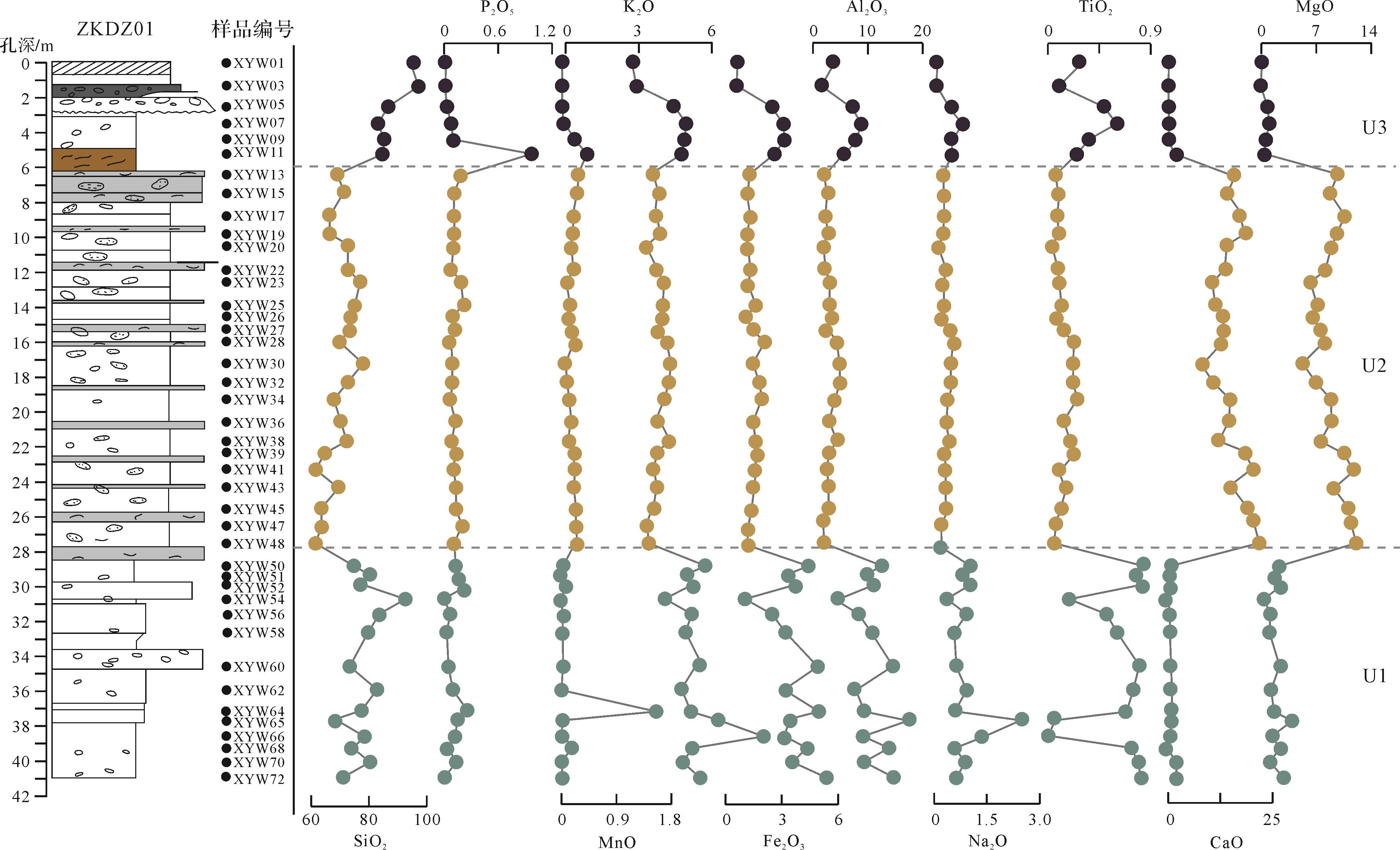
主量元素分析测试结果见表1,P2O5、MnO数值较为稳定,P2O5平均值为0.13%,除一个样品XYW11值为1.03%外,其余样品值稳定在0.01%~0.26%范围内;样品的MnO含量也较为稳定,除XYW64样品MnO含量为1.64%外,其余样品MnO值在0~0.41%范围内波动(平均值为0.15)。此外,SiO2、MgO、Al2O3、K2O、TiO2、CaO、Fe2O3和Na2O八个元素含量波动较大,呈现出明显的分段特征。以XYW11的编号样品为界,之上的U3段具有相对较高的SiO2、K2O、Fe2O3、Al2O3、Na2O、TiO2以及相对较低的MgO、CaO含量,编号在XYW12~XYW48之间的U2段样品,具有相对较低且稳定的K2O、Fe2O3、Al2O3、Na2O、TiO2含量,而MgO、CaO相对较高且波动较大。XYW48之下的U1段样品,SiO2、K2O、Fe2O3、Al2O3、Na2O、TiO2含量显著增加且波动变大(图3)。
表 1 ZKDZ01钻孔主量元素、Sr⁃Nd同位素特征
Table 1. Major elements and Sr⁃Nd isotopic characteristic for borehole ZKDZ01
样品编号 Na2O MgO Al2O3 P2O5 K2O CaO Fe2O3 TiO2 MnO SiO2 87Sr/86Sr ±2σ 143Nd/144Nd ±2σ XYW01 0.09 0.09 3.55 0.03 0.22 0.06 0.62 0.27 0.01 95.07 0.719 244 5.00 0.512 140 8.00 XYW03 0.09 0.10 1.55 0.01 0.36 0.05 0.59 0.11 0.01 97.13 XYW05 0.49 0.76 7.18 0.03 1.81 0.15 2.45 0.48 0.02 86.64 0.722 718 5.00 0.512 054 5.00 XYW07 0.79 1.01 8.73 0.08 2.38 0.21 3.05 0.59 0.02 83.15 XYW09 0.51 0.75 7.69 0.10 2.33 0.14 3.10 0.37 0.19 84.81 0.719 707 5.00 0.512 198 4.00 XYW11 0.48 0.69 5.75 1.03 2.21 1.53 2.67 0.26 0.41 84.97 0.718 421 6.00 0.512 131 7.00 XYW13 0.28 9.83 2.01 0.18 1.04 15.96 1.31 0.07 0.28 69.05 XYW15 0.28 8.87 2.54 0.11 1.23 14.08 1.16 0.10 0.26 71.38 0.713 591 5.00 0.512 155 3.00 XYW17 0.28 10.72 2.29 0.11 1.15 16.99 1.31 0.08 0.20 66.87 XYW19 0.28 9.73 2.57 0.11 1.28 18.20 1.15 0.09 0.19 66.41 0.713 560 5.00 0.512 149 3.00 XYW20 0.15 9.00 1.87 0.10 0.75 13.99 1.21 0.05 0.15 72.73 XYW22 0.33 8.14 2.58 0.09 1.25 13.15 1.31 0.09 0.15 72.91 XYW23 0.29 6.34 2.92 0.19 1.44 10.58 1.22 0.10 0.09 76.85 0.710 451 5.00 0.512 162 3.00 XYW25 0.28 7.01 3.00 0.22 1.41 11.53 1.55 0.11 0.11 74.79 XYW26 0.31 6.79 2.99 0.09 1.43 12.69 1.17 0.10 0.11 74.32 XYW27 0.41 7.44 2.84 0.11 1.34 13.25 1.35 0.11 0.14 73.01 0.710 517 4.00 0.512 146 3.00 XYW28 0.52 7.85 4.15 0.09 1.54 13.12 1.99 0.22 0.16 70.36 XYW30 0.51 5.37 4.65 0.09 1.77 8.02 1.49 0.23 0.07 77.80 XYW32 0.46 7.03 4.90 0.09 1.69 10.76 1.80 0.23 0.09 72.95 0.714 615 4.00 0.512 117 2.00 XYW34 0.42 8.97 3.87 0.08 1.50 14.80 1.89 0.25 0.12 68.10 XYW36 0.35 8.99 3.10 0.13 1.21 14.32 1.48 0.14 0.15 70.13 0.712 646 4.00 0.512 148 2.00 XYW38 0.44 7.59 4.23 0.09 1.61 11.95 1.59 0.20 0.12 72.19 0.711 724 4.00 0.512 140 3.00 XYW39 0.35 10.68 2.93 0.11 1.23 17.93 1.61 0.22 0.17 64.78 XYW41 0.32 11.89 2.50 0.11 1.06 20.24 1.58 0.10 0.22 61.97 XYW43 0.33 9.31 2.80 0.13 1.19 14.87 1.49 0.16 0.20 69.53 0.710 332 4.00 0.512 148 4.00 XYW45 0.34 11.32 2.68 0.13 1.08 19.20 1.37 0.12 0.23 63.53 XYW47 0.24 11.53 1.82 0.21 0.78 20.29 1.18 0.07 0.23 63.65 0.709 691 5.00 0.512 165 4.00 XYW48 0.21 12.25 1.81 0.11 0.86 21.75 1.15 0.06 0.25 61.55 XYW50 1.01 2.24 12.50 0.13 3.15 0.49 4.41 0.83 0.03 75.21 0.724 134 4.00 0.512 024 6.00 XYW51 0.81 1.87 9.87 0.16 2.44 0.61 3.39 0.77 0.02 80.05 XYW52 0.93 1.80 10.88 0.16 2.60 0.54 3.49 0.81 0.02 78.76 XYW54 0.39 0.55 4.19 0.02 1.59 0.17 1.11 0.19 0.01 91.78 0.722 898 4.00 0.512 076 9.00 XYW56 0.82 1.04 8.09 0.06 2.61 0.43 2.38 0.51 0.02 84.04 XYW58 0.65 1.52 10.27 0.05 2.48 0.46 3.08 0.59 0.02 80.88 XYW60 0.68 2.25 14.42 0.05 2.93 0.61 4.90 0.79 0.02 73.35 0.724 613 4.00 0.512 039 4.00 XYW62 0.81 1.37 8.27 0.11 2.19 0.73 3.12 0.73 0.02 82.64 0.721 658 5.00 0.512 019 7.00 XYW64 0.64 1.63 9.28 0.26 2.54 0.96 4.93 0.67 1.64 77.45 XYW65 2.41 3.87 17.26 0.15 3.66 0.84 3.43 0.06 0.01 68.30 XYW66 1.33 1.47 9.13 0.12 5.54 0.82 3.12 0.00 0.00 78.47 0.718 853 4.00 0.512 117 2.00 XYW68 0.62 1.91 13.33 0.09 2.64 0.49 4.29 0.72 0.12 75.79 0.725 757 4.00 0.512 038 4.00 XYW70 0.85 1.54 9.70 0.10 2.38 1.72 3.65 0.77 0.02 79.27 XYW72 0.63 2.58 14.56 0.04 2.86 1.47 5.21 0.79 0.03 71.82 0.723 219 4.00 0.512 007 4.00 注: 主量元素单位为%;空白处无测试数据。
图 3 ZKDZ01钻孔主量元素含量变化图
Figure 3. Variation of major element contents in borehole ZKDZ01
-
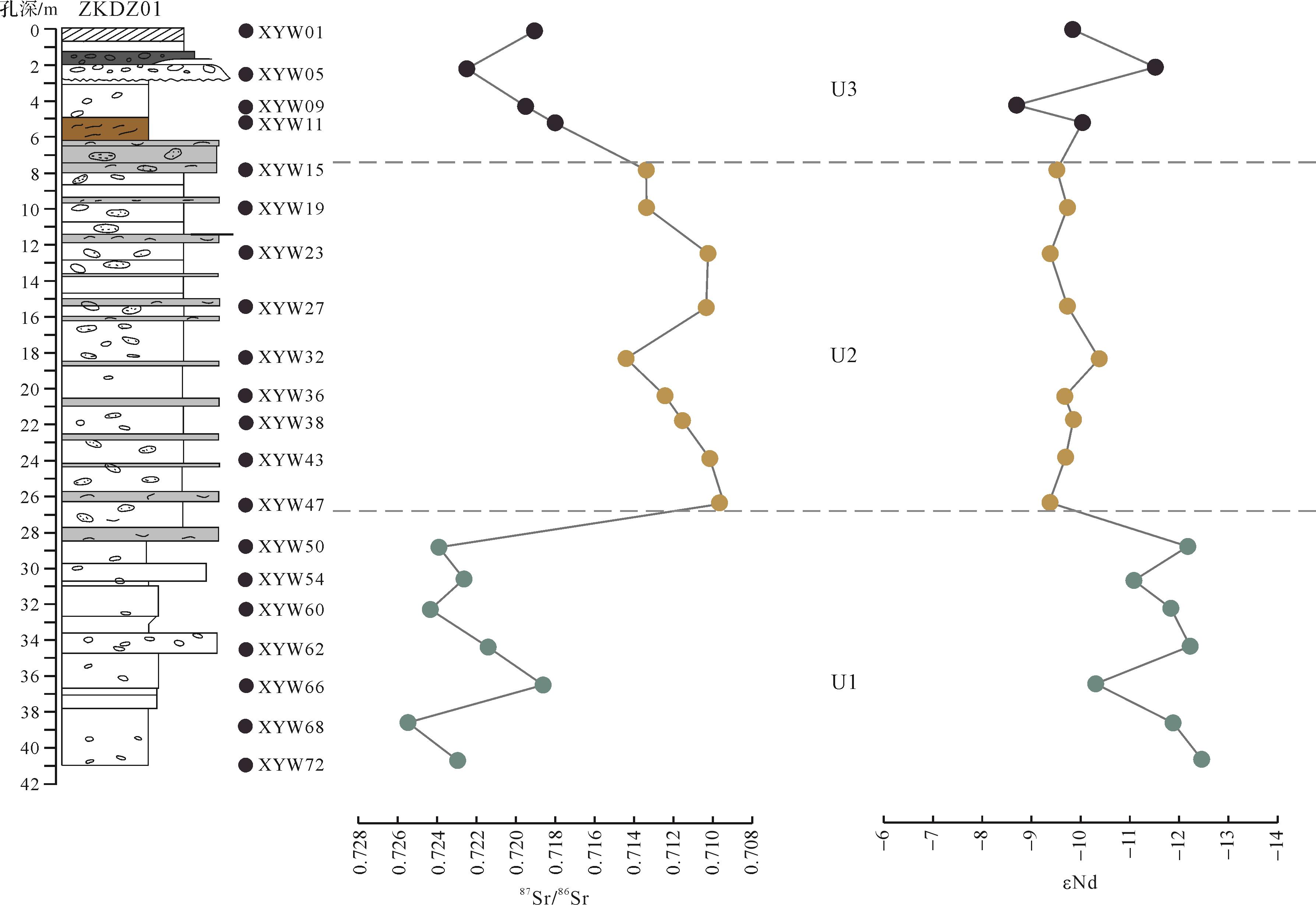
ZKDZ01钻孔的20个样品的87Sr/86Sr值在0.709 691~0.725 750范围内波动,平均值为0.717 234。其中U1段7个样品87Sr/86Sr值相对较高,介于0.718 853~0.725 75,平均值为0.723 019;U2段9个样品则整体呈现较低的87Sr/86Sr值,波动范围为0.709 691~0.714 615,平均值为0.712 068;U3段4个样品的87Sr/86Sr值有所升高,介于0.718 421~0.722 718,平均值为0.720 023(表1、图4)。

图 4 ZKDZ01钻孔Sr、Nd同位素变化曲线
Figure 4. Variation of Sr and Nd isotopes in borehole ZKDZ01
143Nd/144Nd值呈现与87Sr/86Sr值相反的变化曲线,整体在0.512 007和0.121 980之间变化,平均值为0.512 111,εNd(0)值介于-12.30~-8.58,平均值为-10.28。U1段143Nd/144Nd值和εNd(0)值相对最低,分别介于0.512 007~0.512 117(平均值为0.512 046)和-12.30~-10.16(平均值为-11.55);U2段143Nd/144Nd值则相对较高,介于0.512 148~0.512 165,平均值为0.512 149,εNd(0)值介于-10.16~-9.22,平均值为-9.55;U3段143Nd/144Nd值范围为0.512 054~0.512 198,平均值为0.512 131,εNd(0)值介于-11.39~-8.58,平均值为-9.89(图4)。
-
基于气候变化影响源区化学风化作用,导致沉积物中主量元素发生改变(Nesbitt and Young,1982;Johnsson et al.,1988;McLennan et al.,1993),具体表现为K、Mg等较为活泼的元素在岩石风化过程中流失,且易于被黏土矿物吸附,而Al等不活跃元素也容易富集在风化产物中(Weaver,1967;Nesbitt and Young,1982),使得风化产物中往往富集K、Mg和Al元素。Ti元素在源岩和风化产物中含量无明显差别,因此利用Al/Ti、K/Ti、Fe/Ti和Mg/Ti比值反映源区化学风化作用强度的变化,进而指示陆源区的气候变化。
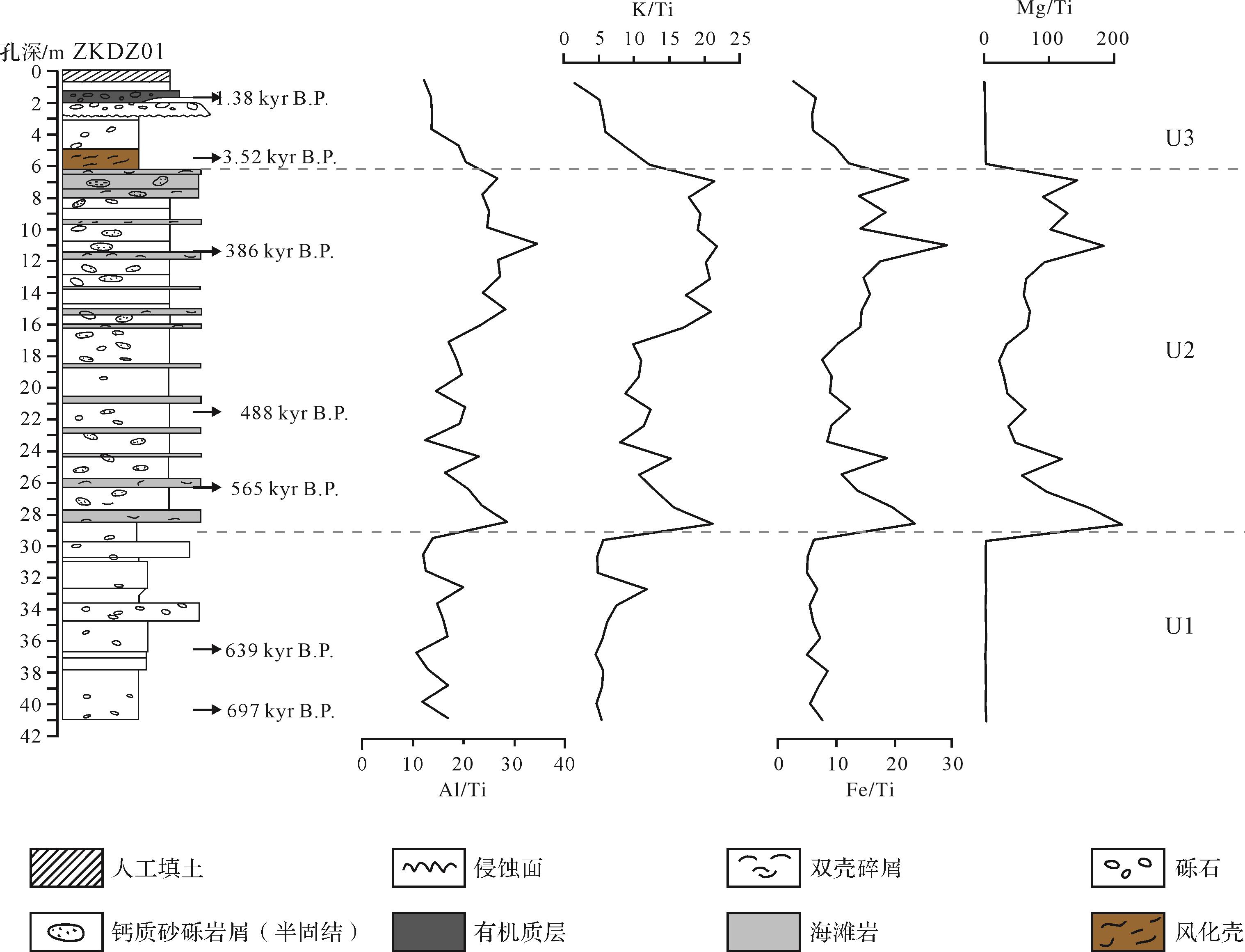
ZKDZ01钻孔U1段表现出Al/Ti、K/Ti、Fe/Ti、Mg/Ti的相对低值(图5),反映出干冷的沉积环境。U1段沉积时期约为700~600 ka,对应于南海中更新世气候转型过渡期,前人研究显示该时期冬季风不断增强,浮游有孔虫冷水种丰度骤增(郑范等,2006),深海氧同位素突然增加0.29‰(Mudelsee and Schulz,1997),全球冰量也增长15%(Berger et al.,1994)。此外,U1段沉积物中细粒组分含量相对较多(Zhu et al.,2026)(图2),表明在干旱的气候条件下,地表径流减少,水动力不足(Nádor et al.,2003;彭晓彤等,2004)。

图 5 ZKDZ01钻孔沉积物Al/Ti、K/Ti、Fe/Ti、Mg/Ti比值变化曲线
Figure 5. Variations in Al/Ti, K/Ti, Fe/Ti, Mg/Ti from borehole ZKDZ01
U2段沉积年龄约为600~300 ka,该段沉积物Al/Ti、K/Ti、Fe/Ti、Mg/Ti值升高(图5),表明温暖湿润的气候环境。对南海西部MD05-2899钻孔沉积地球化学研究显示540 ka以来东亚夏季风不断增强,导致中国南方气候极度湿润,降雨量增多(贺子丁等,2012)。地表径流的增加使得粗粒碎屑能搬运到新英湾地区(图2)。此外,海平面上涨导致新英湾由陆相转变为浅海沉积环境,新英湾及周缘地区均有该时期海滩岩出露(姚衍桃等,2009;禤宇添等,2022)(图5)。
晚更新世后,海南岛构造活动频繁,包括新英湾在内的海南岛北西部处于整体抬升状态,构造运动使不少海湾底部抬升为阶地(曹琼英,1986;张军龙等,2008),新英湾地区以剥蚀为主(张军龙等,2008),直到全新世海平面达到现今高度(Ma et al.,1999),新英湾开始沉积。U3段Al/Ti、K/Ti、Fe/Ti、Mg/Ti值降低(图5)且细粒组分含量增多(图2),表明气候相较于U2段沉积期更加干旱寒冷。
-
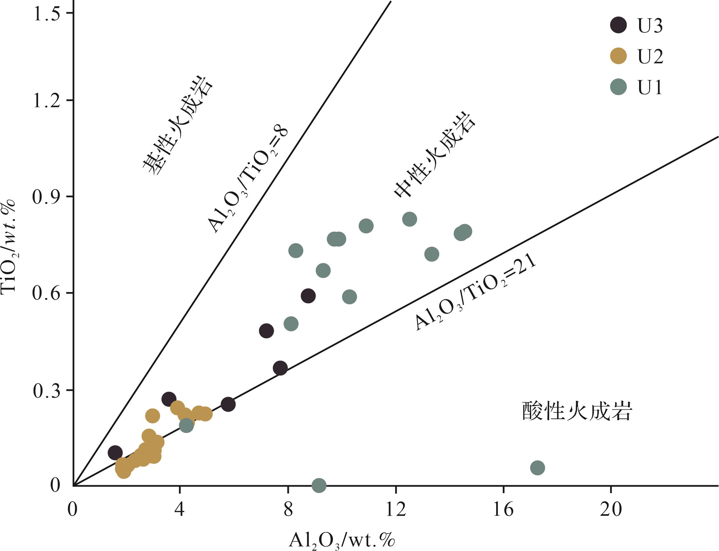
海南岛中部高四周低的地形有利于地表径流的物质剥蚀和搬运,春江、北门江作为汇入新英湾的两条主要河流,其流域面积分别为558 km2和648 km2(蔡廷禄等,2016),为新英湾及其周缘近海带来大量现代沉积物(田成静等,2013)。其次,华南大陆的沿岸流以及北部湾逆时针环流携带来自红河、珠江的物质,影响海南岛周缘海域的物质沉积,如海南岛西北的莺歌海盆地主要接受红河的物质输入(Clift and Sun,2006;Wang et al.,2014),中东部海域沉积物从珠江口盆地经沿岸流搬运(Liu et al.,2010;Cao et al.,2019)。在TiO2-Al2O3物源判别图解中,显示U1段沉积物大多来源于中性或酸性火成岩(图6);U2段沉积物沿中性火成岩和酸性火成岩分界线Al2O3/TiO2=21分布(图6),U3段沉积物大多来自中性火成岩区(图6)。

图 6 TiO2⁃Al2O3物源判别图解(Hayashi et al.,1997)
Figure 6. TiO2 versus Al2O3 diagram showing the provenance of borehole ZKDZ01 (Hayashi et al., 1997)
由于Nd元素多赋存于独居石和褐帘石(Garçon et al.,2014),而Sr元素是基性岩和典型大陆来源的良好指示剂(Asahara et al.,1999;Hemming et al.,2007),且Sr和Nd同位素在沉积物风化、搬运和分选过程中不容易被影响,因此二者的结合常用作指示沉积物来源。通常情况下,火山物质或者具有年轻模式年龄(TDM)的岩浆岩具有较高的Nd同位素值和较低的Sr同位素值;相反,高Sr同位素值和低Nd同位素值往往指示较老的大陆地壳物质(Li et al.,2003;Yan et al.,2007)。
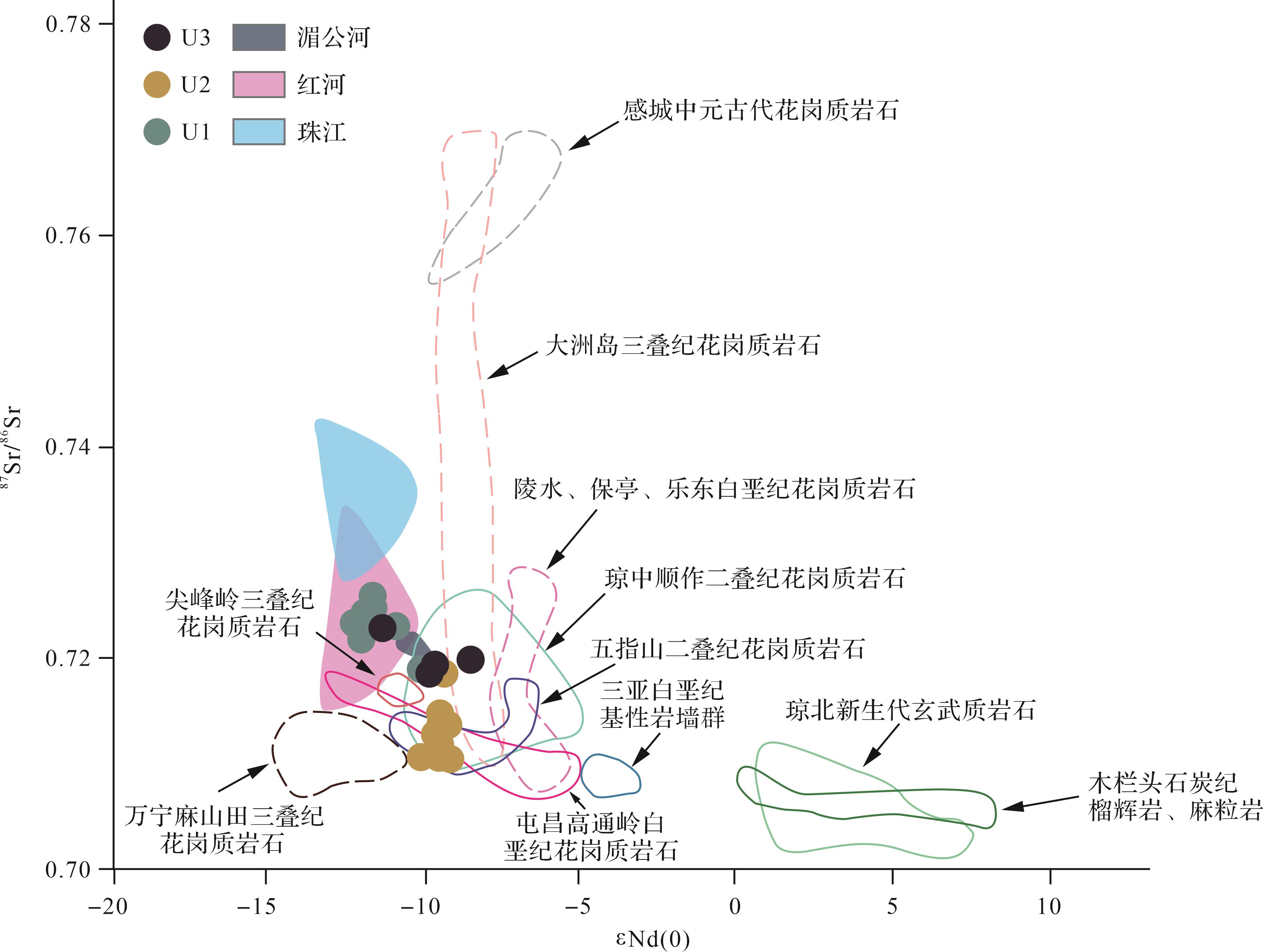
将ZKDZ01钻孔沉积物Sr-Nd同位素组成与海南岛不同地区、不同时代、不同岩性的源岩以及珠江、红河、湄公河现代沉积物Sr-Nd同位素组成进行对比(图7)(Liu et al.,2007;张磊等,2022)。结果显示,U1段沉积物具有相对较高的Sr同位素和较低的Nd同位素值(图7),表明该段沉积物来源于较老岩体。此外,U1段沉积物Sr-Nd同位素组成与红河现代沉积物相似,且不在海南岛内任一源岩分布范围内(图7),表明其沉积物可能来源于更加古老的印支或华南地块。这一结果与海南岛北部中更新统Sr-Nd同位素反映出的本地源区不同(张磊等,2022),推测是由于地理位置和地表径流差异引起,研究区位于海南岛西北部,地理位置更靠近印支大陆,其沉积物源易受红河影响(赵梦等,2013)。此外,南渡江作为海南岛最大河流,起源于海南岛中部白沙黎族自治县,其流域覆盖大部分琼北地区(李高聪等,2016),但并不涵盖西北部的新英湾及周缘区域,这一特征使得中部白垩纪—二叠纪花岗岩风化剥蚀物质更易于搬运至海南岛北部而非新英湾。U2、U3段沉积物相对较高的Nd同位素和较低的Sr同位素值表明物质来源于更加年轻的岩体。U2段沉积物Sr-Nd同位素组成与五指山二叠纪花岗岩、琼中顺作二叠纪花岗岩以及屯昌高通岭白垩纪花岗质岩石相似(图7);U3段沉积物Sr-Nd同位素组成分布在琼中顺作二叠纪花岗质岩石范围内(图7),这一结果表明U2、U3段沉积物主要来自海南岛中部白垩纪、二叠纪花岗质岩石。

图 7 ZKDZ01钻孔沉积物87Sr/86Sr⁃εNd(0)判别图解(Liu et al.,2007;张磊等,2022)
Figure 7. 87Sr/86Sr versus εNd(0) plots for source rock discrimination of the borehole ZKDZ01 (Liu et al., 2007;Zhang et al., 2022)
-
U1段沉积年龄约为700~600 ka(Zhu et al.,2026),该时期青藏高原可能隆升到海拔3 000 m左右,印度洋输送至亚洲内陆的水汽减少导致内陆干旱化加剧(张明强等,2010)。这一干旱事件在中国黄土高原、塔克拉玛干沙漠等地均有记录(Ding et al.,1994;方小敏等,2001,2002)。该时期对应北半球最冷的MIS16期,全球冰量增长15%(Berger et al.,1994),这一干冷的气候特征使得U1段沉积物Al/Ti、K/Ti、Fe/Ti、Mg/Ti值相对较低(图5)。此外,古地理重建表明,巽他陆架在该时期海平面至少比现今低135 m(Robles et al.,2015),我国沿海出现海平面大幅度降低的情况(汪品先,1995;邬光剑等,2002),新英湾U1段表现出以河流相为特征的淡水或海陆交互相沉积环境(图2)。同时,较低的海平面使得印支大陆较古老的碎屑沉积物能通过红河或相关支流输送至新英湾,使U1段沉积物Sr-Nd同位素组成呈现与红河现代沉积物相似的特征(图7)。
600 ka后,东亚夏季风强度不断提高(贺子丁等,2012),U2段沉积物记录的新英湾地区气候由寒冷干燥向温暖湿润转变(图5)。此外,新英湾地区海平面上升,U2段沉积物沉积于海洋环境(图2),出现海滩岩等海相特征沉积。海平面的上升阻碍了印支地块碎屑沉积物向新英湾的输入,U2段沉积物物源区以海南岛内五指山二叠纪花岗岩、琼中顺作二叠纪花岗岩以及屯昌高通岭白垩纪花岗质岩石为主(图7)。
晚更新世时期,新英湾受内外营力的强烈作用,新构造运动导致新英湾及其邻近地区差异性抬升,加之受全球冰期气候影响,全球海平面大幅度下降,在6.8~5.8 ka达到现今高度(邬光剑等,2002),琼北地区也在晚更新世—全新世持续海退(梁定勇等,2018),地表水流的侵蚀作用和搬运能力增强,使海湾及其毗邻地区的上更新统地层普遍缺失(林国尧和李文欢,2009)。研究区U3段全新统沉积物超覆在中更新统U2段上,为淡水或海陆交互相沉积环境,源区以岛内五指山二叠纪花岗质岩石为主(图7)。
-
(1) 新英湾ZKDZ01钻孔沉积物以2 854 cm和620 cm为界,地球化学特征自下而上分为U1、U2和U3段。底部U1段具有较低εNd(0)值和较高的86Sr/87Sr值,中部U2段具有较高的Al/Ti、K/Ti、Fe/Ti、Mg/Ti值。
(2) U1段Sr-Nd同位素比值显示沉积物来源于古老陆块的剥蚀,且Sr-Nd同位素比值与现代红河沉积物相似。U2、U3段沉积物Sr-Nd同位素比值则与海南岛中部的白垩纪、二叠纪花岗岩相似。环境特征元素比显示新英湾更新世以来气候经历了相对干冷—湿热—干冷的转变。
(3) 沉积物源的变化可能与中更新世气候转型以及晚更新世海南岛区域构造活动有关。
The Provenance and Paleoenvironment Significance of Xinying Bay in Hainan Since the Pleistocene
-
摘要: 目的 海南新英湾保留了更新世以来相对完整的海相地层沉积记录,且由于其封闭性以及稳定性,成为反演南海北部更新世以来环境变化的良好窗口。 方法 对新英湾南岸获取的地质钻孔进行了全岩主量元素、Sr-Nd同位素地球化学分析,重建了这一区域更新世以来沉积物物质来源以及古气候、古环境演化过程,并探讨了其驱动机制。 结果 钻孔自下而上具有较为明显的三段特征,底部U1段具有较低εNd(0)值和较高的87Sr/86Sr值,中部U2段具有较高的Al/Ti、K/Ti、Fe/Ti、Mg/Ti值。物源分析结果表明,钻孔沉积物来源于中酸性源区,底部U1段含较多古老的沉积物质,且Sr-Nd同位素比值与红河沉积物相似,U2、U3段沉积物则与海南岛内白垩纪、二叠纪长英质花岗岩相似。古环境分析显示这一区域更新世以来经历了寒冷—暖湿—干冷的气候变化过程。 结论 结合前人年代学研究,U1段对应北半球最冷的MIS16期,干冷的气候且较低的海平面使得印支大陆碎屑沉积物能输送至新英湾。随后东亚夏季风增强,气候由寒冷干燥向温暖湿润转变,海平面上升导致U2段源区以海南岛内花岗质岩石为主。U3段经历区域构造抬升,沉积源区以岛内花岗岩为主。Abstract: Objective Xinying Bay, Hainan province, has retained a relatively complete sedimentary record of marine stratigraphy since the Pleistocene. Owing to its closure and stability, it serves as a good window to reflect the paleoenvironmental changes since the Pleistocene in the northern South China Sea. Methods Based on the analysis of whole rock major elements and Sr-Nd isotopes, the source of sediment material and the evolution of paleoclimate in this area since the Pleistocene were reconstructed, and the driving mechanism was discussed. Results The borehole has three sections from bottom to top. The bottom section, U1, has a relatively low εNd(0) value and a relatively high 86Sr/87Sr value. The middle section, U2, has relatively high ratios of Al/Ti, K/Ti, Fe/Ti, and Mg/Ti. The results of provenance analysis show that the sediments of the borehole come from the intermediate source area, and the U1 section contains more older sedimentary materials, and the Sr-Nd isotope ratio is similar to that of the Red river sediments, whereas U2 and U3 are similar to the Cretaceous-Permian feldspar granite in Hainan Island. The paleo-environmental analysis shows that this region has experienced changes from dry cold to warm wet, and then to dry cold since the Pleistocene. Conclusions The sedimentary period of section U1 corresponds to the coldest period, MIS16, in the Northern Hemisphere, which combined with previous chronological studies, the dry and cold climate, and relatively low sea level, enable the clastic sediments of the Indochina continent to be transported to Xinying Bay. Then, the East Asian summer monsoon strengthened, and the climate changed from cold and dry to warm and humid. As a result, the source area of U2 was dominated by granitic rocks in Hainan Island because the sea level increased. U3 has undergone regional tectonic uplift, and the sedimentary source area is dominated by granite in the island.
-
Key words:
- Xinying Bay /
- Pleistocene /
- provenance /
- paleoenvironment /
- sedimentary geochemistry
-
图 1 (a)海南岛区域地质图(张磊等,2022);(b)新英湾ZKDZ01钻孔位置图(Zhu et al.,2026)
Figure 1. (a) Regional geological map of Hainan Island (Zhang et al., 2022); (b) location of borehole ZKDZ01 in Xinying Bay (Zhu et al., 2026)
图 2 ZKDZ01钻孔综合柱状图(Zhu et al.,2026)
Figure 2. Stratigraphic columns of borehole ZKDZ01 (Zhu et al., 2026)
图 3 ZKDZ01钻孔主量元素含量变化图
Figure 3. Variation of major element contents in borehole ZKDZ01
图 5 ZKDZ01钻孔沉积物Al/Ti、K/Ti、Fe/Ti、Mg/Ti比值变化曲线
Figure 5. Variations in Al/Ti, K/Ti, Fe/Ti, Mg/Ti from borehole ZKDZ01
图 6 TiO2⁃Al2O3物源判别图解(Hayashi et al.,1997)
Figure 6. TiO2 versus Al2O3 diagram showing the provenance of borehole ZKDZ01 (Hayashi et al., 1997)
图 7 ZKDZ01钻孔沉积物87Sr/86Sr⁃εNd(0)判别图解(Liu et al.,2007;张磊等,2022)
Figure 7. 87Sr/86Sr versus εNd(0) plots for source rock discrimination of the borehole ZKDZ01 (Liu et al., 2007;Zhang et al., 2022)
表 1 ZKDZ01钻孔主量元素、Sr⁃Nd同位素特征
Table 1. Major elements and Sr⁃Nd isotopic characteristic for borehole ZKDZ01
样品编号 Na2O MgO Al2O3 P2O5 K2O CaO Fe2O3 TiO2 MnO SiO2 87Sr/86Sr ±2σ 143Nd/144Nd ±2σ XYW01 0.09 0.09 3.55 0.03 0.22 0.06 0.62 0.27 0.01 95.07 0.719 244 5.00 0.512 140 8.00 XYW03 0.09 0.10 1.55 0.01 0.36 0.05 0.59 0.11 0.01 97.13 XYW05 0.49 0.76 7.18 0.03 1.81 0.15 2.45 0.48 0.02 86.64 0.722 718 5.00 0.512 054 5.00 XYW07 0.79 1.01 8.73 0.08 2.38 0.21 3.05 0.59 0.02 83.15 XYW09 0.51 0.75 7.69 0.10 2.33 0.14 3.10 0.37 0.19 84.81 0.719 707 5.00 0.512 198 4.00 XYW11 0.48 0.69 5.75 1.03 2.21 1.53 2.67 0.26 0.41 84.97 0.718 421 6.00 0.512 131 7.00 XYW13 0.28 9.83 2.01 0.18 1.04 15.96 1.31 0.07 0.28 69.05 XYW15 0.28 8.87 2.54 0.11 1.23 14.08 1.16 0.10 0.26 71.38 0.713 591 5.00 0.512 155 3.00 XYW17 0.28 10.72 2.29 0.11 1.15 16.99 1.31 0.08 0.20 66.87 XYW19 0.28 9.73 2.57 0.11 1.28 18.20 1.15 0.09 0.19 66.41 0.713 560 5.00 0.512 149 3.00 XYW20 0.15 9.00 1.87 0.10 0.75 13.99 1.21 0.05 0.15 72.73 XYW22 0.33 8.14 2.58 0.09 1.25 13.15 1.31 0.09 0.15 72.91 XYW23 0.29 6.34 2.92 0.19 1.44 10.58 1.22 0.10 0.09 76.85 0.710 451 5.00 0.512 162 3.00 XYW25 0.28 7.01 3.00 0.22 1.41 11.53 1.55 0.11 0.11 74.79 XYW26 0.31 6.79 2.99 0.09 1.43 12.69 1.17 0.10 0.11 74.32 XYW27 0.41 7.44 2.84 0.11 1.34 13.25 1.35 0.11 0.14 73.01 0.710 517 4.00 0.512 146 3.00 XYW28 0.52 7.85 4.15 0.09 1.54 13.12 1.99 0.22 0.16 70.36 XYW30 0.51 5.37 4.65 0.09 1.77 8.02 1.49 0.23 0.07 77.80 XYW32 0.46 7.03 4.90 0.09 1.69 10.76 1.80 0.23 0.09 72.95 0.714 615 4.00 0.512 117 2.00 XYW34 0.42 8.97 3.87 0.08 1.50 14.80 1.89 0.25 0.12 68.10 XYW36 0.35 8.99 3.10 0.13 1.21 14.32 1.48 0.14 0.15 70.13 0.712 646 4.00 0.512 148 2.00 XYW38 0.44 7.59 4.23 0.09 1.61 11.95 1.59 0.20 0.12 72.19 0.711 724 4.00 0.512 140 3.00 XYW39 0.35 10.68 2.93 0.11 1.23 17.93 1.61 0.22 0.17 64.78 XYW41 0.32 11.89 2.50 0.11 1.06 20.24 1.58 0.10 0.22 61.97 XYW43 0.33 9.31 2.80 0.13 1.19 14.87 1.49 0.16 0.20 69.53 0.710 332 4.00 0.512 148 4.00 XYW45 0.34 11.32 2.68 0.13 1.08 19.20 1.37 0.12 0.23 63.53 XYW47 0.24 11.53 1.82 0.21 0.78 20.29 1.18 0.07 0.23 63.65 0.709 691 5.00 0.512 165 4.00 XYW48 0.21 12.25 1.81 0.11 0.86 21.75 1.15 0.06 0.25 61.55 XYW50 1.01 2.24 12.50 0.13 3.15 0.49 4.41 0.83 0.03 75.21 0.724 134 4.00 0.512 024 6.00 XYW51 0.81 1.87 9.87 0.16 2.44 0.61 3.39 0.77 0.02 80.05 XYW52 0.93 1.80 10.88 0.16 2.60 0.54 3.49 0.81 0.02 78.76 XYW54 0.39 0.55 4.19 0.02 1.59 0.17 1.11 0.19 0.01 91.78 0.722 898 4.00 0.512 076 9.00 XYW56 0.82 1.04 8.09 0.06 2.61 0.43 2.38 0.51 0.02 84.04 XYW58 0.65 1.52 10.27 0.05 2.48 0.46 3.08 0.59 0.02 80.88 XYW60 0.68 2.25 14.42 0.05 2.93 0.61 4.90 0.79 0.02 73.35 0.724 613 4.00 0.512 039 4.00 XYW62 0.81 1.37 8.27 0.11 2.19 0.73 3.12 0.73 0.02 82.64 0.721 658 5.00 0.512 019 7.00 XYW64 0.64 1.63 9.28 0.26 2.54 0.96 4.93 0.67 1.64 77.45 XYW65 2.41 3.87 17.26 0.15 3.66 0.84 3.43 0.06 0.01 68.30 XYW66 1.33 1.47 9.13 0.12 5.54 0.82 3.12 0.00 0.00 78.47 0.718 853 4.00 0.512 117 2.00 XYW68 0.62 1.91 13.33 0.09 2.64 0.49 4.29 0.72 0.12 75.79 0.725 757 4.00 0.512 038 4.00 XYW70 0.85 1.54 9.70 0.10 2.38 1.72 3.65 0.77 0.02 79.27 XYW72 0.63 2.58 14.56 0.04 2.86 1.47 5.21 0.79 0.03 71.82 0.723 219 4.00 0.512 007 4.00 注: 主量元素单位为%;空白处无测试数据。 下载: 导出CSV
-
[1] 蔡廷禄,倪建宇,贾建军,等. 2016. 海南岛典型港湾沉积物化学特征及重金属污染评价[J]. 第四纪研究,36(1):93-102. Cai Tinglu, Ni Jianyu, Jia Jianjun, et al. 2016. The characteristics of chemical parameters and the pollution evaluation of heavy metals in surficial sediments of four typical bays, Hainan province[J]. Quaternary Sciences, 36(1): 93-102. [2] 曹琼英. 1986. 海南岛西北岸三万年前后浅海相地层的发现及其意义[J]. 南京大学学报(自然科学版),22(3):545-550. Cao Qiong-ying. 1986. Marine strata around coast of northwest part of Hainan Island[J]. Journal of Nanjing University (Natural Sciences), 22(3): 545-550. [3] 方小敏,吕连清,杨胜利,等. 2001. 昆仑山黄土与中国西部沙漠发育和高原隆升[J]. 中国科学:地球科学,31(3):177-184. Fang Xiaomin, Lianqing Lü, Yang Shengli, et al. 2001. Loess in Kunlun Mountains and its implications on desert development and Tibetan Plateau uplift in west China[J]. Science China Earth Sciences, 31(3): 177-184. [4] 方小敏,史正涛,杨胜利,等. 2002. 天山黄土和古尔班通古特沙漠发育及北疆干旱化[J]. 科学通报,47(7):540-545. Fang Xiaomin, Shi Zhengtao, Yang Shengli, et al. 2002. Loess in the Tian Shan and its implications for the development of the Gurbantunggut desert and drying of northern Xinjiang[J]. Chinese Science Bulletin, 47(7): 540-545. [5] 贺子丁,刘志飞,李建如,等. 2012. 南海西部54万年以来元素地球化学记录及其反映的古环境演变[J]. 地球科学进展,27(3):327-336. He Ziding, Liu Zhifei, Li Jianru, et al. 2012. Elemental geochemical records in the western South China Sea since 540 ka and their paleoenvironmental implications[J]. Advances in Earth Science, 27(3): 327-336. [6] 李高聪,高抒,戴晨. 2016. 海南岛主要入海河流流域地貌演化[J]. 第四纪研究,36(1):121-130. Li Gaocong, Gao Shu, Dai Chen. 2016. Geomorphological evolution of major catchment basins of Hainan Island, southern China[J]. Quaternary Sciences, 36(1): 121-130. [7] 梁定勇,李孙雄,魏昌欣,等. 2018. 海南岛西南部全新世海滩岩地球化学特征及其古气候意义[J]. 地层学杂志,42(1):108-116. Liang Dingyong, Li Sunxiong, Wei Changxin, et al. 2018. Geochemical characteristics of Holocene beach rocks in southwestern Hainan Island and their paleoclimatic implications[J]. Journal of Stratigraphy, 42(1): 108-116. [8] 梁定勇,许国强,肖瑶,等. 2021. 海口江东新区新近纪—第四纪标准地层与组合分区[J]. 科学技术与工程,21(26):11052-11063. Liang Dingyong, Xu Guoqiang, Xiao Yao, et al. 2021. Neogene-Quaternary stratigraphic standard and combined zoning of Haikou Jiangdong new district[J]. Science Technology and Engineering, 21(26): 11052-11063. [9] 林国尧,李文欢. 2009. 洋浦湾—新英湾地质及洋浦深槽的形成与演变[J]. 海洋开发与管理,26(4):68-71. Lin Guoyao, Li Wenhuan. 2009. The geology of Yangpu Bay-Xinying Bay and the formation and evolution of Yangpu deep trough[J]. Ocean Development and Management, 26(4): 68-71. [10] 林义华,梁定勇,魏昌欣,等. 2023. 海南岛西北部晚更新世海滩岩地球化学特征及其古环境意义[J]. 科学技术与工程,23(10):4079-4090. Lin Yihua, Liang Dingyong, Wei Changxin, et al. 2023. Geochemical characteristics of Late Pleistocene beach rocks in northwest Hainan Island and their paleoenvironment implications[J]. Science Technology and Engineering, 23(10): 4079-4090. [11] 彭晓彤,周怀阳,叶瑛,等. 2004. 珠江河口沉积物粒度特征及其对底层水动力环境的指示[J]. 沉积学报,22(3):487-493. Peng Xiaotong, Zhou Huaiyang, Ye Ying, et al. 2004. Characteristics of sediment grain size and their implications for bottom hydrodynamic environment in the Pearl River estuary[J]. Acta Sedimentologica Sinica, 22(3): 487-493. [12] 孙倩文,黄康有,谢德豪,等. 2019. 海南岛三亚湾全新世以来沉积特征与古环境演变[J]. 中山大学学报(自然科学版),58(3):13-21. Sun Qianwen, Huang Kangyou, Xie Dehao, et al. 2019. On the sedimentary environment change since Holocene in the Sanya Bay, Hainan Island[J]. Acta Scientiarum Naturalium Universitatis Sunyatseni, 58(3): 13-21. [13] 田成静,欧阳婷萍,朱照宇,等. 2013. 海南岛周边海域表层沉积物磁化率空间分布特征及其物源指示意义[J]. 热带地理,33(6):666-673. Tian Chengjing, Ouyang Tingping, Zhu Zhaoyu, et al. 2013. Spatial distribution of magnetic susceptibility and its pro-venance implication of surface sediments in the sea areas around the Hainan Island[J]. Tropical Geography, 33(6): 666-673. [14] 王建华,夏法,邹和平. 1995. 海南岛排浦现代白云岩若干特征及其岩化作用探讨[J]. 热带海洋,14(3):16-22. Wang Jianhua, Xia Fa, Zou Heping. 1995. An approach to some characteristics and dolomitization of recent dolomite of Paipu, Hainan Island[J]. Tropic Oceanology, 14(3): 16-22. [15] 王梦媛,郑卓,黄康有,等. 2016. 海南岛南部MIS-5海相沉积地层的发现及其意义[J]. 热带地理,36(3):399-405,416. Wang Mengyuan, Zheng Zhuo, Huang Kangyou, et al. 2016. New insight on the marine deposit in the southern Hainan Island[J]. Tropical Geography, 36(3): 399-405, 416. [16] 汪品先. 1995. 西太平洋边缘海对我国冰期干旱化影响的初步探讨[J]. 第四纪研究,15(1):32-42. Wang Pinxian. 1995. The role of west pacific marginal seas in glacial aridification of China: A preliminary study[J]. Quaternary Sciences, 15(1): 32-42. [17] 魏雨秋,胡雅婷,周炼,等. 2023. 动态多接收TIMS方法高精度测定岩石标准物质的锶同位素组成[J]. 岩矿测试,42(5):944-956. Wei Yuqiu, Hu Yating, Zhou Lian, et al. 2023. High precision strontium isotope measurement of rock standard materials by multi-dynamic TIMS[J]. Rock and Mineral Analysis, 42(5): 944-956. [18] 邬光剑,潘保田,管清玉,等. 2002. 中更新世全球最大冰期与中国沙漠扩张[J]. 冰川冻土,24(5):544-549. Wu Guangjian, Pan Baotian, Guan Qingyu, et al. 2002. The maximum glaciation and desert expansion in China during MIS16[J]. Journal of Glaciology and Geocryology, 24(5): 544-549. [19] 禤宇添,詹文欢,姚衍桃,等. 2022. 海南岛西北部更新世海相地层的石英ESR测年探讨[J]. 海洋地质与第四纪地质,42(3):123-132. Xuan Yutian, Zhan Wenhuan, Yao Yantao, et al. 2022. Testing of quartz ESR dating for the marine strata on the northwestern coast of Hainan Island[J]. Marine Geology & Quaternary Geology, 42(3): 123-132. [20] 姚衍桃,詹文欢,孙金龙,等. 2009. 海南岛西北部莲花山周缘海相地层的区内对比及意义[J]. 海洋地质与第四纪地质,29(3):43-51. Yao Yantao, Zhan Wenhuan, Sun Jinlong, et al. 2009. Correlation and implication of marine strata around Lianhua Mountain in northwest Hainan Island[J]. Marine Geology & Quaternary Ge-ology, 29(3): 43-51. [21] 张军龙,田勤俭,李峰,等. 2008. 海南岛北西部新构造特征及其演化研究[J]. 地震,28(3):85-94. Zhang Junlong, Tian Qinjian, Li Feng, et al. 2008. Study on neotectonic characteristics and its evolution in northwestern Hainan Island[J]. Earthquake, 28(3): 85-94. [22] 张磊,麦发海,王超群,等. 2022. 海南岛北部晚新生代沉积物Sr-Nd同位素组成及其物源示踪[J]. 地质通报,41(11):1996-2006. Zhang Lei, Fahai Mai, Wang Chaoqun, et al. 2022. Sr-Nd isotopic composition and provenance tracing of Late Cenozoic sediments in the northern Hainan Island[J]. Geological Bulletin of China, 41(11): 1996-2006. [23] 张立敏,王岳军,张玉芝,等. 2017. 海南岛北部古生界时代:碎屑锆石U-Pb年代学约束[J]. 吉林大学学报(地球科学版),47(4):1187-1206. Zhang Limin, Wang Yuejun, Zhang Yuzhi, et al. 2017. Age of Paleozoic strata in northern Hainan Island: Constraints from the detrital zircon U-Pb geochronology[J]. Journal of Jilin University (Earth Science Edition), 47(4): 1187-1206. [24] 张明强,朱丽东,姜永见,等. 2010. 九江JL红土剖面记录的中更新世气候转型事件[J]. 海洋地质与第四纪地质,30(6):115-123. Zhang Mingqiang, Zhu Lidong, Jiang Yongjian, et al. 2010. Mid-Pleistocene climate transition event recorded by JL red earth section, Jiujiang, Jiangxi province[J]. Marine Geology & Quaternary Geology, 30(6): 115-123. [25] 张明书. 1990. 海南排浦海相第四纪与上新世界限的发现及白云石化作用问题[J]. 海洋地质与第四纪地质,10(1):47-59. Zhang Mingshu. 1990. A new discovery on Paipu of Hainan: Boundary between marine Quaternary and Pliocene and age of dolomitization[J]. Marine Geology & Quaternary Geology, 10(1): 47-59. [26] 张振克,孟红明,谢丽,等. 2010. 海南岛东寨港红树林区岩芯地球化学特征及其古地震指示[J]. 地理科学,30(5):777-782. Zhang Zhenke, Meng Hongming, Xie Li, et al. 2010. Geochemical records and its paleoearthquake significance of core sediments in Dongzhai Bay, Hainan Island, China[J]. Scientia Geographica Sinica, 30(5): 777-782. [27] 赵梦,邵磊,梁建设,等. 2013. 古红河沉积物稀土元素特征及其物源指示意义[J]. 地球科学:中国地质大学学报,38(增刊1):61-69. Zhao Meng, Shao Lei, Liang Jianshe, et al. 2013. REE character of sediment from the paleo-red river and its implication of pro-venance[J]. Earth Science: Journal of China University of Geo-sciences, 38(Suppl. 1): 61-69. [28] 郑范,李前裕,陈木宏. 2006. 南海北部1144站中更新世浮游有孔虫的千年尺度古气候记录[J]. 地球科学:中国地质大学学报,31(6):780-786. Zheng Fan, Li Qianyu, Chen Muhong. 2006. A millennial scale mid-Pleistocene paleoclimate record of planktonic foraminifera from the northern South China Sea site 1144[J]. Earth Science: Journal of China University of Geosciences, 31(6): 780-786. [29] 郑志锋,秦菡,宋家伟,等. 2022. 海南岛海岸带地质环境调查评价与监测(2022年度)成果报告[R]. 海南:海南省海洋地质调查研究院. Zheng Zhifeng, Qin Han, Song Jiawei, et al. 2022. Results report of geological environment survey, evaluation and monitoring of Hainan Island coastal zone (2022)[R]. Hainan: Hainan Institute of Marine Geological Survey. [30] Asahara Y, Tanaka T, Kamioka H, et al. 1999. Provenance of the north Pacific sediments and process of source material transport as derived from Rb–Sr isotopic systematics[J]. Chemical Geology, 158(3/4): 271-291. [31] Berger W H, Yasuda M K, Bickert T, et al. 1994. Quaternary time scale for the Ontong Java Plateau: Milankovitch template for Ocean Drilling Program Site 806[J]. Geology, 22(5): 463-467. [32] Cao L, Liu J G, Shi X F, et al. 2019. Source-to-sink processes of fluvial sediments in the northern South China Sea: Constraints from river sediments in the coastal region of South China[J]. Journal of Asian Earth Sciences, 185: 104020. [33] Chen J, Wang Z H, Chen Z Y, et al. 2009. Diagnostic heavy minerals in Plio–Pleistocene sediments of the Yangtze coast, China with special reference to the Yangtze River connection into the sea[J]. Geomorphology, 113(3/4): 129-136. [34] Clift P D, Sun Z. 2006. The sedimentary and tectonic evolution of the Yinggehai–Song Hong Basin and the southern Hainan margin, South China Sea: Implications for Tibetan uplift and monsoon intensification[J]. Journal of Geophysical Research: Solid Earth, 111(B6): B06405. [35] Ding Z, Yu Z, Rutter N W, et al. 1994. Towards an orbital time scale for Chinese loess deposits[J]. Quaternary Science Reviews, 13(1): 39-70. [36] Garçon M, Chauvel C, France-Lanord C, et al. 2014. Which minerals control the Nd–Hf–Sr–Pb isotopic compositions of river sediments?[J]. Chemical Geology, 364: 42-55. [37] Hayashi K I, Fujisawa H, Holland H D, et al. 1997. Geochemistry of ∼1.9 Ga sedimentary rocks from northeastern Labrador, Canada[J]. Geochimica Et Cosmochimica Acta, 61(19): 4115-4137. [38] He H Y, Wang Y J, Cawood P A, et al. 2020. Permo–Triassic granitoids, Hainan Island, link to Paleotethyan not Paleopacific tectonics[J]. GSA Bulletin, 132(9/10): 2067-2083. [39] Hemming S R, van de Flierdt T, Goldstein S L, et al. 2007. Strontium isotope tracing of terrigenous sediment dispersal in the Antarctic Circumpolar Current: Implications for constraining frontal positions[J]. Geochemistry, Geophysics, Geosystems, 8(6): Q06N13. [40] Johnsson M J, Stallard R F, Meade R H. 1988. First-cycle quartz arenites in the Orinoco River Basin, Venezuela and Colombia[J]. The Journal of Geology, 96(3): 263-277. [41] Li X H, Wei G J, Shao L, et al. 2003. Geochemical and Nd isotopic variations in sediments of the South China Sea: A response to Cenozoic tectonism in SE Asia[J]. Earth and Planetary Science Letters, 211(3/4): 207-220. [42] Li X H, Zhou H W, Chung S L, et al. 2002. Geochemical and Sm–Nd isotopic characteristics of metabasites from central Hainan Island, South China and their tectonic significance[J]. Island Arc, 11(3): 193-205. [43] Li Z X, Li X H, Li W X, et al. 2008. Was cathaysia part of Proterozoic Laurentia?: New data from Hainan Island, South China[J]. Terra Nova, 20(2): 154-164. [44] Ling Y, Tang W K, Wang Y, et al. 2020. Evidence of abrupt climate change during the mid- to Late-Holocene recorded in a tropical lake, southern China[J]. Acta Geologica Sinica, 94(4): 1187-1193. [45] Liu J G, Chen Z, Chen M H, et al. 2010. Magnetic susceptibility variations and provenance of surface sediments in the South China Sea[J]. Sedimentary Geology, 230(1/2): 77-85. [46] Liu Z F, Colin C, Huang W, et al. 2007. Climatic and tectonic controls on weathering in South China and Indochina peninsula: Clay mineralogical and geochemical investigations from the Pearl, Red, and Mekong drainage basins[J]. Geochemistry, Geophysics, Geo-systems, 8(5): Q05005. [47] Ma Z B, Xia M, Zhang C H, et al. 1999. High-precision U-series dating of Holocene corals from South China Sea by thermal ionization mass spectrometry (TIMS)[J]. Chinese Science Bulletin, 44(10): 937-941. [48] McLennan S M, Hemming S, McDaniel D K, et al. 1993. Geochemical approaches to sedimentation, provenance, and tectonics[J]. Special Papers-Geological Society of America: 21-21. [49] Mudelsee M, Schulz M. 1997. The mid-Pleistocene climate transition: Onset of 100 ka cycle lags ice volume build-up by 280 ka[J]. Earth and Planetary Science Letters, 151(1/2): 117-123. [50] Nádor A, Lantos M, Tóth-Makk Á, et al. 2003. Milankovitch-scale multi-proxy records from fluvial sediments of the last 2.6Ma, Pannonian Basin, Hungary[J]. Quaternary Science Reviews, 22(20): 2157-2175. [51] Nesbitt H W, Young G M. 1982. Early Proterozoic climates and plate motions inferred from major element chemistry of lutites[J]. Nature, 299(5885): 715-717. [52] Nichol S L, Goff J R, Devoy R J N, et al. 2007. Lagoon subsidence and tsunami on the West coast of New Zealand[J]. Sedimentary Ge-ology, 200(3/4): 248-262. [53] Robles E, Piper P, Ochoa J, et al. 2015. Late Quaternary sea-level changes and the palaeohistory of Palawan Island, Philippines[J]. The Journal of Island and Coastal Archaeology, 10(1): 76-96. [54] Santschi P H, Oktay S D, Cifuentes L. 2007. Carbon isotopes and iodine concentrations in a Mississippi River delta core recording land use, sediment transport, and dam building in the river’s drainage basin[J]. Marine Environmental Research, 63(3): 278-290. [55] Wang C, Liang X Q, Xie Y H, et al. 2014. Provenance of Upper Miocene to Quaternary sediments in the Yinggehai-Song Hong Basin, South China Sea: Evidence from detrital zircon U–Pb ages[J]. Marine Geology, 355: 202-217. [56] Wang G H, Wang H, Gan H J, et al. 2016. Paleogene tectonic evolution controls on sequence stratigraphic patterns in the Fushan Sag, northern South China Sea[J]. Journal of Earth Science, 27(4): 654-669. [57] Weaver C E. 1967. Potassium, illite and the ocean[J]. Geochimica et Cosmochimica Acta, 31(11): 2181-2196. [58] Yan Y, Xia B, Lin G, et al. 2007. Geochemical and Nd isotope composition of detrital sediments on the north margin of the South China Sea: Provenance and tectonic implications[J]. Sedimentology, 54(1): 1-17. [59] Zhang L M, Wang Y J, Qian X, et al. 2018. Petrogenesis of Mesoproterozoic mafic rocks in Hainan (South China) and its implication on the southwest Hainan-Laurentia-Australia connection[J]. Precambrian Research, 313: 119-133. [60] Zhou Y, Liang X Q, Liang X R, et al. 2015. U–Pb geochronology and Hf-isotopes on detrital zircons of Lower Paleozoic strata from Hainan Island: New clues for the early crustal evolution of southeastern South China[J]. Gondwana Research, 27(4): 1586-1598. [61] Zhu Z F, Yuan W L, Song J W, et al. 2026. Provenance Shift recorded in core sediments from northwest Hainan Island during the Middle Pleistocene: Evidence from clay minerals and trace element geochemistry[J].Geological Journal, https://doi.org/10.1002/gj.70279. doi: 10.1002/gj.70279 -

 点击查看大图
计量
- 文章访问数: 339
- HTML全文浏览量: 66
- PDF下载量: 242
- 被引次数: 0