下载:
下载:

-
Termit盆地为西非裂谷系的中—新生代叠合型含油气盆地,位于非洲尼日尔的东南部(Browne and Fairhead,1983;Fairhead,1986;Binks and Fairhead,1992;Genik,1992;Genik,1993)。2008年以来,中石油对Termit盆地古近系油气勘探取得了巨大成功(刘邦等,2012b;薛良清等,2012;Liu et al.,2015;吕明胜等,2015;周立宏等,2017;刘计国等,2022),发现了Dibeilla、Koulele等大油田,此外多口井在上白垩统测试中获得工业油流,发现了十多个油藏,为后续新层系勘探和产能接替奠定了基础。前人对Termit盆地上白垩统的研究以Yogou组为主,研究内容包括构造特征与演化(Faure,1966;Burke et al.,1972;Olade,1975;Burke,1976;Petters,1978,1979;Maurin and Guiraud,1993;Zanguina et al.,1998;刘邦等,2011,2012a;张庆莲等,2013;张光亚等,2022)、沉积储层与层序地层(刘邦等,2011;汤戈等,2015;毛凤军等,2016,2019,2020;王振升等,2016a,2016b;汤望新等,2017;周立宏等,2018;Dou et al.,2022)、烃源岩和原油地球化学(Harouna and Philp,2012;Wan et al.,2014;Liu et al.,2015,2017;赖洪飞等,2018;Lai et al.,2018;李美俊等,2018;程顶胜等,2020;Dou et al.,2022)、油气分布与成藏模式(刘邦等,2012b;王振升等,2016a;Wang et al.,2017;周立宏等,2017,2018;袁圣强等,2018),然而对上白垩统Donga组研究较少,少数公开发表文献认为Donga组沉积于晚白垩世大规模海侵背景(Philip et al.,1993;Guiraud et al.,2005;刘邦等,2011;Harouna and Philp,2012),盆地处于开阔陆架环境,除三角洲前缘远砂坝和席状砂外,主要发育风暴成因的陆架砂体沉积(刘若涵,2017),以巨厚泥岩为主,夹少量砂岩,总体埋藏深,储层物性差,勘探风险大(袁圣强等,2018)。2019年以来,随着中石油在Termit盆地Trakes斜坡大力实施新层系风险勘探,多口探井在Donga组钻遇良好油气显示,部分储层段气测全烃平均值达到53%,储层样品荧光面积平均值达到80%以上,荧光强度高,油层厚度大于2 m,TN-1、TM-1等探井在Donga组海相砂岩储层射孔后自喷,获得了高产工业油流,特别是TM-1井自喷日产超千桶,显示出该新层系良好的勘探潜力。但目前对其总体地质认识程度低,仍具有较大勘探风险,例如TW-1、TCN-1等探井在Donga组未获商业油气发现,反映勘探评价仍缺乏基础地质研究支撑,特别是对Donga组海相砂岩储层特征及主控因素缺乏系统研究,同时对Donga组不同层段海平面变化规律也未开展研究,制约了油气规模发现。
以Termit盆地Trakes斜坡为研究区,基于井壁取心和岩屑样品,在大量实验室分析测试数据基础上,结合测井、录井及地震资料,对Donga组储层开展了岩石学、成岩作用、储层物性及砂体展布等方面的系统研究,探讨海平面变化、走滑断裂活动和成岩作用对储层发育的控制作用,以期深化对陆内局限海环境、缓坡背景沉积下海相砂岩储层发育规律的认识,同时对西非裂谷系其他盆地白垩系勘探评价提供勘探启示。
-
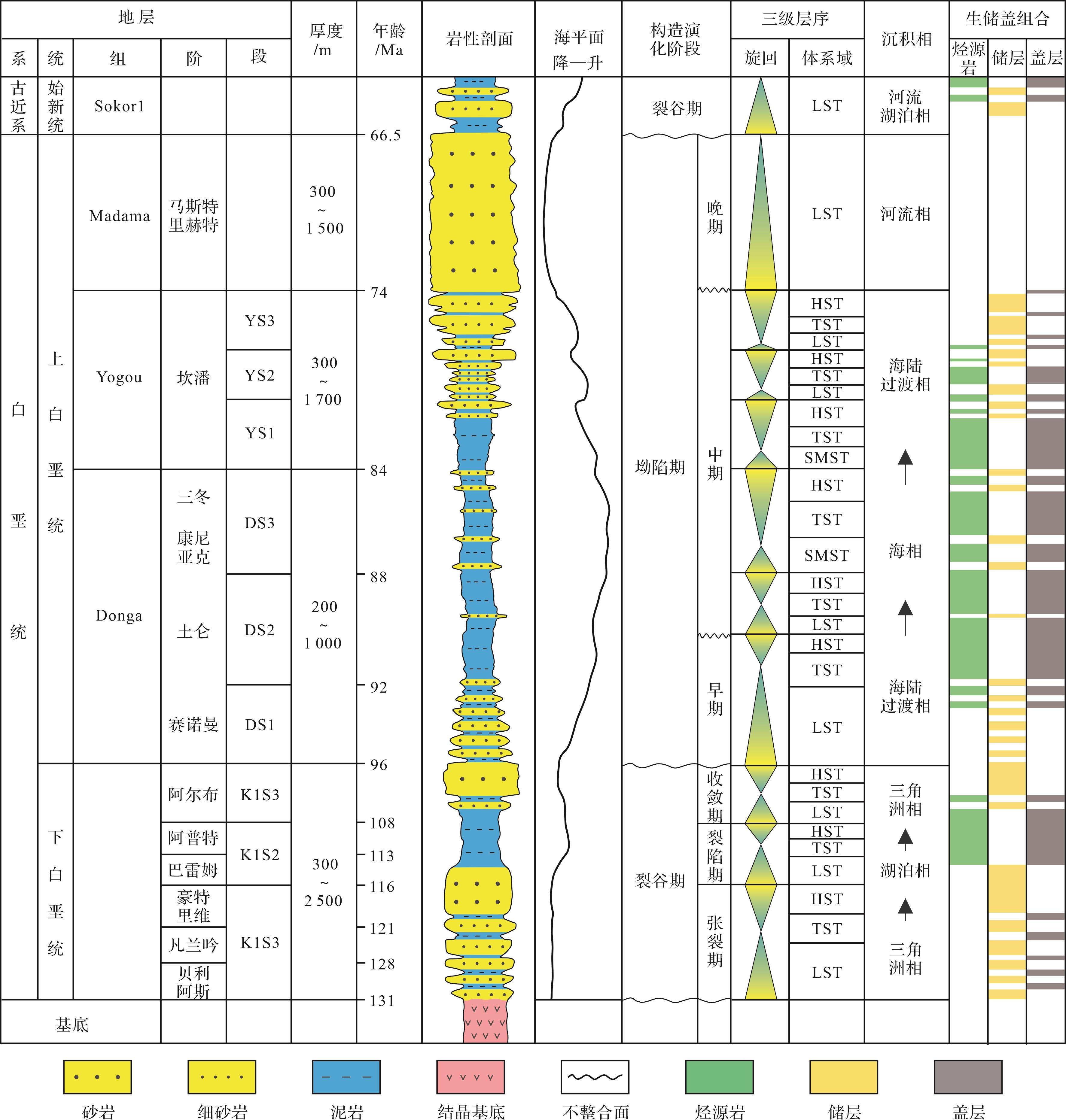
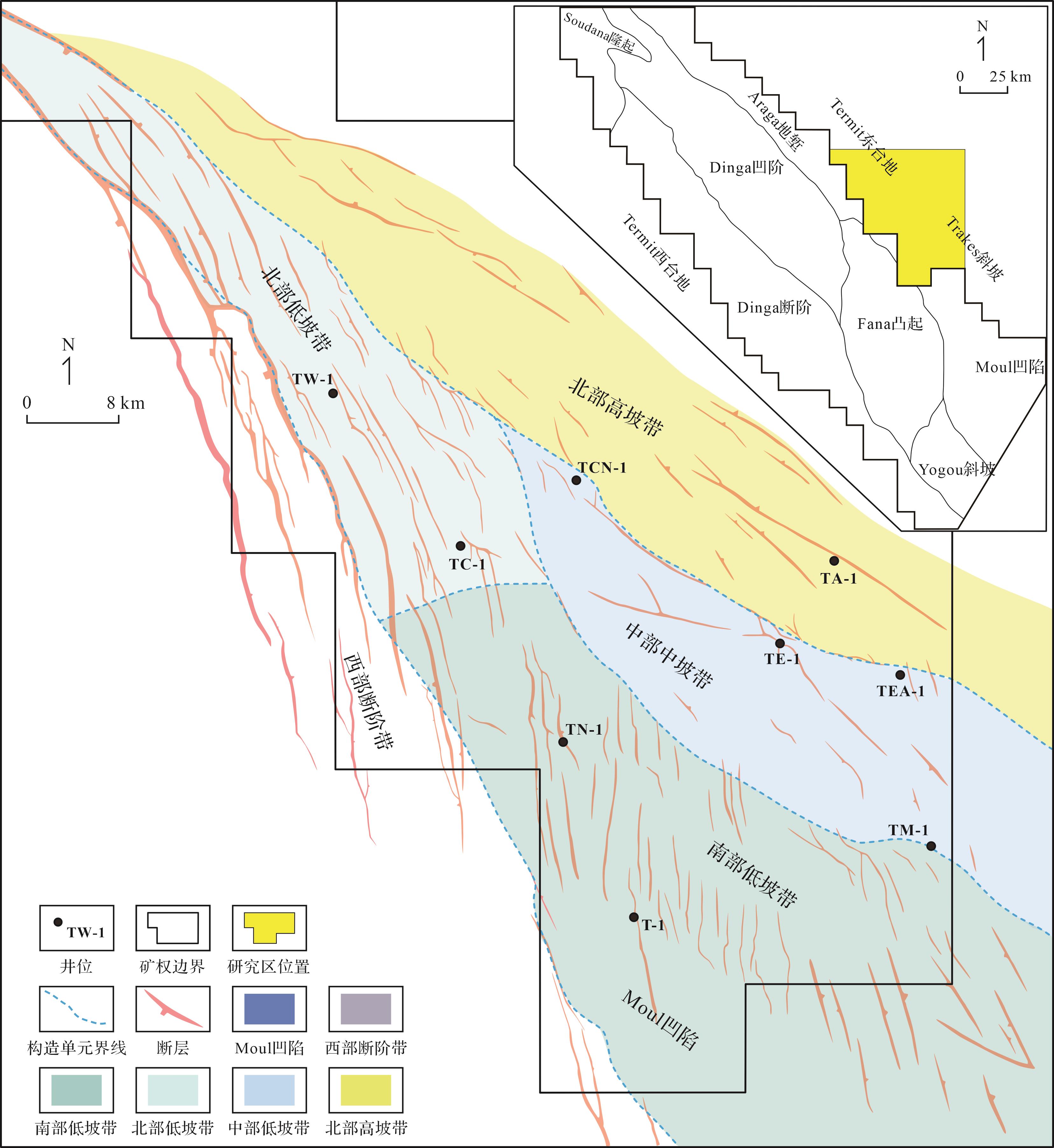
Termit盆地是西非裂谷系中典型的中—新生代裂谷盆地,位于非洲大陆内部,发育于前寒武系基底之上,是经历中生代—新生代两期裂谷叠合的含油气盆地(Browne and Fairhead,1983;Fairhead,1986;Binks and Fairhead,1992;Genik,1992,1993;刘邦等,2012a,2012b)。根据盆地构造特征,将Termit盆地划分出十个二级构造单元,分别为Termit西台地、Termit东台地、Soudana凸起、Dinga断阶、Dinga凹陷、Araga地堑、Yogou斜坡、Fana凸起、Moul凹陷和Trakes斜坡(图1)(吕明胜等,2015;王玉华等,2018)。地震及钻井资料揭示沉积地层有下白垩统(K1组)、上白垩统(Donga组、Yogou组、Madama组)、古近系(Sokor1组、Sokor2组)、新近系及第四系。Donga组沉积于晚白垩世赛诺曼期至圣通期,对应盆地演化的坳陷期,该时期盆地构造活动弱,以区域热沉降作用为主,同时发生大规模海侵,在非洲板块内部形成局限陆内海环境,并由下白垩统的陆相沉积转变为海陆过渡相—海相沉积(图2)(Philip et al.,1993;Guiraud et al.,2005;刘邦等,2011;Harouna and Philp,2012)。

图 1 Termit盆地Trakes斜坡区域位置、构造单元划分(据刘邦等,2012b修改)及取样井位图
Figure 1. Location and structural units of the Trakes slope in the Termit Basin with sampled wells(modified from Liu et al., 2012b)

图 2 Termit盆地白垩系综合柱状图(据Genik,1993修改)
Figure 2. Generalized stratigraphic column of the Cretaceous strata in the Termit Basin (modified from Genik, 1993)
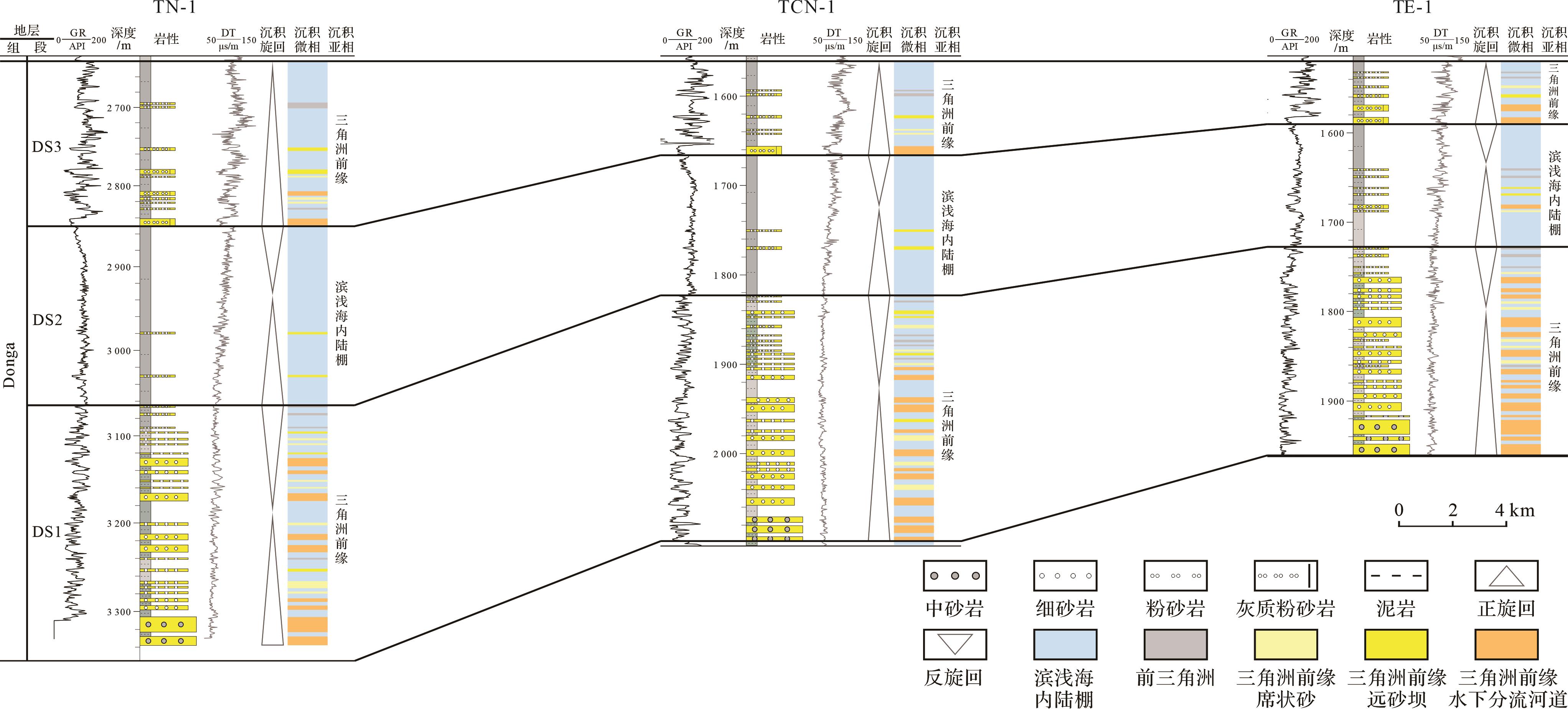
Trakes斜坡位于Termit盆地东南部,面积约4 000 km2,该斜坡发育一系列走滑断裂,主走滑断裂带走向主要为北北西—南南东和北西—南东向,次生雁列断层走向近南北。地震构造反演结果表明,Trakes斜坡总体表现为平缓单斜形态,北东高、南西低,根据构造差异,可进一步划分四个三级构造单元,分别为北部低坡带、南部低坡带、中部中坡带和东部高坡带(图1)。Donga组在垂向上表现出明显的分段性,地震和测井、录井特征差异明显,自下而上划分为DS1、DS2、DS3三段,总体自西向东厚度逐渐变薄(图2,3)。其中DS1段砂岩相对发育,地层平均沉积厚度330 m,测井特征表现为低自然伽马和低声波时差(GR<105 API,DT<75 μs/ft),地震剖面上具有连续性较好的中—强振幅反射特征;DS2段以厚层暗色泥页岩为主,地层平均厚度160 m,自然伽马和声波时差较高(GR介于105~130 API,DT介于75~95 μs/ft),地震特征表现为弱振幅反射;DS3段为暗色泥页岩发育,与薄层砂岩互层(图3),地层平均沉积厚度110 m,自然伽马和声波时差波动大(GR介于50~210 API,DT介于80~125 μs/ft),地震特征表现为强振幅连续反射。

图 3 Trakes斜坡上白垩统Donga组连井地层对比
Figure 3. Stratigraphic correlation of the Upper Cretaceous Donga Formation in the Trakes slope
-
选取Trakes斜坡4口井53个井壁取心及岩屑样品,进行普通薄片、铸体薄片、X射线衍射、扫描电镜等分析,结合测井、录井和地震资料,系统研究了Donga组储层砂体展布、岩石学特征、成岩作用及储层物性。
-
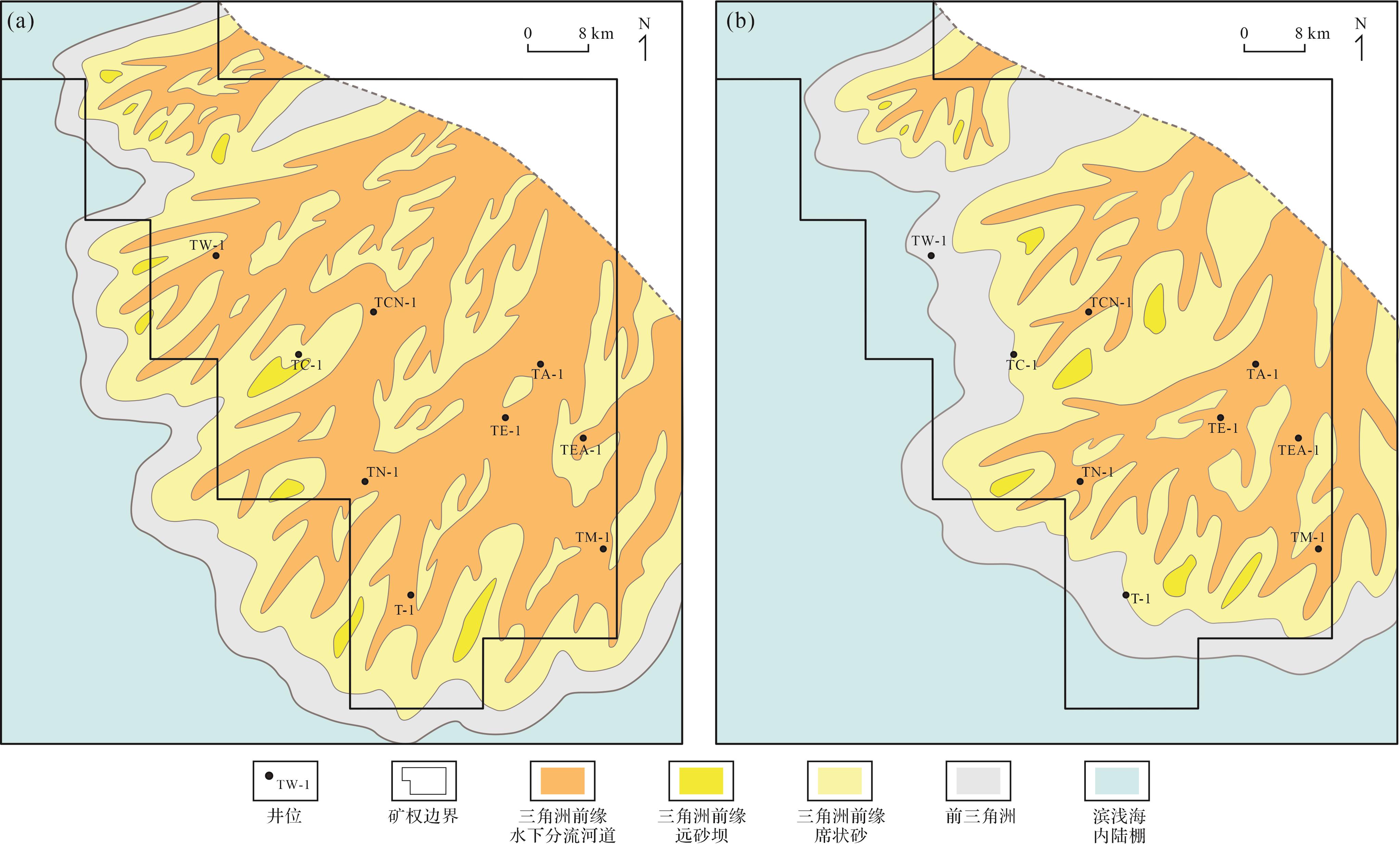
在晚白垩世塞诺曼期至圣通期,Trakes斜坡总体表现为平缓单斜(Fairhead,1986;Binks and Fairhead,1992;刘邦等,2012a,2012b;张庆莲等,2013;汤戈等,2015;毛凤军等,2016;王振升等,2016b;张光亚等,2022),北东高、南西低,紧邻东部物源区,由西向东地层厚度减薄。在层位解释基础上,利用三维地震资料开展地震相分析,结合测井、录井资料的单井相识别,编制了Donga组DS1~DS3段沉积相图(图4),并分析了砂体展布特征。总体上,Donga组砂体主要分布在DS1段和DS3段。DS1段主要为三角洲前缘水下分流河道沉积,广泛发育海相石英砂岩,展布面积广,自西向东砂地比增加,砂体在东部中高坡带最发育(图3,4)。DS2段以浅海陆棚相泥页岩沉积为主,夹少量薄层粉砂岩,砂体总体不发育,但在东部TM-1井DS2段发育三角洲前缘水下分流河道砂体,单层砂体厚度1~3 m(图3),测井孔隙度介于17%~21%,储层物性较好,单层试油测试自喷原油超过千桶,表明越靠近东部物源区时,砂岩油层越发育。DS3段主要为三角洲前缘席状砂沉积,深色泥页岩发育,砂体厚度薄、展布面积较小,储层以细粒岩屑石英砂岩为主,物性总体偏差。

图 4 Trakes斜坡上白垩统Donga组DS1段(a)和DS3段(b)沉积相图
Figure 4. Sedimentary facies of the DS1 (a) and DS3 (b) intervals of the Upper Cretaceous Donga Formation in the Trakes slope
-
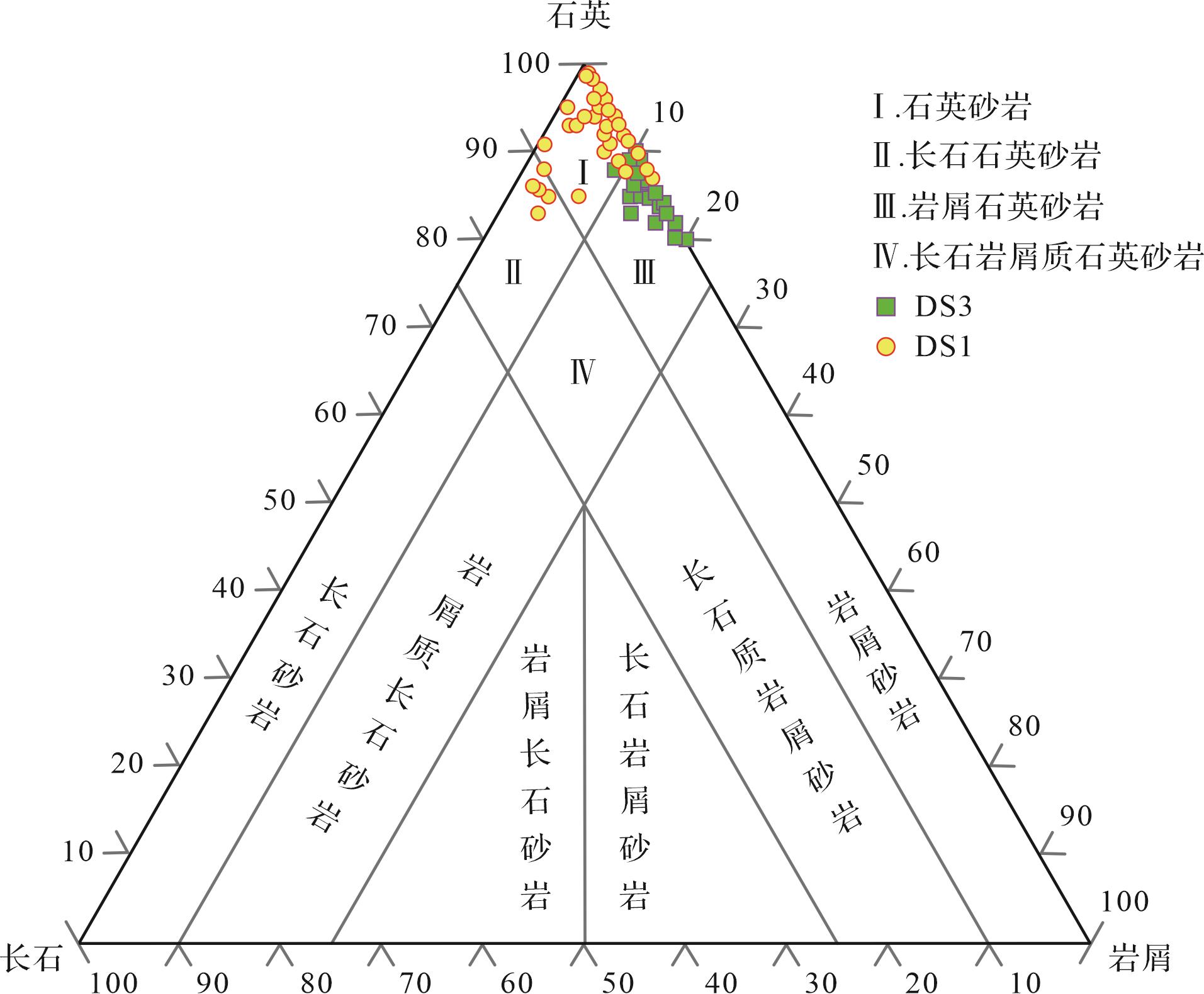
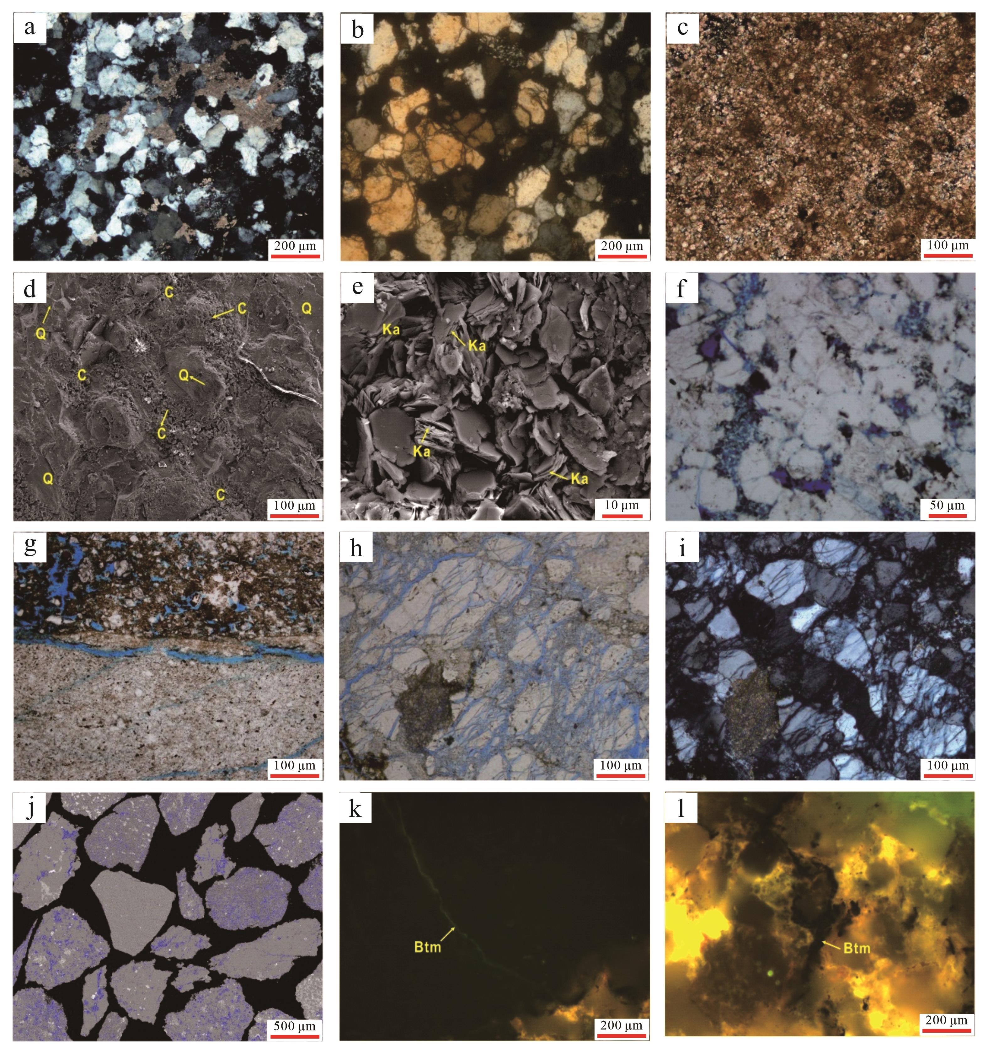
岩石薄片鉴定及全岩X射线衍射分析表明,DS1段储层岩石类型主要为细—中粒石英砂岩,DS3段主要为细粒岩屑石英砂岩(图5、图6a,b)。DS1段砂岩成分成熟度较高,以石英为主,其含量达到80%以上,岩石分选较差,石英粒度较粗,达到中粒级别;DS3段砂岩中石英含量76%~90%,平均值为83%,岩屑含量普遍大于10%,且主要为碳酸盐岩,碳酸盐岩含量介于1%~22%(平均值为8%),见细粉晶灰岩(图6c),DS3段储层岩石分选中等,细粒石英为主。总体上,Donga组砂岩以高岭土、方解石填隙物为主,灰质、黏土矿物和硅质胶结较为发育(图6a,d,e);储层岩石以细粒沉积为主,颗粒间主要为点—线接触,石英颗粒以次圆状—圆状为主,分选中等偏差。

图 5 Trakes斜坡上白垩统Donga组砂岩类型三角图
Figure 5. Compositional classification of the Upper Cretaceous Donga Formation in the Trakes slope

图 6 Trakes斜坡上白垩统Donga组储层岩石薄片、扫描电镜和背散射物性分析图
Figure 6. Thin section, scanning electron microscopy (SEM), and backscatter analysis of the Upper Cretaceous Donga Formation in the Trakes slope
-
Donga组储层岩石成岩作用总体上处于晚成岩A期(毛凤军等,2020),主要成岩作用有压实作用、胶结作用及溶蚀作用。Trakes斜坡Donga组埋深介于1 200~3 100 m,单层砂体厚度介于0.5~4.0 m,埋深大于2 500 m或单层砂岩厚度小于1.5 m时,储层压实作用明显,岩石薄片中多见石英颗粒间的点—线接触(图6a),点—线接触样品比例约为42%,厚层砂岩压实作用相对较弱,颗粒间点接触为主(图6b);对于填隙物含量较高的砂岩储层,由于孔隙间相对缺少刚性石英颗粒的有效支撑,压实作用较为强烈,储层岩石原生孔隙减少明显。胶结作用是导致储层孔隙度进一步减少的重要因素,随着地层压实作用增加,灰质、黏土矿物和硅质等胶结作用明显(图6b,d,e),研究区Donga组储层岩石硅质胶结强度不大,以Ⅰ~Ⅱ期石英次生加大为主(图6a,b),加大边宽度普遍小于10 μm且不连续,相对而言,灰质和黏土矿物胶结作用更为发育,其样品胶结物含量约占胶结物总量的55%,导致大量原生孔隙被充填。研究区溶蚀作用有助于形成次生孔隙,改善储层物性,薄片分析表明,Donga组储层岩石内普遍存在着碳酸盐岩、长石等矿物的溶蚀作用,形成粒内溶孔、粒间溶孔等次生孔隙(图6f,g)。此外,在Donga组储层岩石内常见微裂缝连通岩石孔隙喉道,并与溶蚀作用相结合,形成孔缝结合体(图6g,i),增强了储层的渗流性能。
-
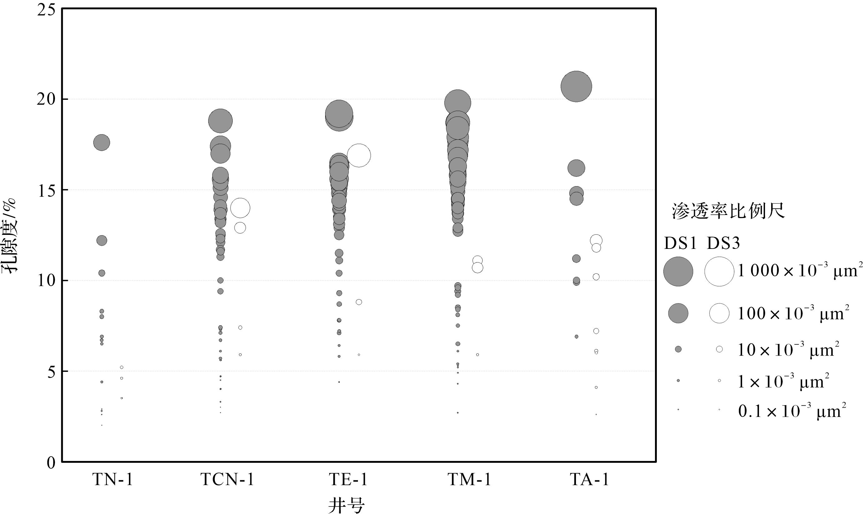
Donga组储层岩石孔隙类型以粒间次生孔隙为主,见不等量原生孔隙,储层孔隙度普遍小于25%、渗透率小于500×10-3 μm2。除部分东部地区DS1段储层为中孔中渗级别外(孔隙度介于15%~25%、渗透率介于(50~500)×10-3 μm2),大部分DS1段储层为低孔低渗级别(孔隙度小于15%、渗透率小于50×10-3 μm2),储层平均孔隙度为12.7%、平均渗透率为42.1×10⁻³ μm2;DS3段储层物性总体较差,除个别储层外,主要为低孔低渗—特低孔特低渗级别,储层平均孔隙度为8.3%、平均渗透率为19.5×10⁻³ μm2。总体上,DS1段储层孔隙度和渗透率高于DS3段,DS1段是Donga组优质储层的主要发育层段(图7),不同构造位置的探井储层孔隙度和渗透率对比表明,从位于西部的TN-1井,到位于中部的TCN-1、TE-1井,再到位于东部的TM-1井和TA-1井,DS1段储层物性依次变好(图7),平面上表现出从西向东储层物性变好的趋势。

图 7 Trakes斜坡上白垩统Donga组DS1和DS3段储层测井孔隙度—渗透率交会图
Figure 7. Cross plot of wireline logging porosity and permeability from the Upper Cretaceous Donga Formation in the Trakes slope
-
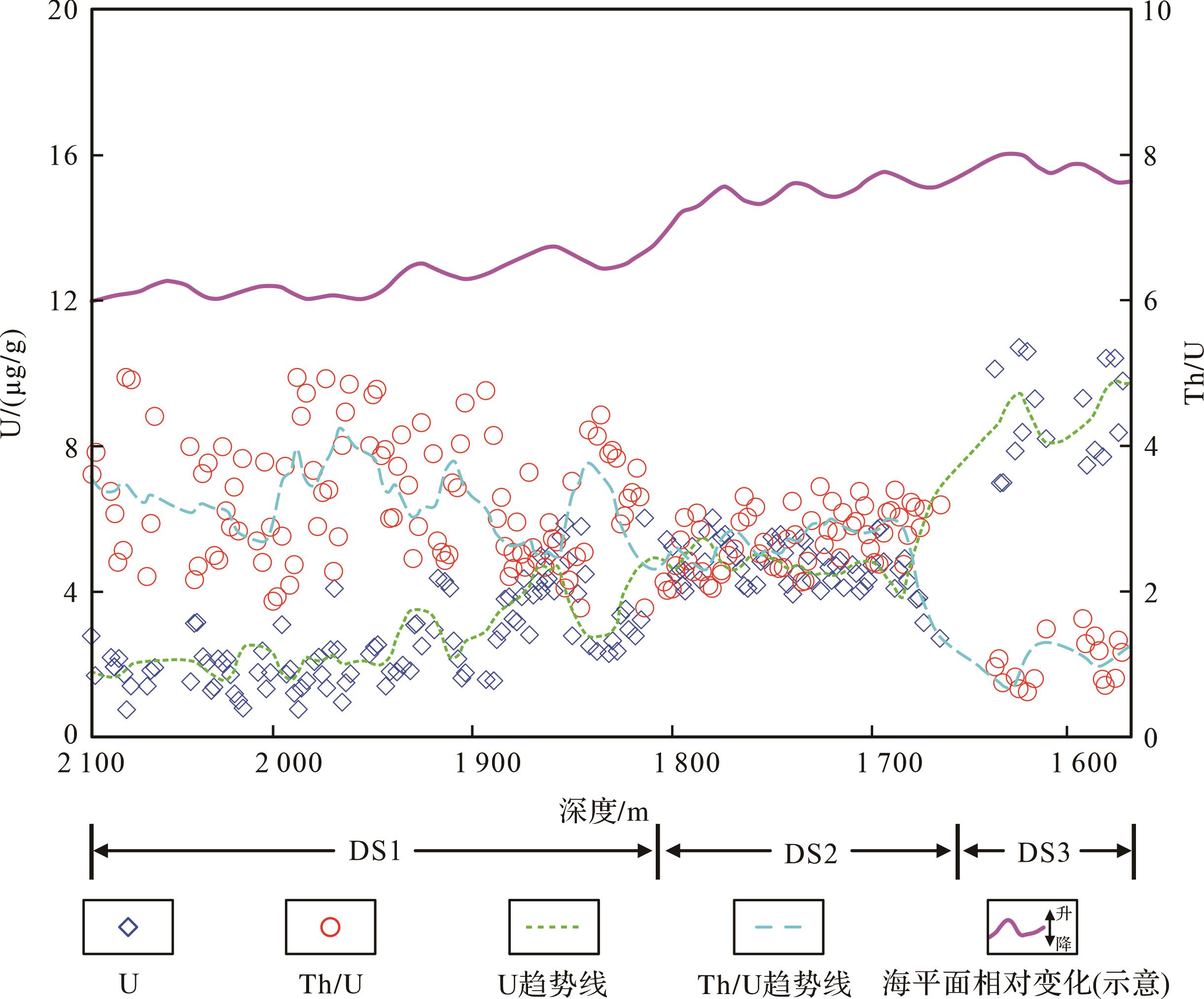
自然伽马能谱测井不仅可以反映总的伽马放射性强度,还可以定量测试元素铀(U)、钍(Th)、钾(K)含量,是恢复沉积盆地古环境、古气候的有效技术手段(刘泽纯等, 2000; Ehrenberg and Svånå,2001;陈中红等,2004;王学军等, 2008)。铀的化学性质比较活泼,岩石中铀富集机理主要是有机物质在成岩过程中对铀的还原和吸附作用,因此铀富集地层往往表征还原环境,相对而言,钍元素较铀元素化学性质稳定,在地层中含量变化较为稳定。由此,铀含量和Th/U比值可以用来指示古环境的氧化/还原程度,氧化环境中,岩石中铀元素含量减少,Th/U比值增大;还原环境中,铀元素含量增加,Th/U比值减少(Ehrenberg and Svånå,2001;陈中红等,2004)。
晚白垩世早期,全球海平面整体上升,Termit盆地发生大规模海侵,形成板块内部的局限陆内海环境,该时期盆地处于坳陷期,沉积环境由陆相逐渐过渡到海陆过渡相(图2)。DS1至DS3段铀含量和Th/U比值垂向上表现出明显的分段性(图8),具体表现为DS1段铀含量低、Th/U比值高;DS2段铀含量升高,Th/U比值降低;DS3段铀含量最高,Th/U比值最低。从下部DS1段到上部DS3段,铀含量增加,Th/U比值降低;录井岩屑特征上,泥页岩从DS1到DS3段颜色逐渐变深,由浅灰色泥岩变为深黑色页岩,DS3段页岩中普遍见黑色薄片状页理。以上特征均表明Donga组由DS1至DS3段古环境还原程度增加,海平面升高,其中DS1段低铀含量和高Th/U比值,表明其沉积环境偏氧化,古水深较小,对应海侵初始期;DS3段具有高铀含量和低Th/U比值,表明古水深和还原性达到最大,对应最大海泛面。

图 8 TCN⁃1井Donga组铀含量(U)和Th/U比值随深度散点分布图
Figure 8. Scatter diagram of uranium content and Th/U with depth for the Donga Formation from well TCN⁃1
晚白垩世局限陆内海平面变化控制Donga组沉积相及储层砂体垂向发育。DS1段沉积于塞诺曼期,对应海侵初始期,海平面较低,Trakes斜坡总体为海陆过渡相沉积环境,由于靠近东部物源区,物源供给充足,沉积物堆积速率大,形成低位体系域沉积,以三角洲前缘沉积为主,水下分流河道砂体发育,砂体垂向叠置,分布范围广(图3,4)。测井、录井资料揭示DS1段砂地比平均为46%,砂体平均累计厚度达150 m,东部近物源方向,DS1段砂体厚度逐渐增加,岩石中石英含量及石英粒度相对增大,储层物性逐渐变好(图7)。DS2段沉积于土伦期,海平面快速上升,海水范围进一步扩大,物源供给不足,以滨浅海内陆棚沉积为主,砂体不发育。DS3段沉积于康尼亚克期—圣通期,海平面达到最高,对应最大海泛期,水体咸度较大,有利于碳酸盐胶结物形成,该时期海平面波动较大,同时盆地东缘地层发生挤压抬升(Genik,1992,1993),使东部物源向Trakes斜坡方向推进,相较于DS1段,该时期三角洲前缘分流河道砂岩减少,三角洲前缘席状砂岩增加(图3,4),储层岩石主要为细粒岩屑石英砂岩,碳酸盐胶结物含量较高,地层中泥页岩发育,储层砂体以薄层透镜状粉砂岩、灰质粉砂岩为主,储层物性较差。
-
晚白垩世,非洲—阿拉伯板块内部裂陷活动较弱,Termit盆地进入坳陷期,以稳定热沉降为主。Trakes斜坡古地貌总体为平缓斜坡,坡度较小,表现为北东高、西南低的单斜构造(Faure,1966;刘邦等,2012b)。在稳定平缓古地貌背景下,Donga组砂体平面上分布范围广且连续性较好(图4),这保证了储层平面上良好的连通性,为该地区油气广泛分布创造了条件。此外,相比于其他二级构造单元,Trakes斜坡Donga组埋深相对较小,尤其是东部地区的DS1段埋深普遍小于2 500 m,储层岩石压实与胶结作用相对较弱,有利于储层原生孔隙的保存。
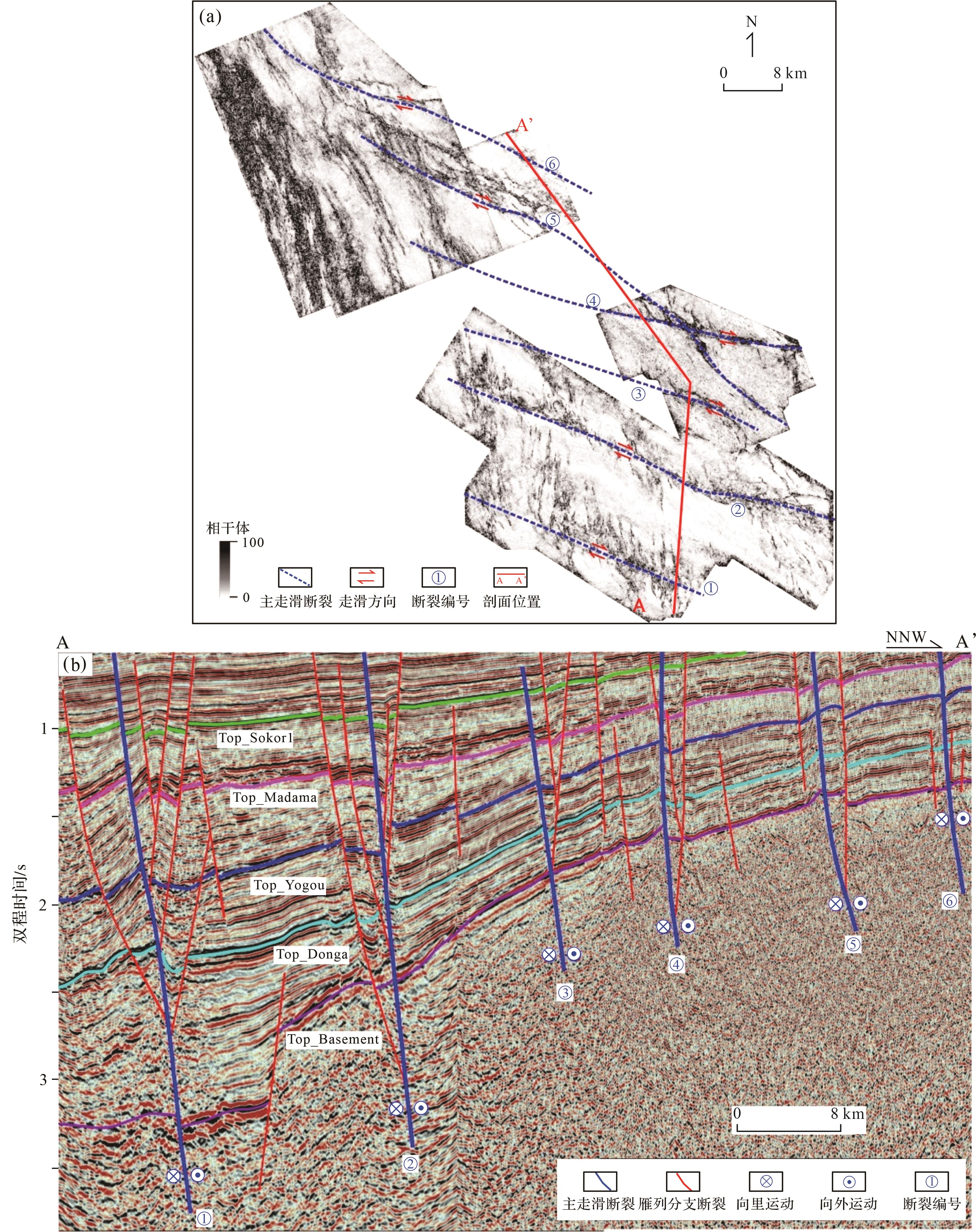
古近纪,Termit盆地发生强烈伸展裂陷活动,在研究区形成广泛分布的张扭性走滑断层,其中主走滑断裂带走向为北北西—南南东和北西—南东向,近直立状;次生雁列断层走向近南北向(图9a),剖面样式表现为负花状构造和Y型断裂。主干断裂带位移明显,多数断至花岗岩基底,且这些主干断裂长期活动,在主干断裂带两侧,发育一系列雁列式分支断裂(图9b),在主干和分支断裂附近Donga组破碎较严重,地震上呈现反射杂乱特征,储层岩心及薄片样品内见到大量的微裂缝(图6g~j),这些广泛发育的微裂缝连通岩石孔隙喉道,有效改善了储层岩石孔隙结构,提升了DS1、DS3段储层储集物性。同时,在DS1段部分储层岩石薄片中,发现大量沥青充填的微裂缝,表明这些由构造诱导形成的微裂缝可作为油气有效储集空间(图6k)。研究区钻井与地震资料分析表明,Donga组储层裂缝发育程度与走滑断裂位移和距离远近紧密相关。总体上,走滑强度越大、距离走滑断裂越近,裂缝越发育;走滑强度越小,距离走滑断裂越远,裂缝越不发育,岩石孔隙连通性差,储层物性特征不佳,难见油气发现,而处于负花状构造和Y型断裂带储层油气富集程度高,测试多见工业油流。

图 9 Trakes斜坡Sokor1组顶相干切片图(a)和走滑断裂地震剖面图(b)
Figure 9. Coherent body slice (a) and seismic section (b) of strike⁃slip faults in Trakes slope
-
压实与胶结作用是导致Donga组储层原生孔隙减少、物性变差的重要因素,特别是DS3段储层岩石中填隙物含量高,储层有效孔隙度低,物性差。促使Donga组储层岩石保孔增渗的成岩作用主要表现为两个方面:一是石英砂岩中较高的石英含量利于保存一部分原生孔隙,且在强烈张扭应力作用下,石英砂岩更容易破碎,有利于微裂缝发育(图6g~j);二是含不稳定矿物较多的砂岩储层中,溶蚀作用较发育,碳酸盐岩、长石等矿物易于发生溶蚀,形成大量次生孔隙(图6f,g),同时微裂缝连通岩石孔隙喉道,并与溶蚀作用相结合,形成孔缝结合体,进一步提升了储层物性。DS1段岩石薄片中见沥青充填微裂缝和粒间孔隙(图6,l),储层发生了油气充注与聚集,可见上述孔缝结合体对油气富集的有效性。特别地,相较于DS3段,DS1段储层厚度大、石英矿物含量高,靠近主走滑断裂带储层砂岩中大量发育微裂缝,溶蚀作用普遍,储层物性明显好于DS3段。
-
Termit盆地Donga组整体为一个海进沉积旋回,根据垂向上岩性和油层分布特征,可将Donga组划分出DS1、DS2和DS3三套储盖组合,其中两套区域盖层分别为DS2段和DS3段之上的YS1段海相泥页岩(图2),特别是Donga组之上厚度大、范围稳定分布的YS1段泥页岩,使Donga组生成的油气很难突破这套区域性盖层向上运聚,利于Donga组内形成“自生自储”储盖组合。特别是DS1段,发育一定量的中孔中渗储层,且之上有厚层DS2海相泥页岩作为盖层,储盖条件较好,部分探井具有较好的油气显示特征,测试后也获得了工业油流,由此Donga组具有较好勘探潜力,可作为下步潜力勘探目的层。Trakes斜坡发育的区域性走滑断裂带利于Donga组油气成藏,其不仅形成一系列构造圈闭,同时诱导形成大量岩石微裂缝,这些微裂缝有效改善了海相砂岩储层物性。此外,研究区东部高斜坡虽然走滑断裂活动弱,但是更靠近物源区,三角洲前缘水下分流河道砂体更发育,且埋藏浅,利于原生孔隙保存,也是油气勘探的有利指向区。综上所述,研究区Donga组垂向上DS1段是有利勘探层系,平面上有利勘探区包括南部强走滑断裂带和东部中、高斜坡三角洲前缘水下分流河道发育区。
-
(1) Termit盆地Trakes斜坡上白垩统Donga组自下而上划分为DS1、DS2、DS3三段。其中,DS1段储层的岩石类型主要为细—中粒石英砂岩,成分成熟度较高,DS3段主要为细粒岩屑石英砂岩,岩屑成分主要为碳酸盐岩。石英颗粒以次圆状—圆状为主,分选中等偏差,填隙物以高岭土、方解石为主,颗粒主要为点—线接触。
(2) Donga组储层的主要成岩作用为压实作用、胶结作用及溶蚀作用,压实和胶结作用明显,且普遍存在碳酸盐岩、长石等矿物的溶蚀作用,形成粒内溶孔、粒间溶孔等次生孔隙。Donga组储层岩石发育微裂缝,与溶蚀孔隙相结合,形成孔缝结合体。储层岩石孔隙类型以粒间次生孔隙为主,储层孔隙度均小于25%、渗透率小于500×10-3 μm2,为中孔中渗—特低孔特低渗。DS1段以三角洲前缘水下分流河道沉积为主,DS3段主要为三角洲前缘席状砂沉积。垂向上优质储层主要分布于DS1段,平面上从西向东储层物性变好。
(3) Donga组储层发育主要受三个因素控制:①海平面变化控制沉积相及储层垂向发育。DS1段对应海侵初始期,物源供给充足,储层砂体厚度大、分布广,储层物性好;DS3段沉积期,海平面达到最高,对应最大海泛期,水体较咸,储层砂体厚度小,碳酸盐胶结物含量高,储层物性较差。②稳定的缓坡古地貌易于Donga组砂体横向展布,古近纪强烈走滑断裂活动诱导储层岩石形成微裂缝,有效提升储层物性。③石英颗粒刚性支撑利于原生孔隙保存,碳酸盐岩、长石等不稳定矿物的溶蚀作用改善储层岩石孔隙结构。
Reservoir Characteristics and Controlling Factors of Marine Sandstones of the Upper Cretaceous Donga Formation in the Trakes Slope, Termit Basin, Niger
-
摘要: 目的 2019年以来,中石油在尼日尔Termit盆地Trakes斜坡针对新层系上白垩统Donga组开展风险勘探,多口井获得高产工业油流,展示出良好的勘探潜力,但相比于古近系河流—三角洲相Sokor1组,对Donga组海相砂岩储层仍缺乏系统性研究。 方法 基于地震和测录井资料,针对4口井53个井壁取心和岩屑样品,开展普通薄片、铸体薄片、X射线衍射、扫描电镜、自然伽马能谱测井等分析,研究Donga组DS1~DS3各段储层特征,并探讨其发育控制因素。 结果 DS1段储层的岩石类型主要为细—中粒石英砂岩,成分成熟度较高,DS3段主要为细粒岩屑石英砂岩,岩屑成分主要为碳酸盐岩。Donga组储层石英颗粒以次圆状—圆状为主,分选中等偏差,填隙物以高岭土、方解石为主,颗粒间多为点—线接触。成岩作用主要为压实作用、胶结作用及溶蚀作用,其中压实与胶结作用明显,且普遍存在溶蚀作用,孔隙类型以粒间次生孔隙为主,为中孔中渗—特低孔特低渗。垂向上Donga组优质储层主要分布于DS1段,平面上从西向东储层物性变好。Donga组海相储层发育主要受三个因素控制:(1)海平面变化控制沉积相及储层垂向发育,DS1段沉积于海侵初始期,发育三角洲前缘水下分流河道沉积,DS3段沉积于最大海泛期,以三角洲前缘席状砂和水下分流河道沉积为主,水体较咸,碳酸盐胶结物含量高,储层物性差。(2)晚白垩世稳定缓坡古地貌背景利于砂体发育,古近纪强烈走滑断裂活动诱导储层岩石形成微裂缝,有效提升了储层物性。(3)石英砂岩刚性支撑利于原生孔隙保存,碳酸盐岩、长石等不稳定矿物的溶蚀作用改善储层岩石孔隙结构。 结论 区域海相泥页岩盖层的发育利于Donga组形成 “自生自储”储盖组合,相较于Trakes斜坡低坡带,中部中坡带及北部高坡带更靠近东部物源,Donga组砂岩更发育,储层物性更好,是下步开展勘探的有利区带。Abstract: Objective Since 2019, CNPC has conducted exploration on the Upper Cretaceous Donga strata in the Trakes slope of the Termit Basin, Niger. Several wells obtained industrial oil flows, demonstrating good exploration potential. Compared to the Paleogene fluvial-deltaic Sokor1 Formation, the detailed characteristics of the Upper Cretaceous marine sandstones of the Donga Formation have not yet been fully examined. Methods In the present study, based on seismic, wireline, and mud logging data, 53 side wall cores and cutting samples from four wells were analyzed with thin sections, casting thin sections, X-ray diffraction, scanning electron microscopy, gamma-ray spectral logging, etc. Therefore, this study investigated the marine sandstone reservoir characteristics of DS1 member and DS3 member in the Donga Formation and analyzed their controlling factors. Results The results show that the rock type of the DS1 member is mainly fine-medium grained quartz sandstone with high component maturity, whereas the DS3 member is dominated by fine grained lithic quartz sandstone with mass calcareous mineral cement. The reservoir rock quartz grain is sub-round to round with moderate to poor sorting in the Donga Formation, the rock matrix is mainly composed of kaolinite and calcite, and most of quartz grains have point to line contact. Reservoir rock diagenesis have strong compaction and cementation, with common dissolution, and the pores are primarily intergranular with medium to ultra-low porosity and permeability. The high quality reservoirs in the Donga Formation are mainly distributed in the DS1 member, and reservoir physical property improves from west to east in Trakes slope. The analysis results show that the development of marine quartz sandstone in the Donga Formation is controlled by three factors. Firstly, vertical distribution of the sedimentary face and marine quartz sandstone was controlled by sea level changes, which manifested widespread marine distributary channel sandstones in the DS1 member that deposited in the early stage of marine transgression, whereas the DS3 member, in the highest sea level of marine deposit with high salinity, formed high contents of carbonate cement and poor reservoir physical property. Secondly, the stable gentle slope geomorphology in the Late Cretaceous was favorable for the development of marine sand bodies, and the intense strike-slip fault activities in the Paleogene induced the formation of micro-fractures in reservoir rock, which effectively improved the reservoir physical properties. Thirdly, the rigid construction of marine quartz sandstone granules was favorable for the preservation of rock primary pores, and the dissolution of unstable minerals such as feldspar and calcareous minerals improved the pore structure of the reservoir rock. Conclusions The development of a regional cap rock of marine mudstone and shale was conducive to the formation of self-generation and self-preservation reservoir in the Donga Formation. Compared with the lower slope zone of the Trakes slope, marine quartz sandstone has better reservoir physical properties and widespread distribution in the middle and high slope zones closer to the eastern sediment source area and are favorable for further exploration in the Donga Formation.
-
图 1 Termit盆地Trakes斜坡区域位置、构造单元划分(据刘邦等,2012b修改)及取样井位图
Figure 1. Location and structural units of the Trakes slope in the Termit Basin with sampled wells(modified from Liu et al., 2012b)
图 2 Termit盆地白垩系综合柱状图(据Genik,1993修改)
Figure 2. Generalized stratigraphic column of the Cretaceous strata in the Termit Basin (modified from Genik, 1993)
图 3 Trakes斜坡上白垩统Donga组连井地层对比
Figure 3. Stratigraphic correlation of the Upper Cretaceous Donga Formation in the Trakes slope
图 4 Trakes斜坡上白垩统Donga组DS1段(a)和DS3段(b)沉积相图
Figure 4. Sedimentary facies of the DS1 (a) and DS3 (b) intervals of the Upper Cretaceous Donga Formation in the Trakes slope
图 5 Trakes斜坡上白垩统Donga组砂岩类型三角图
Figure 5. Compositional classification of the Upper Cretaceous Donga Formation in the Trakes slope
图 6 Trakes斜坡上白垩统Donga组储层岩石薄片、扫描电镜和背散射物性分析图
Figure 6. Thin section, scanning electron microscopy (SEM), and backscatter analysis of the Upper Cretaceous Donga Formation in the Trakes slope
图 7 Trakes斜坡上白垩统Donga组DS1和DS3段储层测井孔隙度—渗透率交会图
Figure 7. Cross plot of wireline logging porosity and permeability from the Upper Cretaceous Donga Formation in the Trakes slope
图 8 TCN⁃1井Donga组铀含量(U)和Th/U比值随深度散点分布图
Figure 8. Scatter diagram of uranium content and Th/U with depth for the Donga Formation from well TCN⁃1
-
[1] 陈中红,查明,金强. 2004. 自然伽玛及自然伽玛能谱测井在沉积盆地古环境反演中的应用[J]. 地球物理学报,47(6):1145-1150. Chen Zhonghong, Zha Ming, Jin Qiang. 2004. Application of natural gamma ray logging and natural gamma spectrometry logging to recovering paleoenvironment of sedimentary basin[J]. Chinese Journal of Geophysics, 47(6): 1145-1150. [2] 程顶胜,窦立荣,张光亚,等. 2020. 中西非裂谷盆地白垩系两类优质烃源岩发育模式[J]. 地质学报,94(11):3449-3460. Cheng Dingsheng, Dou Lirong, Zhang Guangya, et al. 2020. Development pattern of two types of exceptional Cretaceous source rocks in the rift systems in West and Central Africa[J]. Acta Geologica Sinica, 94(11): 3449-3460. [3] 赖洪飞,李美俊,刘计国,等. 2018. 强制海退体系域中烃源岩的类型与测井评价:以尼日尔Termit盆地为例[J]. 沉积学报,36(2):390-400. Lai Hongfei, Li Meijun, Liu Jiguo, et al. 2018. Source rock types and logging evaluation in forced regressive systems tract: Taking the Termit Basin (Niger) as an example[J]. Acta Sedimentologica Sinica, 36(2): 390-400. [4] 李美俊,赖洪飞,毛凤军,等. 2018. 层序地层格架下烃源岩地球化学研究:以尼日尔Termit盆地为例[J]. 地球科学,43(10):3603-3615. Li Meijun, Lai Hongfei, Mao Fengjun, et al. 2018. Geochemical assessment of source rock within a stratigraphic geochemical framework: Taking Termit Basin (Niger) as an example[J]. Earth Science, 43(10): 3603-3615. [5] 刘邦,潘校华,万仑坤,等. 2012a. 东尼日尔Termit盆地叠置裂谷的演化:来自构造和沉积充填的制约[J]. 现代地质,26(2):317-325. Liu Bang, Pan Xiaohua, Wan Lunkun, et al. 2012a. Polyphase rift evolution of the Termit Basin, eastern Niger: Constraints from structural and sedimentary records[J]. Geoscience, 26(2): 317-325. [6] 刘邦,潘校华,万仑坤,等. 2012b. 东尼日尔Termit盆地构造演化及古近系油气成藏主控因素[J]. 石油学报,33(3):394-403. Liu Bang, Pan Xiaohua, Wan Lunkun, et al. 2012b. Structural evolution and main controlling factors of the Paleogene hydrocarbon accumulation in Termit Basin, eastern Niger[J]. Acta Petrolei Sinica, 33(3): 394-403. [7] 刘邦,潘校华,万仑坤,等. 2011. 东尼日尔盆地海侵的微体古生物和地球化学证据[J]. 现代地质,25(5):995-1006. Liu Bang, Pan Xiaohua, Wan Lunkun, et al. 2011. Marine transgression of the eastern Niger Basin in the Late Cretaceous: Paleontological and geochemical evidences[J]. Geoscience, 25(5): 995-1006. [8] 刘计国,郑凤云,毛凤军,等. 2022. 尼日尔Termit盆地古近系Sokor1组储层特征及其主控因素[J]. 岩石学报,38(9):2581-2594. Liu Jiguo, Zheng Fengyun, Mao Fengjun, et al. 2022. Reservoir characteristics and its controlling factors of the Paleogene Sokor1 Formation in Termit Basin, Niger[J]. Acta Petrologica Sinica, 38(9): 2581-2594. [9] 刘若涵. 2017. 尼日尔Termit盆地上白垩统沉积体系研究[D]. 北京:中国地质大学(北京):94-97. Liu Ruohan. 2017. The sedimentary system of Upper Cretaceous in Termit Basin, Niger[D]. Beijing: China University of Geosciences (Beijing): 94-97. [10] 刘泽纯,陈晔,袁林旺,等. 2000. 应用自然伽玛测井曲线反演2.85 Ma B.P.来古气候变化[J]. 中国科学:地球科学,30(6):609-618. Liu Zechun, Chen Ye, Yuan Linwang, et al. 2000. The application of natural gamma logging curve to recovering palaeo-climatic changes from 2.85 Ma B.P.[J]. Science China Earth Sciences, 30(6): 609-618. [11] 吕明胜,薛良清,万仑坤,等. 2015. 西非裂谷系Termit盆地古近系油气成藏主控因素分析[J]. 地学前缘,22(6):207-216. Mingsheng Lü, Xue Liangqing, Wan Lunkun, et al. 2015. Main controlling factors of Paleogene hydrocarbon accumulation of Termit Basin, West African rift system[J]. Earth Science Frontiers, 22(6): 207-216. [12] 毛凤军,刘邦,刘计国,等. 2019. 尼日尔Termit盆地上白垩统储层岩石学特征及控制因素分析[J]. 岩石学报,35(4):1257-1268. Mao Fengjun, Liu Bang, Liu Jiguo, et al. 2019. The reservoir characteristics and controlling factors of the Upper Cretaceous sandstones in the Termit Basin, Niger[J]. Acta Petrologica Sinica, 35(4): 1257-1268. [13] 毛凤军,刘计国,姜虹,等. 2020. 西非裂谷系Termit盆地白垩系砂岩成岩作用及有利储层发育区预测[J]. 中国石油勘探,25(4):86-94. Mao Fengjun, Liu Jiguo, Jiang Hong, et al. 2020. Diagenesis of Cretaceous sandstone and prediction of favorable reservoir development area in the Termit Basin of the West African rift system[J]. China Petroleum Exploration, 25(4): 86-94. [14] 毛凤军,刘若涵,刘邦,等. 2016. 尼日尔Termit盆地及其周缘晚白垩世古地理演化[J]. 地学前缘,23(3):186-197. Mao Fengjun, Liu Ruohan, Liu Bang, et al. 2016. Palaeogeographic evolution of the Upper Cretaceous in Termit Basin and its adjacent areas, Niger[J]. Earth Science Frontiers, 23(3): 186-197. [15] 汤戈,孙志华,苏俊青,等. 2015. 西非Termit盆地白垩系层序地层与沉积体系研究[J]. 中国石油勘探,20(4):81-88. Tang Ge, Sun Zhihua, Su Junqing, et al. 2015. Study of Cretaceous sequential stratigraphy and sedimentary system in Termit Basin of West Africa[J]. China Petroleum Exploration, 20(4): 81-88. [16] 汤望新,姜在兴,刘若涵,等. 2017. 尼日尔Termit盆地Yogou组泥岩地球化学特征及沉积背景[J]. 石油与天然气地质,38(3):592-601,632. Tang Wangxin, Jiang Zaixing, Liu Ruohan, et al. 2017. Geochemical characteristics and deposition environment of the Yogou Formation mudstone in the Termit Basin, Niger[J]. Oil & Gas Geology, 38(3): 592-601, 632. [17] 王学军,王志欣,刘显阳,等. 2008. 利用铀的测井响应恢复鄂尔多斯盆地古水深[J]. 天然气工业,28(7):46-48. Wang Xuejun, Wang Zhixin, Liu Xianyang, et al. 2008. Restoring palaeo-depth of the Ordos Basin by using uranium response from GR logging[J]. Natural Gas Industry, 28(7): 46-48. [18] 王玉华,毛凤军,王芝尧,等. 2018. Termit盆地构造特征及其对成藏的控制作用[J]. 复杂油气藏,11(4):12-16. Wang Yuhua, Mao Fengjun, Wang Zhiyao, et al. 2018. Tectonic characteristics and control effect of hydrocarbon accumulation in Termit Basin[J]. Complex Hydrocarbon Reservoirs, 11(4): 12-16. [19] 王振升,汤戈,苏俊青,等. 2016a. 尼日尔Moul凹陷白垩系Yogou组海陆过渡相沉积与成藏条件[J]. 天然气地球科学,27(7):1153-1163. Wang Zhensheng, Tang Ge, Su Junqing, et al. 2016b. Marine-continental transitional sedimentation and hydrocarbon accumulation condition of Cretaceous Yogou Formation in Moul Sag, Niger[J]. Natural Gas Geoscience, 27(7): 1153-1163. [20] 王振升,汤戈,苏俊青,等. 2016b. 西非Termit盆地白垩纪层序充填样式的时空演化规律研究[J]. 地层学杂志,40(1):100-106. Wang Zhensheng, Tang Ge, Su Junqing, et al. 2016a. Spatial-temporal evolution of the Cretaceous sedimentary sequences and basin filling patterns in the Termit Basin of West Africa[J]. Journal of Stratigraphy, 40(1): 100-106. [21] 薛良清,万仑坤,毛凤军,等. 2012. 东尼日尔盆地Termit坳陷油气富集规律及Dibeilla-1井发现的意义[J]. 中国石油勘探,17(4):53-59. Xue Liangqing, Wan Lunkun, Mao Fengjun, et al. 2012. Petroleum migration and accumulation in Termit Depression of East Niger Basin and implications for discovery of well Dibeilla[J]. China Petroleum Exploration, 17(4): 53-59. [22] 袁圣强,毛凤军,郑凤云,等. 2018. 尼日尔Termit盆地上白垩统成藏条件分析与勘探策略[J]. 地学前缘,25(2):42-50. Yuan Shengqiang, Mao Fengjun, Zheng Fengyun, et al. 2018. Analysis of hydrocarbon accumulation condition and exploration tactics of the Upper Cretaceous strata in the Termit Basin, Niger[J]. Earth Science Frontiers, 25(2): 42-50. [23] 张光亚,黄彤飞,刘计国,等. 2022. 中西非叠合裂谷盆地形成与演化[J]. 岩石学报,38(9):2539-2553. Zhang Guangya, Huang Tongfei, Liu Jiguo, et al. 2022. Formation and evolution of West and Central African superimposed rift basins[J]. Acta Petrologica Sinica, 38(9): 2539-2553. [24] 张庆莲,侯贵廷,潘校华,等. 2013. Termit盆地构造变形的力学机制[J]. 大地构造与成矿学,37(3):377-383. Zhang Qinglian, Hou Guiting, Pan Xiaohua, et al. 2013. Mechanics of Termit Basin in central Africa rift systems[J]. Geotectonica et Metallogenia, 37(3): 377-383. [25] 周立宏,苏俊青,董晓伟,等. 2017. 尼日尔Termit裂谷型叠合盆地油气成藏特征与主控因素[J]. 石油勘探与开发,44(3):330-339. Zhou Lihong, Su Junqing, Dong Xiaowei, et al. 2017. Controlling factors of hydrocarbon accumulation in Termit rift super-imposed basin, Niger[J]. Petroleum Exploration and Development, 44(3): 330-339. [26] 周立宏,汤戈,苏俊青,等. 2018. 西非Termit叠合裂谷盆地构造沉积演化及控藏机理[J]. 石油学报,39(2):129-140. Zhou Lihong, Tang Ge, Su Junqing, et al. 2018. Tectonic-sedimentary evolution and reservoir controlling mechanism of Termit superimposed rift basin in West Africa[J]. Acta Petrolei Sinica, 39(2): 129-140. [27] Binks R M, Fairhead J D. 1992. A plate tectonic setting for Mesozoic rifts of West and Central Africa[J]. Tectonophysics, 213(1/2): 141-151. [28] Browne S E, Fairhead J D. 1983. Gravity study of the Central African rift system: A model of continental disruption 1. The Ngaoundere and Abu Gabra rifts[J]. Tectonophysics, 94(1/2/3/4): 187-203. [29] Burke K C. 1976. The Chad Basin: An active intra-continental basin[J]. Developments in Geotectonics, 12: 197-206. [30] Burke K C, Dessauvagie T F J, Whiteman A J. 1972. Geological history of the Benue valley and adjacent areas[M]//Dessauragie T J F, Whiteman A J. African geology. Ibadan, Nigeria: Ibadan University Press: 187-205. [31] Dou L R, Bai G S, Liu B, et al. 2022. Sedimentary environment of the Upper Cretaceous Yogou Formation in Termit Basin and its significance for high-quality source rocks and Trans-Saharan Seaway[J]. Marine and Petroleum Geology, 142: 105732. [32] Ehrenberg S N, Svånå T A. 2001. Use of spectral gamma-ray signature to interpret stratigraphic surfaces in carbonate strata: An example from the Finnmark carbonate platform (Carboniferous-Permian), Barents Sea[J]. AAPG Bulletin, 85(2): 295-308. [33] Fairhead J D. 1986. Geophysical controls on sedimentation within the African rift systems[J]. Geological Society, London, Special Publications, 25(1): 19-27. [34] Faure H. 1966. Reconnaissance géologique des formations sédimentaires post-paléozoiques du Niger oriental[M]. Paris: BRGM. [35] Genik G J. 1992. Regional framework, structural and petroleum aspects of rift basins in Niger, Chad and the Central African Republic (C.A.R.)[J]. Tectonophysics, 213(1/2): 169-185. [36] Genik G J. 1993. Petroleum geology of Cretaceous-Tertiary rift basins in Niger, chad, and central African republic[J]. AAPG Bulletin, 77(8): 1405-1434. [37] Guiraud R, Bosworth W, Thierry J, et al. 2005. Phanerozoic geological evolution of northern and Central Africa: An overview[J]. Journal of African Earth Sciences, 43(1/2/3): 83-143. [38] Harouna M, Philp R P. 2012. Potential petroleum source rocks in the Termit Basin, Niger[J]. Journal of Petroleum Geology, 35(2): 165-185. [39] Lai H F, Li M J, Liu J G, et al. 2018. Organic geochemical characteristics and depositional models of Upper Cretaceous marine source rocks in the Termit Basin, Niger[J]. Palaeogeography, Palaeoclimatology, Palaeoecology, 495: 292-308. [40] Liu B, Wan L K, Mao F J, et al. 2015. Hydrocarbon potential of Upper Cretaceous marine source rocks in the Termit Basin, Niger[J]. Journal of Petroleum Geology, 38(2): 157-175. [41] Liu B, Zhang G Y, Mao F J, et al. 2017. Geochemistry and origin of Upper Cretaceous oils from the Termit Basin, Niger[J]. Journal of Petroleum Geology, 40(2): 195-207. [42] Maurin J C, Guiraud R. 1993. Basement control in the development of the Early Cretaceous West and Central African rift system[J]. Tectonophysics, 228(1/2): 81-95. [43] Olade M A. 1975. Evolution of Nigeria’s Benue trough (Aulacogen): A tectonic model[J]. Geological Magazine, 112(6): 575-583. [44] Petters S W. 1978. Stratigraphic evolution of the Benue trough and its implications for the Upper Cretaceous paleogeography of West Africa[J]. The Journal of Geology, 86(3): 311-322. [45] Petters S W. 1979. Paralic arenaceous foraminifera from the Upper Cretaceous of the Benue Trough, Nigeria[J]. Acta Palaeontologica Polonica, 24(4): 451-471. [46] Philip J, Babinot J F, Tronchetti G, et al. 1993. Late Cenomanian ( 94-92 Ma)[M]//Dercourt J, Ricou L E, Vrielynck B. Atlas Tethys palaeoenvironmental maps. Explanatory notes. Paris: Gauthier-Villars: 153-178. [47] Wan L K, Liu J G, Mao F J, et al. 2014. The petroleum geochemistry of the Termit Basin, eastern Niger[J]. Marine and Petroleum Geology, 51: 167-183. [48] Wang X Y, Wan L K, Jiang Z X, et al. 2017. Controlling factors and accumulation model of hydrocarbon reservoirs in the Upper Cretaceous Yogou Formation, Koulele area, Termit Basin, Niger[J]. Journal of Earth Science, 28(6): 1126-1134. [49] Zanguina M, Bruneton A, Gonnard R. 1998. An introduction to the petroleum potential of Niger[J]. Journal of Petroleum Geology, 21(1): 83-103. -

 点击查看大图
计量
- 文章访问数: 587
- HTML全文浏览量: 63
- PDF下载量: 30
- 被引次数: 0