Advanced Search
Volume 42 Issue 5
Oct.  2024
Turn off MathJax
Article Contents

CAO Jun, QIAO XiangYang, HE YongHong, ZHOU JinSong, DU YongHui, WANG XiTong, TIAN Kun, ZHAO ZiDan, ZHU GengBoLun, LUO ShunShe. Simulation Experiment of Shallow Meandering River Delta Sedimentation in the 2nd Member of the Shanxi Formation in Yan'an, Ordos Basin[J]. Acta Sedimentologica Sinica, 2024, 42(5): 1685-1698. doi: 10.14027/j.issn.1000-0550.2022.121
Citation: CAO Jun, QIAO XiangYang, HE YongHong, ZHOU JinSong, DU YongHui, WANG XiTong, TIAN Kun, ZHAO ZiDan, ZHU GengBoLun, LUO ShunShe. Simulation Experiment of Shallow Meandering River Delta Sedimentation in the 2nd Member of the Shanxi Formation in Yan'an, Ordos Basin[J]. Acta Sedimentologica Sinica, 2024, 42(5): 1685-1698. doi: 10.14027/j.issn.1000-0550.2022.121

Simulation Experiment of Shallow Meandering River Delta Sedimentation in the 2nd Member of the Shanxi Formation in Yan'an, Ordos Basin

doi: 10.14027/j.issn.1000-0550.2022.121
Funds:

Science and Technology Project of Shaanxi Yanchang Petroleum (Group) Co., Ltd ycsy2019ky-A-19

  • Received Date: 2022-05-18
  • Accepted Date: 2022-11-30
  • Rev Recd Date: 2022-09-26
  • Available Online: 2022-11-30
  • Publish Date: 2024-10-10
  • Objective Exploration has shown that the sand body of the Shanxi Formation, the main gas producing layer in the Yan 'an gas field in the southeastern Ordos Basin, is distributed in a long and narrow strip, which is significantly different from its distribution in the north. It is of great significance to clarify the genesis mechanism of the sand body in the 2nd member of Shanxi Formation for understanding the distribution pattern of sand bodies in the area. Methods Taking the 2nd member of the Shanxi Formation in the southeastern basin as the geological prototype, a flume sedimentation simulation experiment was used to investigate the sand formation, evolution process, and control factors. [Results and Conclusions] The gentle slope and low flow intensity of the 2nd member of the Shanxi Formation distributary channel is an important factor in the low sinuosity of the meandering flow state, and the horizontal amplitude rate is a key feature in the longitudinal extension of the sand body, sand size, aspect ratio of the coast, and change of flow control. The extension of the entire distance and length-width ratio of the sand were proportional to the scale and rate of water withdrawal. During the sedimentary period of the Shanxi Formation, the water level dropped significantly, and the shoreline migrated a long distance to the lake area. The water inlet retreated frequently, and the sand in the front of the meandering river delta extended a long distance. The sand superposition style has the characteristics of "vertical superposition", "vertical cutting", and "lateral migration". The results are of great significance to the prediction of sand bodies in the Shanxi Formation and the search for high-quality reservoirs.
  • [1] 王香增. 延长探区天然气勘探重大突破及启示[J]. 石油与天然气地质,2014,35(1):1-9.

    Wang Xiangzeng. Major breakthrough of gas exploration in Yangchang blocks and its significance[J]. Oil & Gas Geology, 2014, 35(1): 1-9.
    [2] 王香增,周进松. 鄂尔多斯盆地东南部下二叠统山西组二段物源体系及沉积演化模式[J]. 天然气工业,2017,37(11):9-17.

    Wang Xiangzeng, Zhou Jinsong. Provenance system and sedimentary evolution model of the Second member of Lower Permian Shanxi Fm in the southeastern Ordos Basin[J]. Natural Gas Industry, 2017, 37(11): 9-17.
    [3] 于兴河,王香增,王念喜,等. 鄂尔多斯盆地东南部上古生界层序地层格架及含气砂体沉积演化特征[J]. 古地理学报,2017,19(6):935-954.

    Yu Xinghe, Wang Xiangzeng, Wang Nianxi, et al. Sequence stratigraphic framework and sedimentary evolution characteristics of gas-bearing sandbody in the Upper Paleozoic in southeastern Ordos Basin[J]. Journal of Palaeogeography, 2017, 19(6): 935-954.
    [4] 赵晨帆,于兴河,付超,等. 曲流河三角洲—辫状河三角洲控制因素及演化过程探讨[J]. 沉积学报,2019,37(4):768-784.

    Zhao Chenfan, Yu Xinghe, Fu Chao, et al. Control factors and evolution progress of depositional system transition from meandering river delta to braided river delta: Case study of Shan2 member to He8 member, Ordos Basin[J]. Acta Sedimentologica Sinica, 2019, 37(4): 768-784.
    [5] 韩永林,王成玉,王海红,等. 姬塬地区长8油层组浅水三角洲沉积特征[J]. 沉积学报,2009,27(6):1057-1064.

    Han Yonglin, Wang Chengyu, Wang Haihong, et al. Sedimentary characteristics of shallow-water deltas in Chang-8 subsection of Yanchang Formation, Jiyuan area[J]. Acta Sedimentologica Sinica, 2009, 27(6): 1057-1064.
    [6] 李亚龙,于兴河,周进松,等. 鄂尔多斯盆地东南部山2段物源与曲流河三角洲沉积体系[J]. 沉积学报,2017,35(3):540-551.

    Li Yalong, Yu Xinghe, Zhou Jinsong, et al. The study on pro-venance and meandering river delta system of Shan 2 member in southeastern Ordos Basin[J]. Acta Sedimentologica Sinica, 2017, 35(3): 540-551.
    [7] 郭英海,刘焕杰,权彪,等. 鄂尔多斯地区晚古生代沉积体系及古地理演化[J]. 沉积学报,1998,16(3):44-51.

    Guo Yinghai, Liu Huanjie, Quan Biao, et al. Late Paleozoic sedimentary system and paleogeographic evolution of Ordos area[J]. Acta Sedimentologica Sinica, 1998, 16(3): 44-51.
    [8] 付锁堂,田景春,陈洪德,等. 鄂尔多斯盆地晚古生代三角洲沉积体系平面展布特征[J]. 成都理工大学学报(自然科学版),2003,30(3):236-241.

    Fu Suotang, Tian Jingchun, Chen Hongde, et al. The delta depositional system distribution of Late Paleozoic Era in Ordos Basin[J]. Journal of Chengdu University of Technology (Science & Technology Edition), 2003, 30(3): 236-241.
    [9] 郝爱武,蒲仁海,郭向东. 鄂尔多斯盆地中部山西组三角洲—曲流河沉积[J]. 西北大学学报(自然科学版),2011,41(3):480-484.

    Hao Aiwu, Pu Renhai, Guo Xiangdong. Evidences of fluvial deposition of Shanxi Formation in central Ordos Basin[J]. Journal of Northwest University (Natural Science Edition), 2011, 41(3): 480-484.
    [10] 朱红涛,陈开远, Liu Keyu,等. 鄂尔多斯盆地东北部山西组河流相沉积证据[J]. 天然气工业,2007,27(12):68-70.

    Zhu Hongtao, Chen Kaiyuan, Liu Keyu, et al. Evidences for deposits of fluvial facies in Shanxi Formation in northeastern Ordos Basin[J]. Natural Gas Industry, 2007, 27(12): 68-70.
    [11] 叶黎明,齐天俊,彭海燕. 鄂尔多斯盆地东部山西组海相沉积环境分析[J]. 沉积学报,2008,26(2):202-210.

    Ye Liming, Qi Tianjun, Peng Haiyan. Depositional environment analysis of Shanxi Formation in eastern Ordos Basin[J]. Acta Sedimentologica Sinica, 2008, 26(2): 202-210.
    [12] 周进松,王念喜,赵谦平,等. 鄂尔多斯盆地东南部延长探区上古生界天然气成藏特征[J]. 天然气工业,2014,34(2):34-41.

    Zhou Jinsong, Wang Nianxi, Zhao Qianping, et al. Natural gas accumulation characteristics in the Upper Paleozoic in the Yanchang exploration block of southeastern Ordos Basin[J]. Natural Gas Industry, 2014, 34(2): 34-41.
    [13] 付锁堂. 鄂尔多斯盆地北部上古生界沉积体系及砂体展布规律研究[D]. 成都:成都理工大学,2004.

    Fu Suotang. The study on the depositional system and sand body spreading regularity of Upper Paleozoic in north Ordos Basin[D]. Chengdu: Chengdu University of Technology, 2004.
    [14] 刘忠保,罗顺社,何幼斌,等. 缓坡浅水辫状河三角洲沉积模拟实验研究[J]. 水利与建筑工程学报,2011,9(6):9-14.

    Liu Zhongbao, Luo Shunshe, He Youbin, et al. Study on sedimentation simulation experiment of gentle-slope shallow braided river delta[J]. Journal of Water Resources and Architectural Engineering, 2011, 9(6): 9-14.
    [15] 朱永进,尹太举,沈安江,等. 鄂尔多斯盆地上古生界浅水砂体沉积模拟实验研究[J]. 天然气地球科学,2015,26(5):833-844.

    Zhu Yongjin, Yin Taiju, Shen Anjiang, et al. Experiments on shallow-lacustrine deltaic sandstone in the Ordos Basin (Upper Paleozoic), central China[J]. Natural Gas Geoscience, 2015, 26(5): 833-844.
    [16] 刘晓鹏,赵小会,康锐,等. 鄂尔多斯盆地北部盒8段砂体形成机理分析[J]. 岩性油气藏,2015,27(5):196-203.

    Liu Xiaopeng, Zhao Xiaohui, Kang Rui, et al. Formation mechanism of sand bodies of the Eighth member of Shihezi Formation in northern Ordos Basin[J]. Lithologic Reservoirs, 2015, 27(5): 196-203.
    [17] 王俊辉,姜在兴,张元福,等. 三角洲沉积的物理模拟[J]. 石油与天然气地质,2013,34(6):758-764.

    Wang Junhui, Jiang Zaixing, Zhang Yuanfu, et al. Physical simulation of deltaic deposits[J]. Oil & Gas Geology, 2013, 34(6): 758-764.
    [18] 冯文杰,吴胜和,刘忠保,等. 逆断层正牵引构造对冲积扇沉积过程与沉积构型的控制作用:水槽沉积模拟实验研究[J]. 地学前缘,2017,24(6):370-380.

    Feng Wenjie, Wu Shenghe, Liu Zhongbao, et al. The controlling effects on depositional process and sedimentary architecture of alluvial fan by normal drag structure caused by thrust fault: Insights from flume tank experiments[J]. Earth Science Frontiers, 2017, 24(6): 370-380.
    [19] 唐勇,尹太举,覃建华,等. 大型浅水扇三角洲发育的沉积物理模拟实验研究[J]. 新疆石油地质,2017,38(3):253-263.

    Tang Yong, Yin Taiju, Qin Jianhua, et al. Development of large-scale shallow-water fan delta: Sedimentary laboratory simulation and experiments[J]. Xinjiang Petroleum Geology, 2017, 38(3): 253-263.
    [20] 肖红平,刘锐娥,张福东,等. 鄂尔多斯盆地二叠系盒8段沉积模式重建及其勘探意义[J]. 石油勘探与开发,2019,46(2):268-280.

    Xiao Hongping, Liu Rui’e, Zhang Fudong, et al. Sedi-mentary model reconstruction and exploration significance of Permian He 8 member in Ordos Basin, NW China[J]. Petroleum Exploration and Development, 2019, 46(2): 268-280.
    [21] 魏思源,刘忠保,吴胜和,等. 正断层控制下冲积扇沉积过程与沉积构型模拟实验[J]. 古地理学报,2020,22(6):1095-1108.

    Wei Siyuan, Liu Zhongbao, Wu Shenghe, et al. Simulation experiment of sedimentary process and sedimentary architecture of alluvial fan under the control of normal faults[J]. Journal of Palaeogeography, 2020, 22(6): 1095-1108.
    [22] Kubo Y S, Nakajima T. Laboratory experiments and numerical simulation of sediment-wave formation by turbidity currents[J]. Marine Geology, 2002, 192(1/2/3): 105-121.
    [23] Felix M, Peakall J. Transformation of debris flows into turbidity currents: Mechanisms inferred from laboratory experiments[J]. Sedimentology, 2006, 53(1): 107-123.
    [24] Fedele J J, García M H. Laboratory experiments on the formation of subaqueous depositional gullies by turbidity currents[J]. Marine Geology, 2009, 258(1/2/3/4): 48-59.
    [25] Straub K M, Mohrig D, Buttles J, et al. Quantifying the in-fluence of channel sinuosity on the depositional mechanics of channelized turbidity currents: A laboratory study[J]. Marine and Petroleum Geology, 2011, 28(3): 744-760.
    [26] Janocko M, Cartigny M B J, Nemec W, et al. Turbidity current hydraulics and sediment deposition in erodible sinuous channels: Laboratory experiments and numerical simulations[J]. Marine and Petroleum Geology, 2013, 41: 222-249.
    [27] 陈洪德,李洁,张成弓,等. 鄂尔多斯盆地山西组沉积环境讨论及其地质启示[J]. 岩石学报,2011,27(8):2213-2229.

    Chen Hongde, Li Jie, Zhang Chenggong, et al. Discussion of sedimentary environment and its geological enlightenment of Shanxi Formation in Ordos Basin[J]. Acta Petrologica Sinica, 2011, 27(8): 2213-2229.
    [28] 李文厚,张倩,李克永,等. 鄂尔多斯盆地及周缘地区晚古生代沉积演化[J]. 古地理学报,2021,23(1):39-52.

    Li Wenhou, Zhang Qian, Li Keyong, et al. Sedimentary evolution of the Late Paleozoic in Ordos Basin and its adjacent areas[J]. Journal of Palaeogeography, 2021, 23(1): 39-52.
    [29] 何发岐,王付斌,郭利果,等. 鄂尔多斯盆地古生代原型盆地演化与构造沉积格局变迁[J]. 石油实验地质,2022,44(3):373-384.

    He Faqi, Wang Fubin, Guo Liguo, et al. Evolution of prototype basin and change of tectonic-sedimentary pattern in Paleozoic, Ordos Basin[J]. Petroleum Geology & Experiment, 2022, 44(3): 373-384.
    [30] 任来义,杨超,刘宝平,等. 鄂尔多斯东部上古生界物源及山西组构造背景[J]. 西南石油大学学报(自然科学版),2011,33(5):49-53,191-192.

    Ren Laiyi, Yang Chao, Liu Baoping, et al. Provenance and tectonic settings of the Shanxi Formation in eastern Ordos Basin[J]. Journal of Southwest Petroleum University (Science & Technology Edition), 2011, 33(5): 49-53, 191-192.
    [31] 赵谦平,王若谷,高飞,等. 鄂尔多斯盆地东南部延长探区上古生界物源分析[J]. 西北大学学报(自然科学版),2015,45(6):933-941.

    Zhao Qianping, Wang Ruogu, Gao Fei, et al. Provenance system and sedimentary evolution model of the Second member of Lower Permian Shanxi Fm in the southeastern Ordos Basin[J]. Journal of Northwest University (Natural Science Edition), 2015, 45(6): 933-941.
    [32] 周进松,王念喜,赵谦平,等. 鄂尔多斯盆地东南部上古生界储层岩石学特征[J]. 矿物岩石地球化学通报,2014,33(4):500-504.

    Zhou Jinsong, Wang Nianxi, Zhao Qianping, et al. Petrology characteristics of the Upper Paleozoic sand reservoir in the southeast Ordos Basin[J]. Bulletin of Mineralogy, Petrology and Geochemistry, 2014, 33(4): 500-504.
    [33] 陈雅晖,屈红军,魏新善,等. 鄂尔多斯盆地东部山2段成岩相发育规律及其对物性的影响[J]. 非常规油气,2014,1(3):18-24.

    Chen Yahui, Qu Hongjun, Wei Xinshan, et al. Distribution of the 2nd member of Shanxi Formation in eastern Ordos Basin and its influence on the reservoir properties[J]. Unconventional Oil & Gas, 2014, 1(3): 18-24.
    [34] 杜永慧,李晓路,韩小琴,等. 鄂尔多斯盆地东南部山西组沉积特征[J]. 东北石油大学学报,2017,41(3):44-51,116.

    Du Yonghui, Li Xiaolu, Han Xiaoqin, et al. Sedimentary characteristics of Early Permian Shanxi Formation, southeastern of Ordos Basin[J]. Journal of Northeast Petroleum University, 2017, 41(3): 44-51, 116.
    [35] 孟潇,李春霞,归榕. 延安地区上古生界山2段—盒8段微量元素揭示的古沉积环境意义[J]. 非常规油气,2014,1(2):26-30.

    Meng Xiao, Li Chunxia, Gui Rong. Ancient sedimentary environment significance revealed by the trace elements of Shan 2 to He 8 member of Upper Paleozoic in Yan’an[J]. Unconventional Oil & Gas, 2014, 1(2): 26-30.
    [36] 王宝萍,李艳承,董小刚. 鄂尔多斯盆地伊陕斜坡西部山西组古沉积环境及烃源岩评价[J]. 非常规油气,2017,4(1):14-22,29.

    Wang Baoping, Li Yancheng, Dong Xiaogang. Sedimentary paleoenvironment analysisand evaluation of source rock of Shanxi Formation in the west of Yishaan slope, Ordos Basin[J]. Unconventional Oil & Gas, 2017, 4(1): 14-22, 29.
    [37] 张春生,刘忠保. 现代河湖沉积与模拟实验[M]. 北京:地质出版社,1997:30-40.

    Zhang Chunsheng, Liu Zhongbao. Modern fluvial and lacustrine sediments and simulation experiments[M]. Beijing: Geological Publishing House, 1997: 30-40.
  • 加载中
通讯作者: 陈斌, bchen63@163.com
  • 1. 

    沈阳化工大学材料科学与工程学院 沈阳 110142

  1. 本站搜索
  2. 百度学术搜索
  3. 万方数据库搜索
  4. CNKI搜索

Figures(12)  / Tables(2)

Article Metrics

Article views(57) PDF downloads(20) Cited by()

Proportional views
Related
Publishing history
  • Received:  2022-05-18
  • Revised:  2022-09-26
  • Accepted:  2022-11-30
  • Published:  2024-10-10

Simulation Experiment of Shallow Meandering River Delta Sedimentation in the 2nd Member of the Shanxi Formation in Yan'an, Ordos Basin

doi: 10.14027/j.issn.1000-0550.2022.121
Funds:

Science and Technology Project of Shaanxi Yanchang Petroleum (Group) Co., Ltd ycsy2019ky-A-19

Abstract: Objective Exploration has shown that the sand body of the Shanxi Formation, the main gas producing layer in the Yan 'an gas field in the southeastern Ordos Basin, is distributed in a long and narrow strip, which is significantly different from its distribution in the north. It is of great significance to clarify the genesis mechanism of the sand body in the 2nd member of Shanxi Formation for understanding the distribution pattern of sand bodies in the area. Methods Taking the 2nd member of the Shanxi Formation in the southeastern basin as the geological prototype, a flume sedimentation simulation experiment was used to investigate the sand formation, evolution process, and control factors. [Results and Conclusions] The gentle slope and low flow intensity of the 2nd member of the Shanxi Formation distributary channel is an important factor in the low sinuosity of the meandering flow state, and the horizontal amplitude rate is a key feature in the longitudinal extension of the sand body, sand size, aspect ratio of the coast, and change of flow control. The extension of the entire distance and length-width ratio of the sand were proportional to the scale and rate of water withdrawal. During the sedimentary period of the Shanxi Formation, the water level dropped significantly, and the shoreline migrated a long distance to the lake area. The water inlet retreated frequently, and the sand in the front of the meandering river delta extended a long distance. The sand superposition style has the characteristics of "vertical superposition", "vertical cutting", and "lateral migration". The results are of great significance to the prediction of sand bodies in the Shanxi Formation and the search for high-quality reservoirs.

CAO Jun, QIAO XiangYang, HE YongHong, ZHOU JinSong, DU YongHui, WANG XiTong, TIAN Kun, ZHAO ZiDan, ZHU GengBoLun, LUO ShunShe. Simulation Experiment of Shallow Meandering River Delta Sedimentation in the 2nd Member of the Shanxi Formation in Yan'an, Ordos Basin[J]. Acta Sedimentologica Sinica, 2024, 42(5): 1685-1698. doi: 10.14027/j.issn.1000-0550.2022.121
Citation: CAO Jun, QIAO XiangYang, HE YongHong, ZHOU JinSong, DU YongHui, WANG XiTong, TIAN Kun, ZHAO ZiDan, ZHU GengBoLun, LUO ShunShe. Simulation Experiment of Shallow Meandering River Delta Sedimentation in the 2nd Member of the Shanxi Formation in Yan'an, Ordos Basin[J]. Acta Sedimentologica Sinica, 2024, 42(5): 1685-1698. doi: 10.14027/j.issn.1000-0550.2022.121
  • 鄂尔多斯盆地东南部上古生界山西组山2段是延安气田最重要的致密砂岩气产层[12],其沉积特征与山1段和盒8段存在明显差异,山1段和盒8段主要为辫状河三角洲沉积,山2段主要为浅水曲流河三角洲沉积[24]。浅水三角洲是一种特殊的三角洲类型,与正常三角洲虽然有很多相似点,但也有其自身的特殊性,其沉积作用和砂体展布受地形坡度、湖平面变化和水流强度等控制明显[5]。关于鄂尔多斯盆地山西组沉积环境归属问题一直存在争议,主要有四种观点:陆相湖泊三角洲沉积、河流沉积、浅海陆棚(近海湖盆)三角洲沉积和海陆过渡相潮坪—潟湖—三角洲沉积[611]。然而,延长石油对盆地东南部的勘探实践和研究认为,延安气田山西组山2段主要发育曲流河三角洲沉积,砂体呈狭长的条带状分布(长约100 km,宽1~12 km),且多层复杂叠置[2,12],砂体的分布形态与盆地山1段和盒8段砂体大面积连片分布存在显著差异。前人对于盆地北部上古生界辫状河三角洲沉积特征及机理的研究较为深入[1316],而对盆地东南部延安地区山西组曲流河三角洲条状砂体成因机理不明。水槽实验是探讨沉积过程及解剖沉积体内部结构的重要手段,对不同沉积体系的沉积模拟研究应用广泛[1726]。因此,本文以鄂尔多斯盆地东南部山西组山2段为地质原型,利用水槽沉积模拟实验技术分析曲流河三角洲的形成过程、主控因素和内部结构特征,揭示山西期平缓构造背景下浅水曲流河三角洲砂体的形成机理。对山西组砂体分布预测和寻找优质储层具有重要的指导意义。

  • 延安地区构造上处于鄂尔多斯盆地伊陕斜坡东南部,晚古生代时期,属于华北地台西部的一部分,盆地尚未形成,为陆表海环境向大陆环境演化阶段,自下而上发育石炭系本溪组、二叠系太原组、山西组、石盒子组和石千峰组。经过晚石炭世的填平补齐,早二叠世太原期,陆表海进一步发展,受多期海侵影响发育多层碳酸盐岩沉积建造,山西期盆地北部物源区隆升,海水逐步向东南方向退出,进入海陆交互相向陆相沉积演化阶段[2729]

  • 前人研究表明,鄂尔多斯盆地东南部物源主要来自古阴山褶皱造山带[3,30]。研究区在山2沉积时期,只受北北东向单一物源的控制,南部物源未影响到该区[31]。母岩类型主要为太古界花岗岩、花岗片麻岩及石英岩等。由于离物源区较远,搬运距离较长,沉积期古气候条件温湿,风化作用强烈,石英含量较高,长石和岩屑物质含量较低,成分成熟度相对较高[3233]

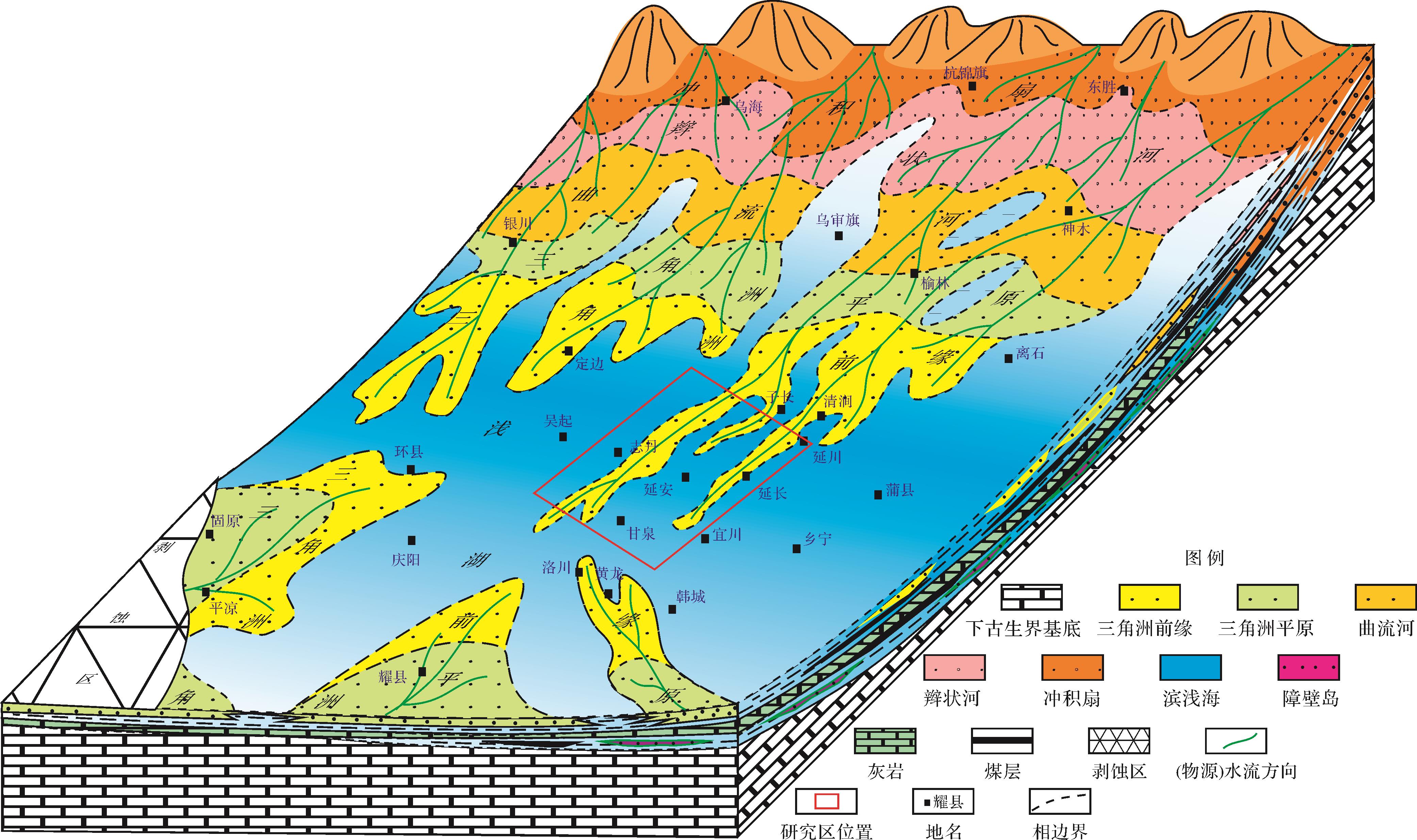
  • 经过晚石炭世本溪期—早二叠世太原期的填平补齐,早二叠世山西期,华北地块整体抬升,海水从鄂尔多斯盆地东西两侧开始逐渐退出,盆地充填形成于海退背景[2]。山西组沉积时期,研究区地势整体平坦且水体较浅[31,34],山西早期发生区域性海退,海水从东南方向退出,以陆表海沉积向近海湖盆的河流—三角洲沉积过渡[4]。山2段沉积早期,研究区主要为曲流河—三角洲沉积体系,虽受海洋潮汐作用的影响,但河流作用仍是其主导因素[12]。具有“岸线频繁迁移,水体影响范围广”的特点,以致北部三角洲分流河道砂体往南延伸几十至数百千米[2]图1)。山2段沉积期,气候温暖潮湿,发育多套煤层,季节性变化明显,多套砂体与泥岩、煤层(线)频繁交替叠置,沉积水体为淡水—半咸水环境,Sr/Ba值介于0.22~0.71[2,3536]

    Figure 1.  Sedimentary facies map of the 2nd member of the Shanxi Formation in the Ordos Basin, location of the study area marked with the red box

  • 延安地区南北向顺物源方向山2段平均坡降为2.349 m/km,平均古坡度大致为0.135°。山2段地形坡度缓,水动力弱,较弱的水动力条件控制山2段发育曲流河三角洲前缘沉积[4]。随着古坡度逐渐增大,山1段水动力有所增强,物源供给增多,发育曲流河三角洲—辫状河三角洲过渡沉积。

  • 受北部物源控制下的沉积区山2段为含煤系碎屑岩沉积。山2段储集砂体岩石类型以石英砂岩为主,其次为岩屑石英砂岩,少量岩屑砂岩,该地区以北岩屑含量相对较高[2,33]。山2段成分成熟度相对较高,石英平均含量介于63.2%~81.0%,岩屑平均含量介于6.5%~21.8%,杂基含量介于2.3%~6.9%,胶结物含量介于4.0%~9.6%,长石含量平均不超过1% [32]。根据研究区山2段样品粒度统计结果,中粗粒含量介于20%~30%,细粒含量介于30%~40%,粉砂含量介于25%~30%,泥含量介于5%~10%。

  • 本次实验在长江大学湖盆沉积模拟实验室完成。实验装置包括控制台、模拟固定河道和三角洲沉积区三个部分。控制台主要是对沉积物进行搅拌并通过河道将沉积物输送至沉积区,水槽模拟实验装置长16.0 m,宽6.0 m,深0.8 m,距地平面高2.2 m,湖盆前部设进水口一个,尾部设出水口一个。

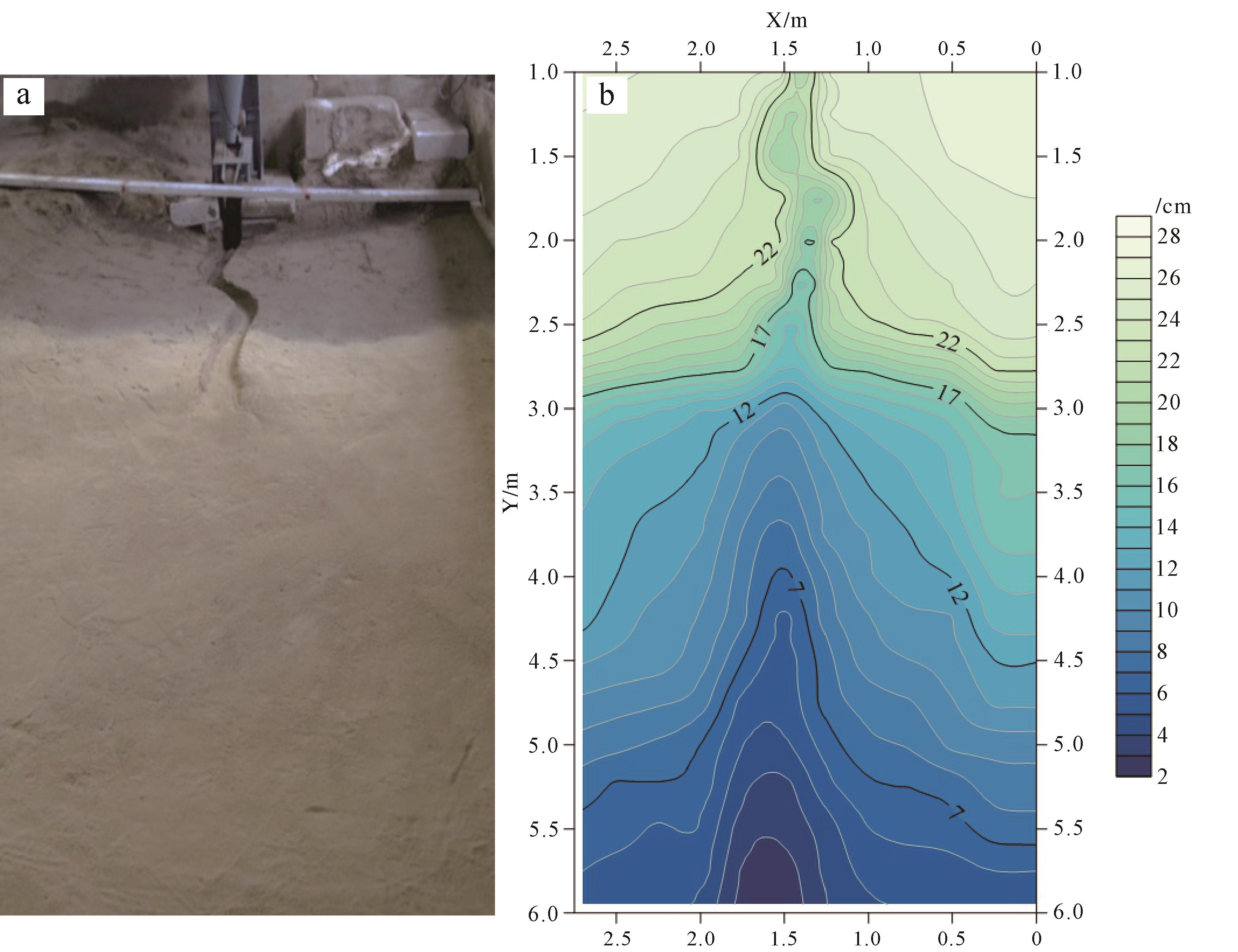
    根据地质原型,按照几何比尺进行实验底型设计。物源置于实验装置前端,X方向有效使用范围3.0 m,比尺为1∶30 000;Y方向使用范围6.0 m,比尺为1∶8 000;Z方向厚度比尺为1∶1 000。Y=0~1.0 m为固定河道区,不计入有效测量范围;Y=1.0~3.0 m为曲流河沉积区;Y=3.0~6.0 m为三角洲沉积区,河床至三角洲前缘沉积区整体坡降为2°(图2)。

    Figure 2.  Bottom and contour map of the flume simulation experiment

  • 根据研究区山2段沉积期处于水退水进频繁交替过程,设定三期的水平面变化来反映该沉积过程变化,分别为曲流河三角洲雏形形成期及水退幅度较小沉积期(Run1)、水进期(Run2)及快速水退期(Run3)。

    根据水流的搬运能力以及洪水期、中水期及枯水期含砂量的变化,设计沉积物主要由中粗砂、细砂、粉砂和泥组成,且各沉积期及不同来水条件下的沉积物粒度有所差异(表1)。

    来水特征加砂、泥组成(体积百分比%)
    Run1(水退)Run2(水进)Run3(水退)
    中粗砂细砂粉砂中粗砂细砂粉砂中粗砂细砂粉砂
    洪水期303527833372372836278
    中水期2837251030353052534356
    枯水期24402610253430112232415
    水深h/cm14.5~7.07.0~11.612.0~4.5
    岸线Y/mY=3.0~5.0Y=5.0~4.0Y=4.0~5.9
    加砂量/(g/s)0.85~1.351.35~1.650.75~1.15
    流量(L/S)0.178~0.5120.225~0.5330.125~0.486

    Table 1.  Sedimentary periods and provenance groups of the flume simulation experiment for the Shanxi Formation in the study area

  • 根据自然模型法,水流时间比例尺设计洪水:中水:枯水的时间比例为1∶2∶7。洪、中、枯三种水量,根据设计及实际情况需要在实验中进行转换,水量大小调整过程中,水量不能出现短时间内大幅度、跳跃性的变化,而是根据各个时期实际情况,以逐步增加或减少的方式,得到所要求的流量。如中水加大流量到洪水后,如果此刻需要减少流量到枯水,先将水量先减少到中水,然后再进一步控制水量,逐步过渡到枯水,即“中水—洪水—中水—枯水”模式。

  • 根据研究区山西组三角洲形成特点,自然界河流洪水、中水、枯水的流量比例[37],设计山西组曲流河三角洲入湖河流洪水∶中水∶枯水的流量比例为5∶4∶1,实验中选定洪水期流量为0.4~0.6 L/S(流速大于0.32 m/s),中水期流量为0.25~0.4 L/S(流速0.20~0.32 m/s),枯水期流量为0.1~0.25 L/S(流速小于0.20 m/s)。

  • 研究区晚古生代早期气候温润潮湿,水流量随季节发生周期性变化,从周边露头显示古水流方向整体自北向南,水动力强度变化。同时考虑实验的可操作性、水流的携砂能力,依据经验参数,按不同时期洪水、中水、枯水的加砂组成供砂,加砂量与流量比例相匹配,设计为5∶4∶1。

  • 本次实验设置三个实验期次,第一期实验模拟水退环境中曲流河三角洲砂体沉积过程;第二期实验模拟水进环境中曲流河三角洲砂体沉积过程。第三期实验模拟事件型快速水退环境中曲流河三角洲的砂体沉积过程。在第一轮和第二轮沉积结束后的砂体表面分别均匀铺上墨绿色彩砂和红色彩砂,作为沉积界面示踪剂。

  • 本实验共用时约180 h,分水平面持续下降、水平持续上升和水平面快速下降等三个沉积期,每期均按中水期—洪水期—中水期—枯水期的顺序进行,总体上以一个水退沉积模拟过程。利用控制来水、加砂量、水平面变化等实验条件,最终形成曲流河三角洲砂体沉积。

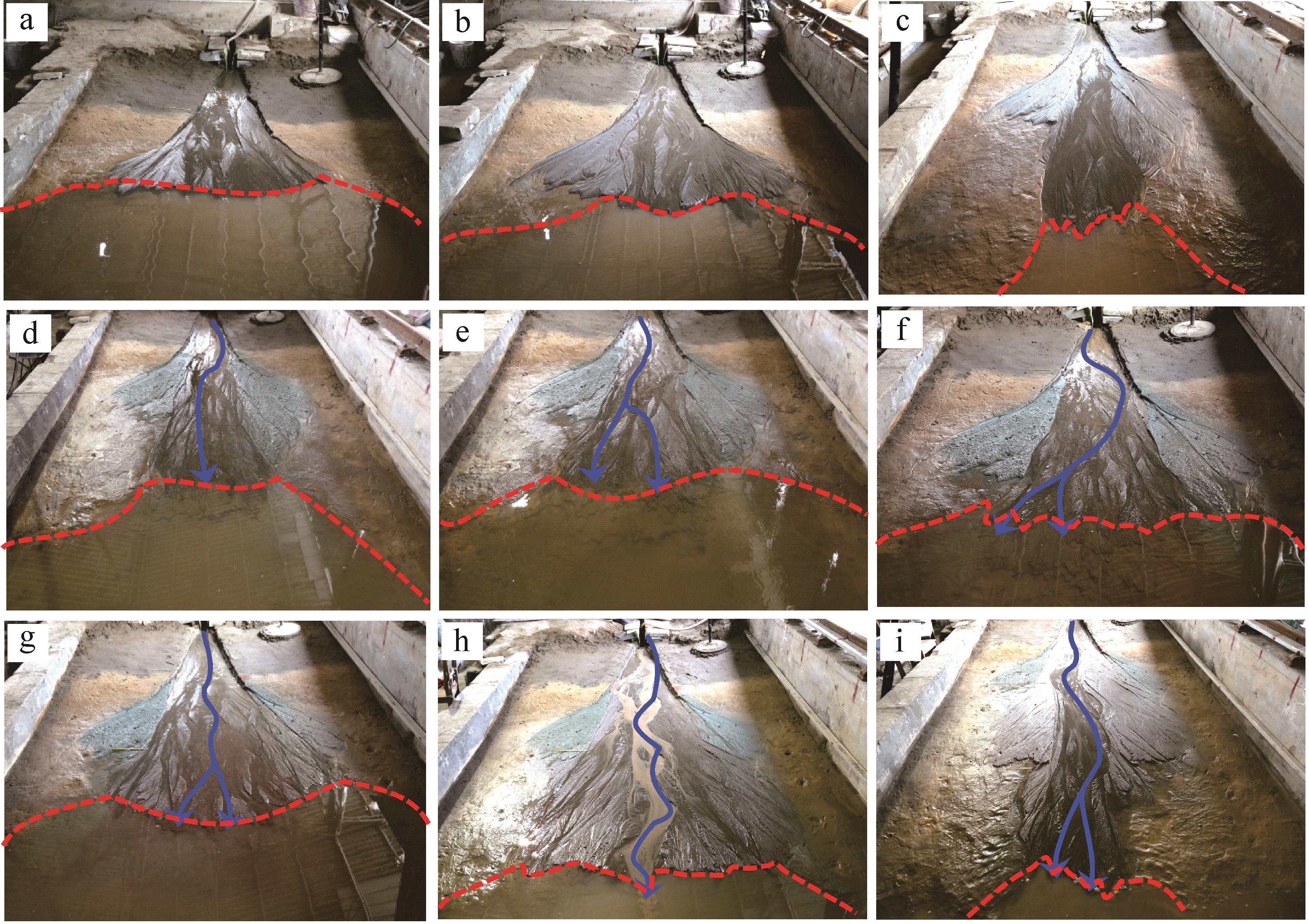
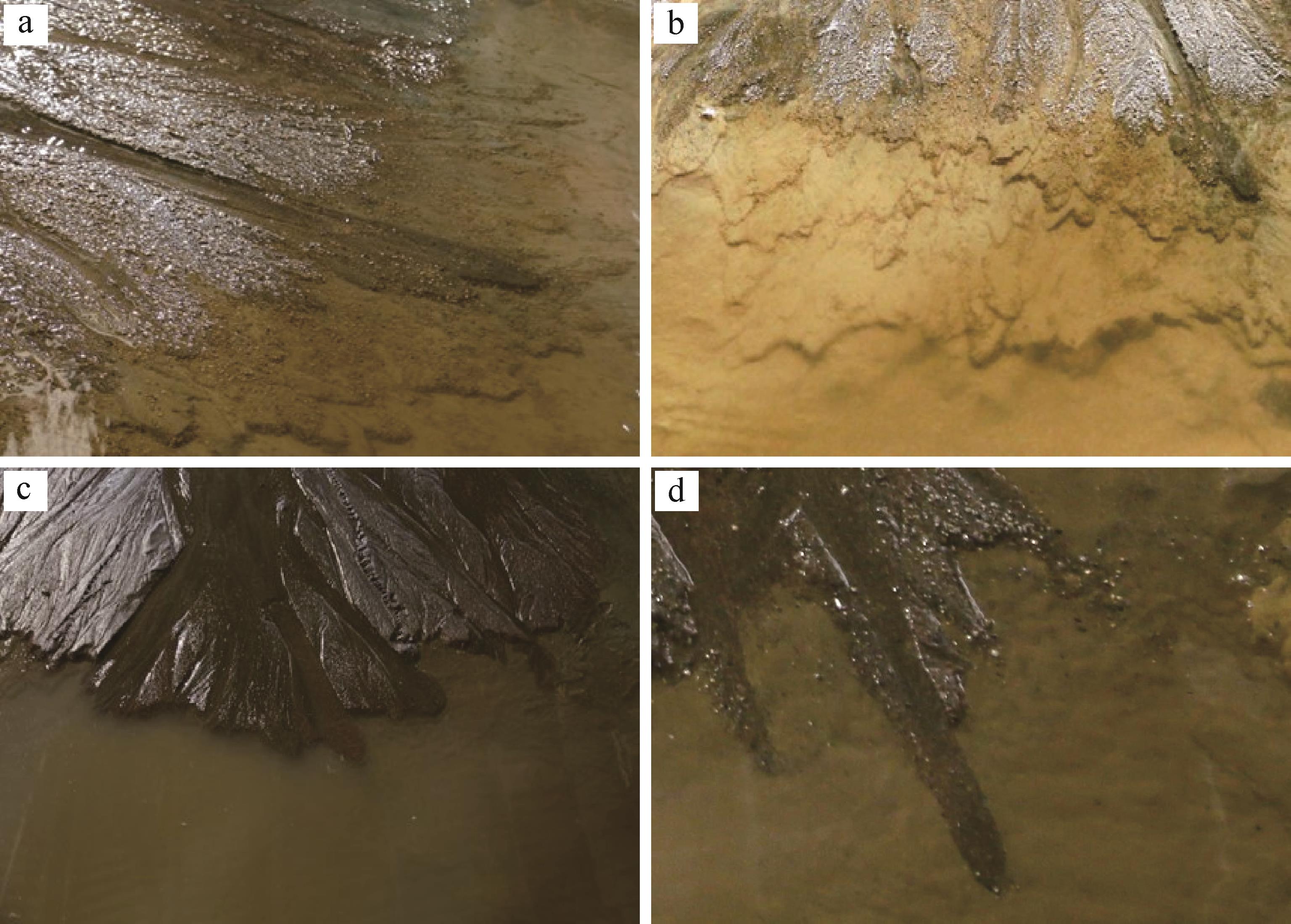
    第一期沉积实验早期水流携带泥沙沿着构筑的曲流河河道快速在河口处沉积,后逐步向湖区方向推进,于入湖处形成三角洲雏形(图3a)。该期水平面下降速度较慢,水流较分散,水道以侧向侵蚀为主,下蚀不明显,砂体纵向延伸小于横向展宽,朵体形态初步形成;之后砂体厚度增加,河道下蚀能力加强,水流逐渐汇聚,主河道开始形成,分流河道开始呈曲流特征,水下分流河道呈多支细条状延伸(图3b,c)。第二期沉积过程中,水平面持续上升,主河道不稳定,水流分散,形成多支分流河道,砂体横向展宽,湖区退积朵体垂向叠覆于早前沉积体之上,砂体整体沿着近岸线分布,发育指状砂坝(图3d~f)。第三期沉积过程中,水平面快速下降,三角洲进积,前缘砂体纵向延伸为主。主河道较为稳定,并明显切割前期砂体,上部的分支曲流河道下蚀、侧向摆动能力急剧加强,河道逐渐稳固,砂体纵向延伸能力增强;水下分流河道前端呈枝状分散延伸,致使朵体的整体形态呈枝状(图3g~i)。

    Figure 3.  Simulation experimental process of shallow water delta deposition with the gentle slope type

    在不同水动力强度条件下,沉积过程具有不同的特征。中水期,河道侵蚀作用明显,河道摆动频繁(图3b,e,h);洪水期,河道特征不明显,水流向湖方向漫流,强片流,以漫溢沉积为主(图3a,f,g);枯水期时,物源供给不足,水流沿袭原河道流动(图3c,d,g)。

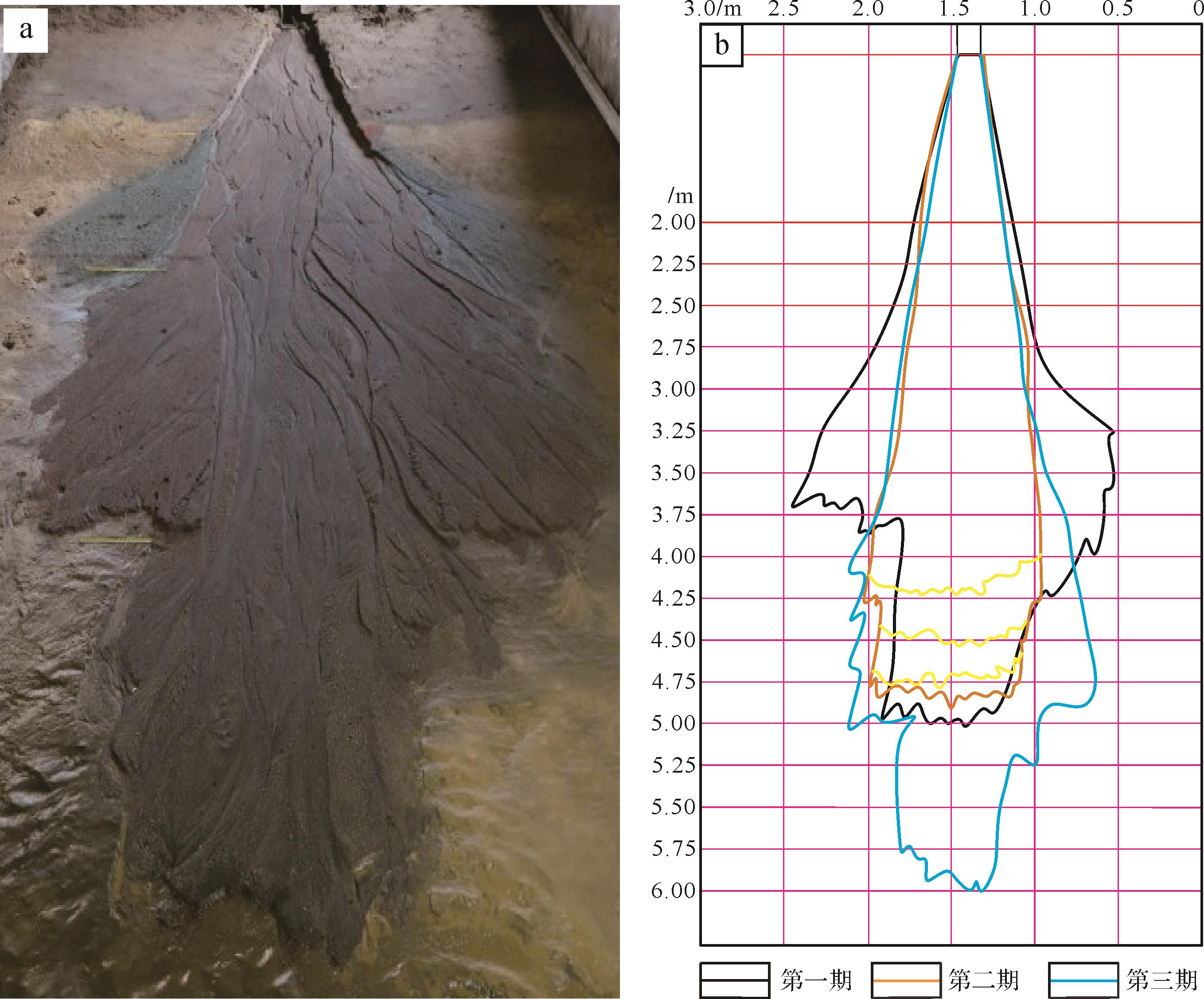
  • 各个实验沉积期结束后实测了砂体最终边界分布(图4)。砂体边界展布与供水、水平面变化密切相关。

    Figure 4.  Outer boundary for the three sedimentary periods

    从三期沉积期外缘边界分布图来看(图4),呈水退—水进—水退的连续沉积过程。Run3沉积期砂体的总体延伸距离较Run1、Run2期大幅度增加,且砂体宽度相对较窄,Run1期砂体横向展宽大于Run2和Run3沉积期,表明水平面快速下降条件下,砂体的延伸距离远远大于水平面缓慢下降时的延伸距离,而三角洲前缘横向展宽却刚好相反。因湖区水的阻力作用和平缓背景下较弱的水动力条件,Run3期沉积三角洲前缘砂体延伸最大范围整体上受岸线控制,水下分流河道延伸距离较短。河流入水时出现许多水下分流河道交织向前延伸,而水平面上升过程中会出现多条退积界线,这些界线是水平面上升河流入水时形成河口坝所致(图5)。

    Figure 5.  Characteristics of the second and third sedimentation stages

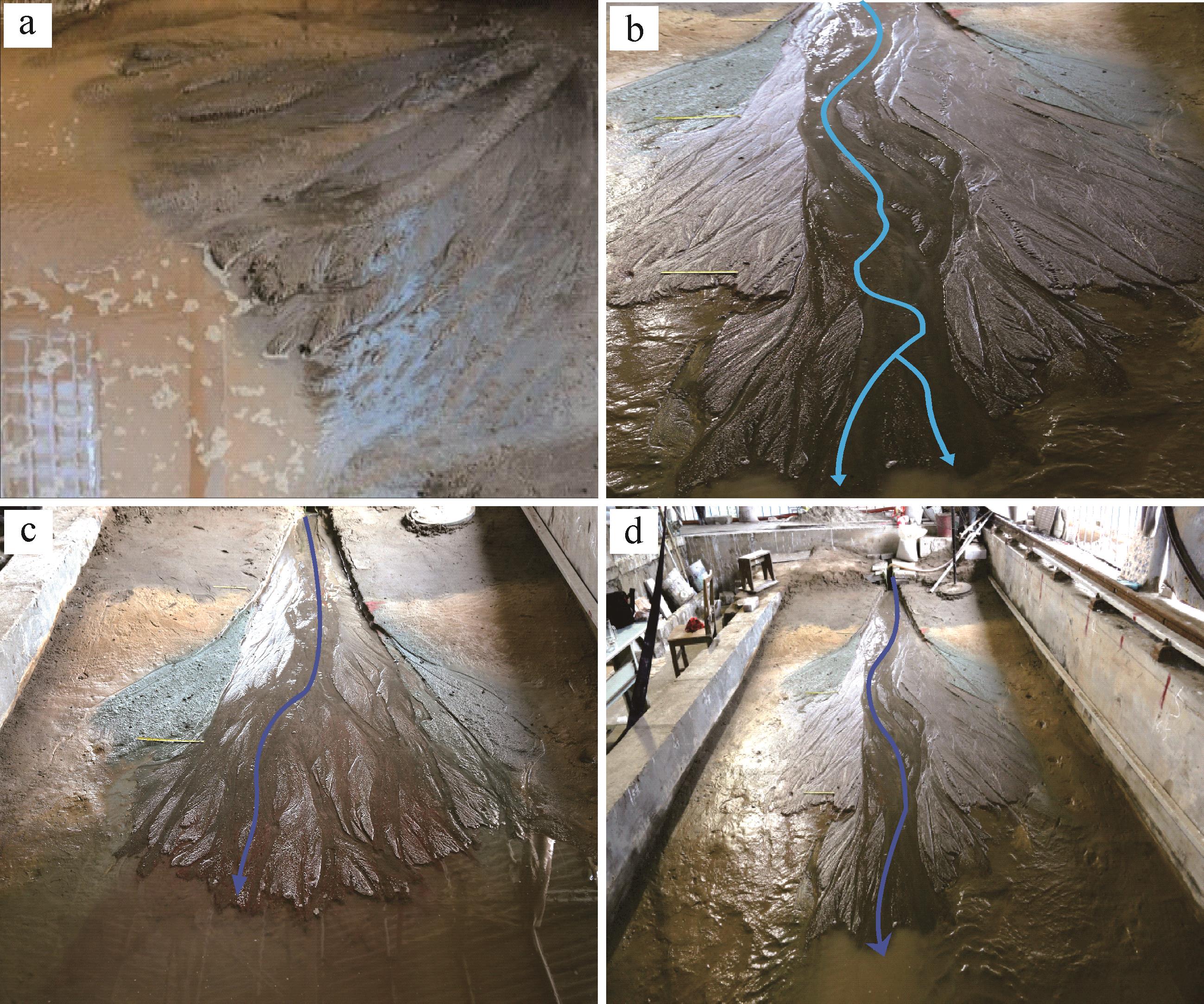
  • 不同坡度对比表明,地形坡较大,分流河道横向迁移快,具有“敞流型”特征,河道弯曲度低,易形成辫状河三角洲,有利于“满盆砂”的形成(图6a);而地形坡较小时,分流河道横向迁移慢,河道呈窄浅型,河道弯曲度高,易形成曲流河三角洲(图6b)。洪水期,水流较为分散,水流强度大,携砂能力强,河流携带的沉积物大部分会堆积在入湖处形成河口坝,形成规模较大的砂体,河道弯曲度低(图6c)。枯水期,水流流量较小时,水流较集中,水流携砂能力小,河流以弯曲状延伸入湖,河流弯曲度较高(图6d)。因此,坡度缓、流量小是河道呈曲流形态的主要因素。

    Figure 6.  Comparison of sand distribution characteristics under different slopes and flow intensities

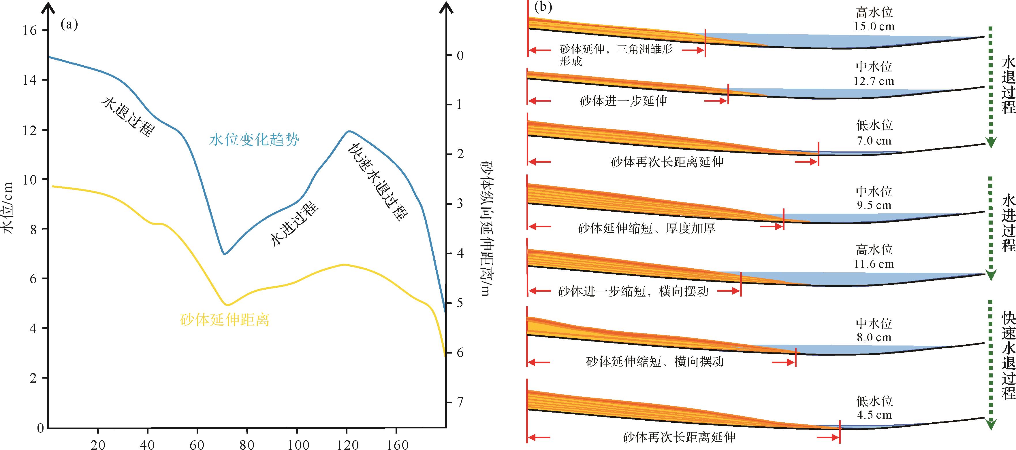
  • 第一沉积期可以明显地看到在水平面快速下降之后,砂体向主河道区域逐渐靠拢,然后收缩延伸。这是由于水平面的下降不连续导致的,水降速度为0.11 cm/h,每一次水降,河道均会经历收缩,在分散的过程中最终导致砂体整体收缩延伸。河道整体在上游向右侧迁移,下游摆至左侧,前缘水下有三股水下分流河道向前延伸(图3b,c)。

    第三沉积期水平面下降的速度为0.15 cm/h,湖平面下降的速度和幅度远远大于第一沉积期(表2图3h,i),湖盆萎缩程度较大,河流沉积作用面积更大。随着湖盆的萎缩,砂体延伸距离越来越远,大面积裸露,长条砂体的形成以河道沉积为主。分流河道窄深比随着砂体的延伸距离而逐渐升高,上游河道长条砂坝长宽比增大(图3i)。

    期次水深/cm岸线迁移幅度/cm岸线迁移速率/(cm/h)纵向延伸最大边界/m横向展布最大宽度/m纵向延伸最大距离/m砂体整体纵横比
    Run114.5~7.0Y=3.00~4.850.107Y=5.01.782.01.12
    Run27.0~11.6Y=5.00~4.000.077Y=5.0~4.21.431.20.84
    Run312~4.5Y=4.00~5.850.150Y=6.01.503.02.00

    Table 2.  Simulation of water depth, shoreline range, and maximum distance of the sand body extension in each sedimentary period of the Shanxi

    对比来看,当水平面快速下降时,河流下蚀基准面会下降,可容纳空间增大,下切侵蚀作用增强,河道向外摆动较为局限,形成较稳定的主河道,主河道携沉积物持续向前搬运,致使河道砂体整体形态在逐渐收窄的同时向前推进、纵向延伸越远。当水平面保持不变或水平面上升时,河流作用减弱,河道难以向前推进,河道摆动范围越来越广,砂体会在横向上逐渐展宽。

  • 砂体空间分布特征包括平面及垂向分布特征,且砂体的平面展布与砂体垂向演化密切相关,均受控于湖平面升降及物源供给程度等因素,从而使不同类型砂体在空间的分布规律具有一定的差异性。

    在湖平面下降速度较快、主河道较稳定、物源充足的情况下,主河道发育的两条分支河道会追逐湖岸线的变化快速向湖区延伸,说明砂体延伸程度与岸线迁移距离有关。三角洲砂体沉积过程中水退幅度、水平面下降速度与三角洲砂体纵向延伸成正比(表2)。

    在水位下降的过程中,与传统理论上的进积型不同的是,早期沉积主要发生在前期沉积体的两侧,平面上浅水三角洲的展布范围逐渐扩大,但垂向上厚度变化较小;晚期再延伸至早期砂体前缘后,河道切割早期沉积砂体沿着前三角洲地势较低的区域近顺直向湖区延伸。三角洲前缘呈枝状展布,分流河道以曲流型为主,并向湖区不断延伸且部分河道延伸较远。三角洲砂体的延伸距离与水退的幅度和速率成正比。

    砂体纵向延伸与岸线变化趋势大致一致,延伸的距离与水平面下降幅度正相关,延伸的宽度则取决于水平面的下降速度和物源供给流量的大小。水平面下降的速度决定砂体纵向延伸的速度,水平面下降的幅度决定砂体纵向延伸的距离(图7)。

    Figure 7.  Relationship between lake water level variation and sand body extension distance during water recession and inflow

  • 水平面下降导致沉积基准面下降,后期水道切割侵蚀原有的高部位砂体,并携带沉积物向湖区搬运沉积。多期的水平面下降旋回影响下,砂体纵向发育优势明显,垂向上期次分明。

    水平面上升导致基准面上升,砂体整体呈退积样式,退积规模受旋回期次和幅度影响。垂向上砂体厚度明显增长,纵向延伸不明显。

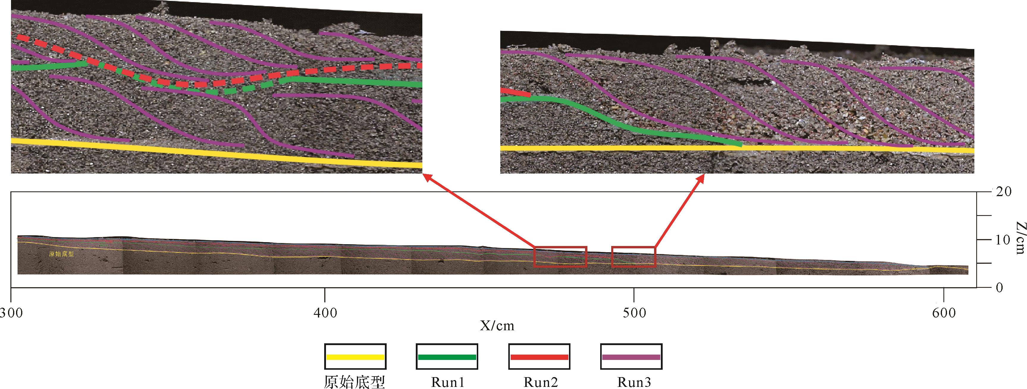
    水平面频繁升降条件控制下,砂体多期次垂向叠置,但因受水平面下降时砂体侵蚀切割影响,期次间原始沉积界线不明显。砂体纵向伸展规模受水平面变化幅度影响,幅度越大砂体纵向延伸越远。伴随多期次旋回,砂体发育形态稳定保持在随岸线沉积并向湖区延伸的长条状砂体(图8)。

    Figure 8.  Vertical section of the meandering river delta sediment (X=1.5 m)

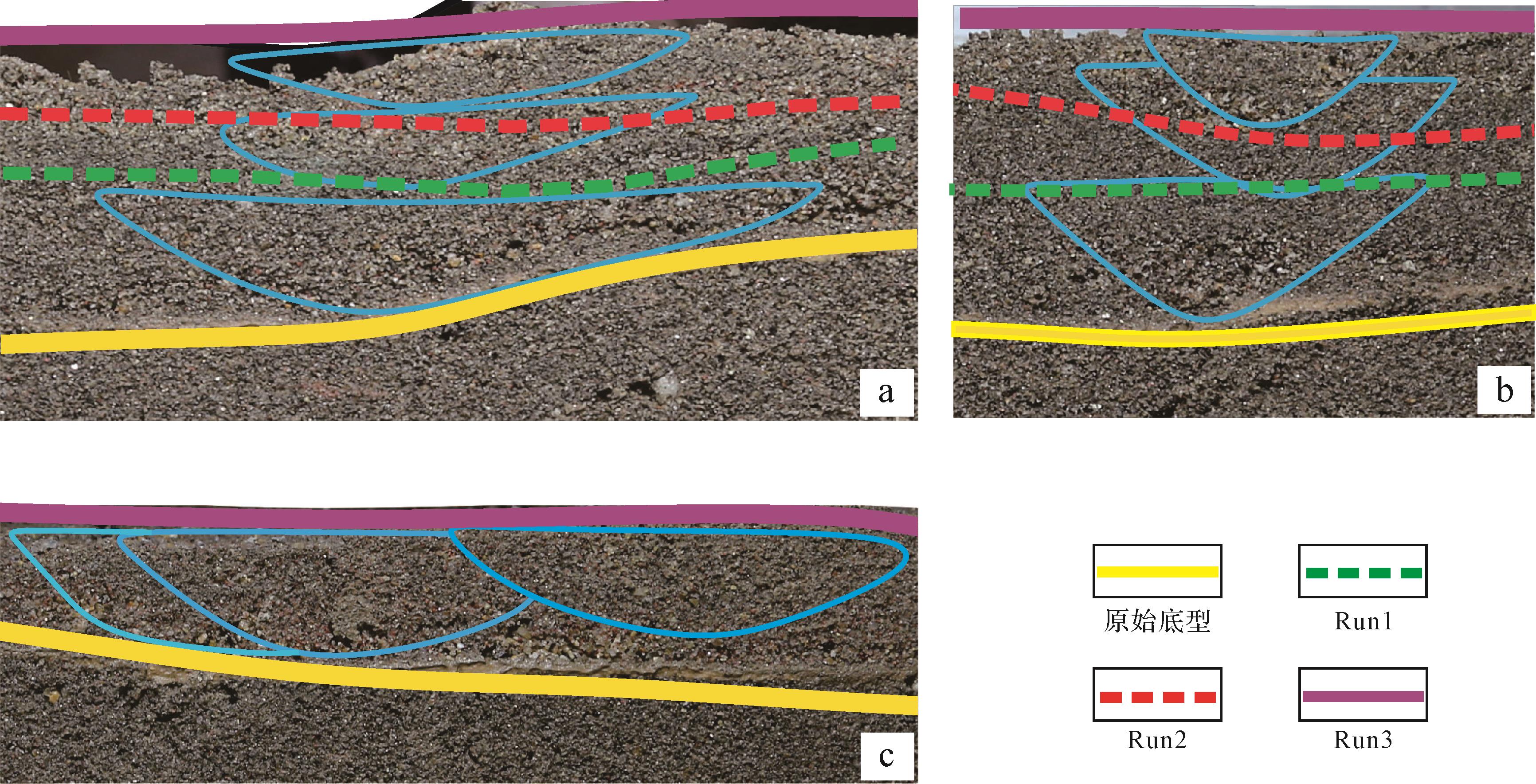
  • 在三维剖面中识别出三种砂体垂向叠置样式:垂向叠置、垂向切割、侧向迁移(图9)。

    Figure 9.  Superimposed relationship diagram of channel sand bodies

    1) 垂向叠置

    两个水下分流河道单砂体垂向上被稳定的细粒沉积所分隔,水下分流河道砂体不发生接触。两期河道表现为宽而厚的顶平底凹状,砂体粒度相对较粗,垂向上发育正粒序,上部与下部水下分流河道砂体共同表现出完整的河流相二元结构。多期分流河道砂体组合类型是指多期分流河道由下至上依次垂向叠置的组合形式,剖面结构上表现为多个正粒序的垂向排列(图9a)。

    2) 垂向切割

    垂向切割主要是指分流河道在垂向上的相互切割。两期河道砂体垂向上几乎重叠,后期发育的水下分流河道对早期发育的水下分流河道有明显的切割、侵蚀、冲刷破坏作用。两期河道表现为透镜状,粒度粗,垂向上逐渐变细,横向上粒度变化大(图9b)。

    3) 侧向迁移

    水下分流河道为单向水流,有周期性水位变化,每条分流河道的砂体沉积都是由周期水位变化的单向水流形成的。河道动能的变化就会导致河道迁移、摆动,在横剖面中可以识别出同期河道多次迁移(图9c)。

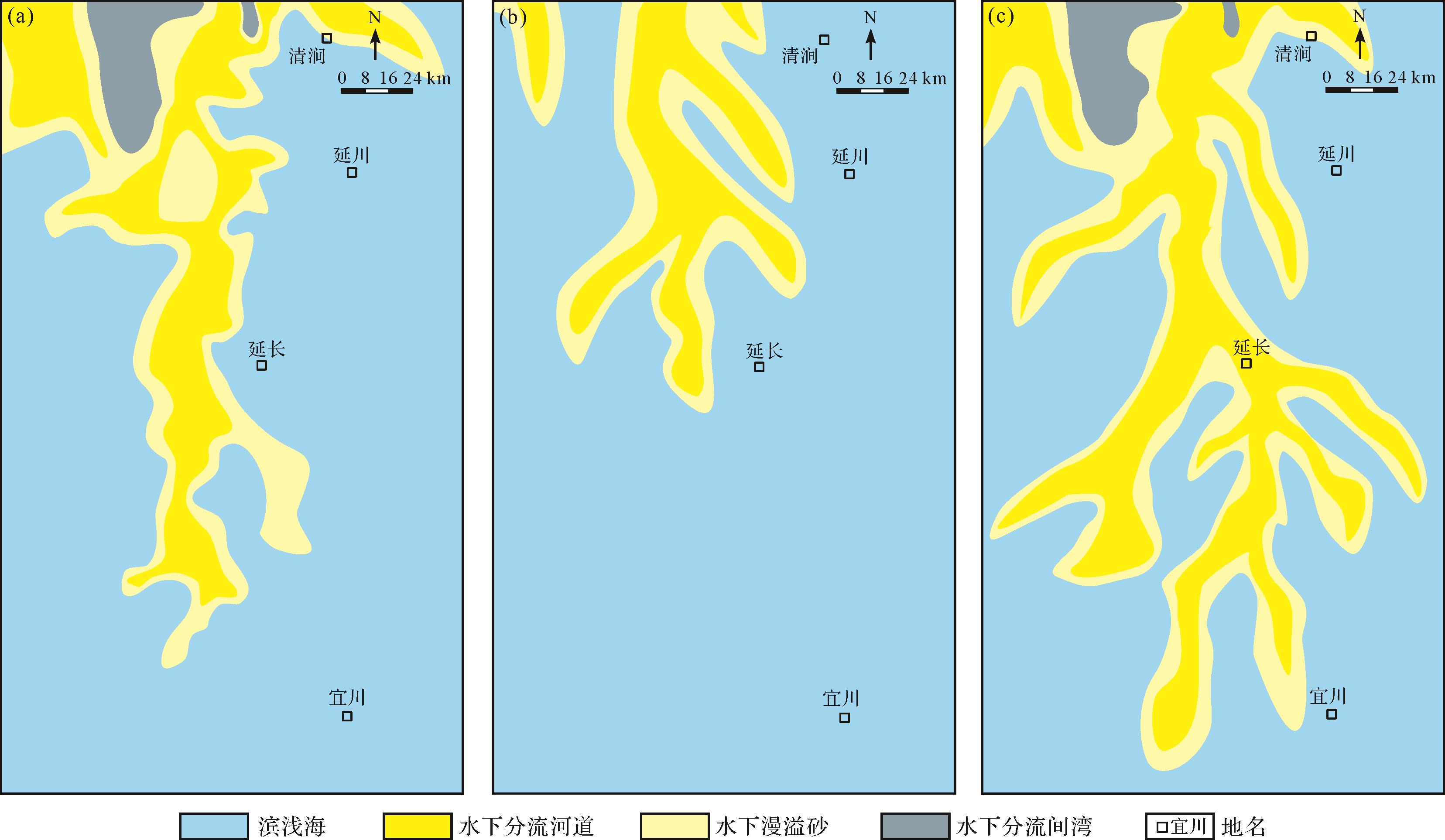
  • 勘探实践和研究发现,山西组山2段沉积期分三个阶段。山23段沉积期为海平面下降过程,岸线不断向南推进,沉积砂体自北向南延伸较远(图10a、图11),这与模拟实验中Run1期沉积过程相一致;随着水平面的持续下降,流量及供砂量减少,河流不断向前推进,河道呈浅窄曲流型,砂体顺河道向湖方向搬运(图3c)。山22段沉积期为海平面上升过程,岸线向北推进,三角洲退积,沉积砂体向南搬运距离较近(图10b、图11),模拟实验Run2期与之相似;水平面持续上升,供砂量增加,水流分散,形成多支分流河道,砂体横向展宽(图3f)。山21段沉积期海平面再次下降,岸线持续向南推进,三角洲前积,沉积砂体自北向南推向更远的距离(图10c、图11),与模拟实验Run3期具有一致性;水平面快速下降,主河道较为稳定,上部分支曲流河道下蚀,砂体纵向延伸能力增强,水下分流河道呈枝状分散延伸(图3i)。

    Figure 10.  Sedimentary facies distribution of the 2nd member of the Shanxi Formation in the Yan'an area, southeastern Ordos Basin

    Figure 11.  Superimposed vertical pattern of sand in the Shanxi Formation of the Yan'an gas field, southeastern Ordos Basin

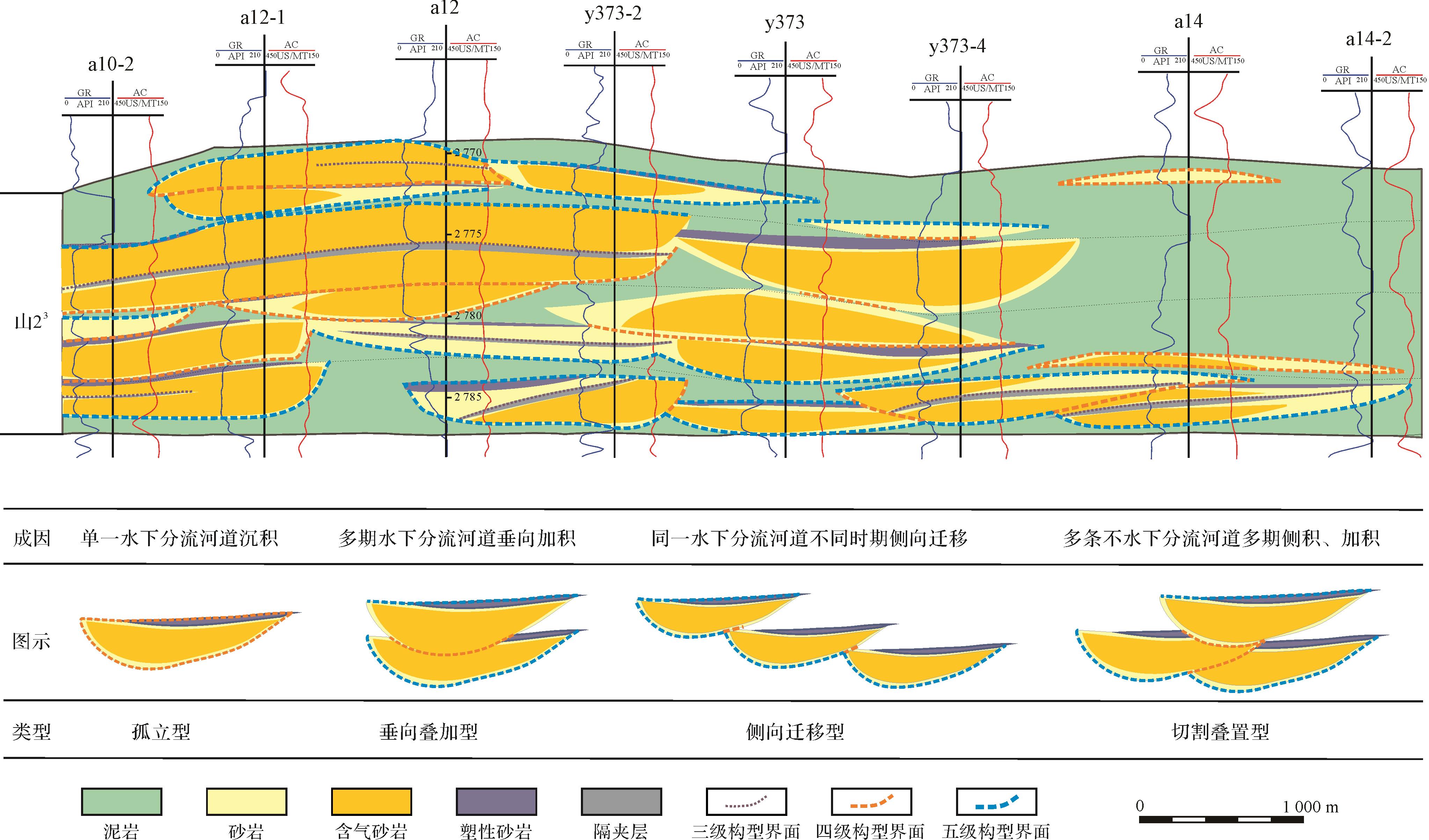
    对鄂尔多斯盆地东南部延安地区某井区山2段纵向解剖表明,山2段浅水曲流河三角洲沉积主要发育多期水下分流河道砂体,从构型叠置类型看,山2段沉积期,在多期频繁水进水退背景下主要发育垂向叠加型、切割叠置型、侧向迁移型三种构型叠置样式的复合砂体(图12)。从水槽模拟实验结果解剖来看,多个水下分流河道单砂体垂向上被稳定的细粒沉积所分割,分流河道砂体间不发生直接接触,纵向上呈现“垂向叠置”的特征(图9a);垂向切割表现在两期分流河道砂体纵向重叠,且后期河道对早期发育的河道有明显的切割、侵蚀现象(图9b);当水下分流河道为单向水流,且周期性水位变化时,就会导致河道迁移、摆动,形成侧向迁移的叠置现象(图9c)。水槽模拟实验结果与山西期山2段实际的砂体纵向叠置关系具有较好的相似性,较好地解释了山2段砂体的形成演化过程。

    Figure 12.  Superimposed sand body pattern profile of the Shan 23 member in the Yan'an gas field, southeastern Ordos Basin

  • (1) 平缓坡度与低水流强度是山2段分流河道呈低弯度曲流态的重要因素。水平面的变幅速率是控制山2段砂体纵向延伸的关键因素,砂体的大小及长宽比受岸线及流量变化控制,砂体整体的延伸距离及长宽比分别与水退的幅度和速率成正比。

    (2) 山西组沉积期,在水平面大幅度下降、岸线向湖区长距离迁移背景下,曲流河三角洲前缘砂体延伸较远距离形成长条状砂体。多期频繁水进水退导致山西组山2段砂体呈现“垂向叠置”、“垂向切割”和“侧向迁移”的叠置特征,构成山西组主要的含气储集砂体。

Reference (37)

Catalog

    /

    DownLoad:  Full-Size Img  PowerPoint
    Return
    Return